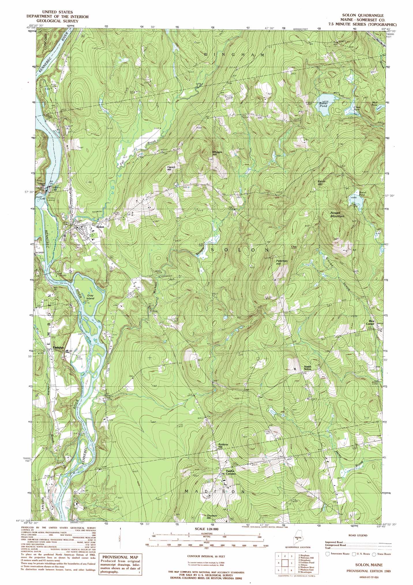
Solon Topo Map Maine
To zoom in, hover over the map of Solon
USGS Topo Quad 44069h7 - 1:24,000 scale
| Topo Map Name: | Solon |
| USGS Topo Quad ID: | 44069h7 |
| Print Size: | ca. 21 1/4" wide x 27" high |
| Southeast Coordinates: | 44.875° N latitude / 69.75° W longitude |
| Map Center Coordinates: | 44.9375° N latitude / 69.8125° W longitude |
| U.S. State: | ME |
| Filename: | o44069h7.jpg |
| Download Map JPG Image: | Solon topo map 1:24,000 scale |
| Map Type: | Topographic |
| Topo Series: | 7.5´ |
| Map Scale: | 1:24,000 |
| Source of Map Images: | United States Geological Survey (USGS) |
| Alternate Map Versions: |
Anson NE ME 1975, updated 1980 Download PDF Buy paper map Solon ME 1989, updated 1989 Download PDF Buy paper map Solon ME 2011 Download PDF Buy paper map Solon ME 2014 Download PDF Buy paper map |
1:24,000 Topo Quads surrounding Solon
East Carry Pond |
Caratunk |
Dimmick Mountain |
Foster Ridge |
Whetstone Pond |
Witham Mountain |
Bingham |
Mahoney Hill |
Kingsbury |
Wellington |
New Portland |
Embden Pond |
Solon |
Arbens |
Harmony |
New Vineyard |
Madison West |
Madison East |
Skowhegan |
Canaan |
New Sharon |
Mercer |
Norridgewock |
Hinckley |
Clinton |
> Back to 44069e1 at 1:100,000 scale
> Back to 44068a1 at 1:250,000 scale
> Back to U.S. Topo Maps home
Solon topo map: Gazetteer
Solon: Dams
Hancock Pond Dam elevation 121m 396′Williams Dam elevation 94m 308′
Solon: Falls
Caratunk Falls elevation 84m 275′Solon: Islands
Gray Island elevation 82m 269′Solon: Lakes
Baker Pond elevation 191m 626′Chase Pond elevation 190m 623′
Mud Pond elevation 186m 610′
Rowell Pond elevation 210m 688′
Solon: Populated Places
Arnolds Landing elevation 93m 305′Embden elevation 114m 374′
Rice Corner elevation 146m 479′
Solon elevation 123m 403′
South Solon elevation 194m 636′
Solon: Reservoirs
Hancock Pond elevation 121m 396′Kennebec River Reservoir elevation 87m 285′
Solon: Streams
Alder Brook elevation 84m 275′Fall Brook elevation 86m 282′
Jackin Brook elevation 78m 255′
Michael Stream elevation 82m 269′
Mill Stream elevation 86m 282′
Solon: Summits
Eaton Hill elevation 278m 912′French Hill elevation 218m 715′
Parkman Hill elevation 294m 964′
Robbins Hill elevation 194m 636′
Rowell Mountain elevation 295m 967′
Whipple Hill elevation 258m 846′
Solon digital topo map on disk
Buy this Solon topo map showing relief, roads, GPS coordinates and other geographical features, as a high-resolution digital map file on DVD:
Maine, New Hampshire, Rhode Island & Eastern Massachusetts
Buy digital topo maps: Maine, New Hampshire, Rhode Island & Eastern Massachusetts