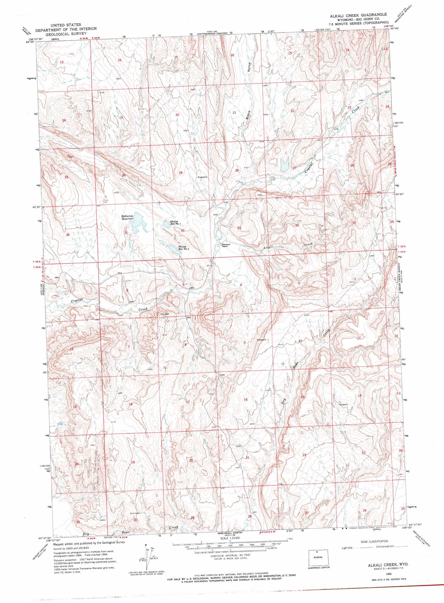
Alkali Creek Topo Map Wyoming
To zoom in, hover over the map of Alkali Creek
USGS Topo Quad 44108f1 - 1:24,000 scale
| Topo Map Name: | Alkali Creek |
| USGS Topo Quad ID: | 44108f1 |
| Print Size: | ca. 21 1/4" wide x 27" high |
| Southeast Coordinates: | 44.625° N latitude / 108° W longitude |
| Map Center Coordinates: | 44.6875° N latitude / 108.0625° W longitude |
| U.S. State: | WY |
| Filename: | o44108f1.jpg |
| Download Map JPG Image: | Alkali Creek topo map 1:24,000 scale |
| Map Type: | Topographic |
| Topo Series: | 7.5´ |
| Map Scale: | 1:24,000 |
| Source of Map Images: | United States Geological Survey (USGS) |
| Alternate Map Versions: |
Alkali Creek WY 1966, updated 1970 Download PDF Buy paper map Alkali Creek WY 2012 Download PDF Buy paper map Alkali Creek WY 2015 Download PDF Buy paper map |
1:24,000 Topo Quads surrounding Alkali Creek
Sykes Spring |
Natural Trap Cave |
Simmons Canyon |
Mexican Hill |
Boyd Ridge |
Lovell Lakes |
Kane |
Cottonwood Canyon |
Medicine Wheel |
Bald Mountain |
North Emblem Reservoir |
Spence |
Alkali Creek |
Bear Creek Ranch |
Leavitt Reservoir |
Emblem Se |
Sheep Canyon |
Greybull North |
Devils Kitchen |
Shell |
Otto |
Gould Butte |
Greybull South |
Wild Horse Flats |
Manderson Ne |
> Back to 44108e1 at 1:100,000 scale
> Back to 44108a1 at 1:250,000 scale
> Back to U.S. Topo Maps home
Alkali Creek topo map: Gazetteer
Alkali Creek: Dams
Bethurem Dam elevation 1234m 4048′Brown Number 1 Dam elevation 1228m 4028′
Brown Number 2 Dam elevation 1226m 4022′
Eberhard Number 1 Dam elevation 1305m 4281′
Alkali Creek: Mines
Bear Creek Number One Mine elevation 1325m 4347′Alkali Creek: Reservoirs
Bethurem Reservoir elevation 1234m 4048′Brown Number 1 Reservoir elevation 1228m 4028′
Brown Number 2 Reservoir elevation 1226m 4022′
Eberhard Number 1 Reservoir elevation 1305m 4281′
Alkali Creek: Streams
Dry Bear Creek elevation 1413m 4635′Alkali Creek digital topo map on disk
Buy this Alkali Creek topo map showing relief, roads, GPS coordinates and other geographical features, as a high-resolution digital map file on DVD: