Boulder Chain Lakes Topo Map Idaho
To zoom in, hover over the map of Boulder Chain Lakes
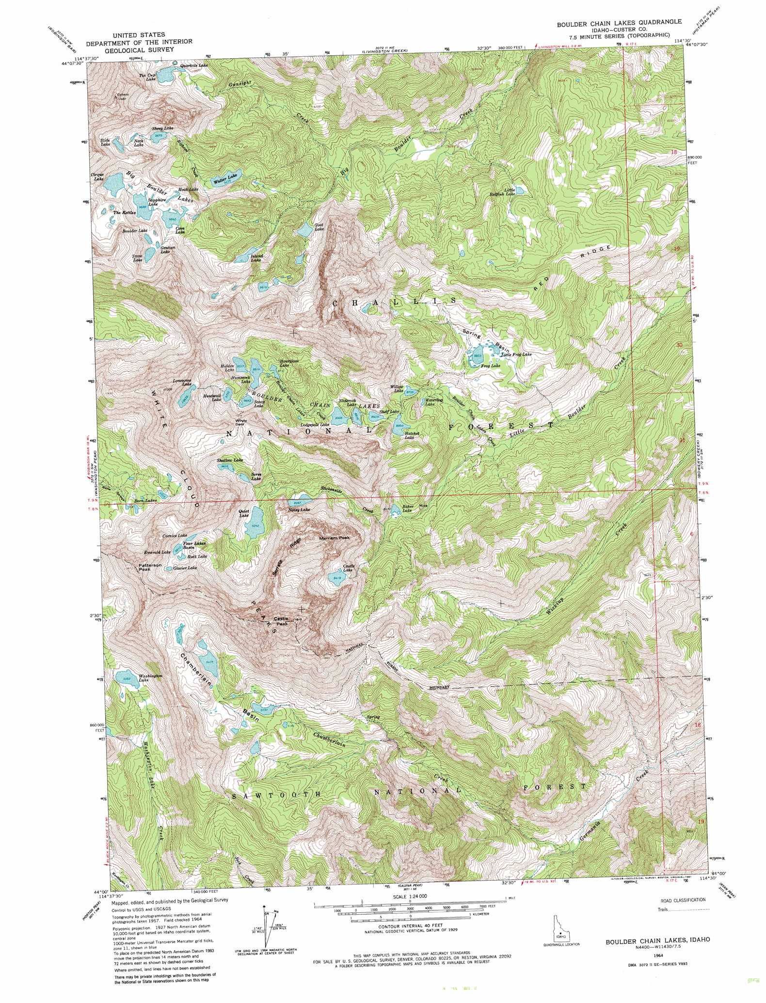
USGS Topo Quad 44114a5 - 1:24,000 scale
| Topo Map Name: | Boulder Chain Lakes |
| USGS Topo Quad ID: | 44114a5 |
| Print Size: | ca. 21 1/4" wide x 27" high |
| Southeast Coordinates: | 44° N latitude / 114.5° W longitude |
| Map Center Coordinates: | 44.0625° N latitude / 114.5625° W longitude |
| U.S. State: | ID |
| Filename: | o44114a5.jpg |
| Download Map JPG Image: | Boulder Chain Lakes topo map 1:24,000 scale |
| Map Type: | Topographic |
| Topo Series: | 7.5´ |
| Map Scale: | 1:24,000 |
| Source of Map Images: | United States Geological Survey (USGS) |
| Alternate Map Versions: |
Boulder Chain Lakes ID 1964, updated 1965 Download PDF Buy paper map Boulder Chain Lakes ID 1964, updated 1971 Download PDF Buy paper map Boulder Chain Lakes ID 1964, updated 1981 Download PDF Buy paper map Boulder Chain Lakes ID 1964, updated 1981 Download PDF Buy paper map Boulder Chain Lakes ID 2011 Download PDF Buy paper map Boulder Chain Lakes ID 2013 Download PDF Buy paper map |
| FStopo: | US Forest Service topo Boulder Chain Lakes is available: Download FStopo PDF Download FStopo TIF |
1:24,000 Topo Quads surrounding Boulder Chain Lakes
East Basin Creek |
Sunbeam |
Thompson Creek |
Clayton |
Bald Mountain |
Casino Lakes |
Robinson Bar |
Livingston Creek |
Potaman Peak |
Ziegler Basin |
Obsidian |
Washington Peak |
Boulder Chain Lakes |
Bowery Creek |
Bowery Peak |
Alturas Lake |
Horton Peak |
Galena Peak |
Ryan Peak |
Meridian Peak |
Frenchman Creek |
Galena |
Easley Hot Springs |
Amber Lakes |
Rock Roll Canyon |
> Back to 44114a1 at 1:100,000 scale
> Back to 44114a1 at 1:250,000 scale
> Back to U.S. Topo Maps home
Boulder Chain Lakes topo map: Gazetteer
Boulder Chain Lakes: Basins
Chamberlain Basin elevation 2864m 9396′Four Lakes Basin elevation 3048m 10000′
Spring Basin elevation 2709m 8887′
The Kettles elevation 3152m 10341′
Boulder Chain Lakes: Gaps
Windy Devil elevation 3056m 10026′Boulder Chain Lakes: Lakes
Baker Lake elevation 2581m 8467′Big Boulder Lakes elevation 3043m 9983′
Boorn Lakes elevation 2885m 9465′
Boulder Chain Lakes elevation 2762m 9061′
Boulder Lake elevation 3059m 10036′
Castle Lake elevation 2872m 9422′
Cirque Lake elevation 3068m 10065′
Cornice Lake elevation 3009m 9872′
Cove Lake elevation 3001m 9845′
Emerald Lake elevation 3021m 9911′
Frog Lake elevation 2701m 8861′
Frog Lakes elevation 2700m 8858′
Gentian Lake elevation 3062m 10045′
Glacier Lake elevation 3045m 9990′
Goat Lake elevation 2727m 8946′
Hatchet Lake elevation 2709m 8887′
Headwall Lake elevation 2975m 9760′
Hidden Lake elevation 2902m 9520′
Hook Lake elevation 3023m 9917′
Hourglass Lake elevation 2900m 9514′
Hummock Lake elevation 2902m 9520′
Island Lake elevation 2826m 9271′
Little Frog Lake elevation 2703m 8868′
Little Redfish Lake elevation 2676m 8779′
Lodgepole Lake elevation 2747m 9012′
Lonesome Lake elevation 3182m 10439′
Neck Lake elevation 3062m 10045′
Noisy Lake elevation 2744m 9002′
Quartzite Lake elevation 3044m 9986′
Quiet Lake elevation 2819m 9248′
Rock Lake elevation 3020m 9908′
Sapphire Lake elevation 3015m 9891′
Scoop Lake elevation 2941m 9648′
Scree Lake elevation 2908m 9540′
Shallow Lake elevation 2938m 9639′
Sheep Lake elevation 3011m 9878′
Shelf Lake elevation 2726m 8943′
Slide Lake elevation 3105m 10187′
Sliderock Lake elevation 2738m 8982′
Snow Lake elevation 3053m 10016′
Tin Cup Lake elevation 3043m 9983′
Tiny Lake elevation 2903m 9524′
Walker Lake elevation 2818m 9245′
Washington Lake elevation 2855m 9366′
Waterdog Lake elevation 2669m 8756′
Willow Lake elevation 2667m 8750′
Boulder Chain Lakes: Pillars
Castle Peak elevation 3564m 11692′Patterson Peak elevation 3295m 10810′
White Cloud Peaks elevation 3310m 10859′
Boulder Chain Lakes: Ridges
Red Ridge elevation 2768m 9081′Serrate Ridge elevation 3223m 10574′
Boulder Chain Lakes: Streams
Bighorn Creek elevation 2818m 9245′Boulder Chain Lakes Creek elevation 2474m 8116′
Chamberlain Creek elevation 2142m 7027′
Gunsight Creek elevation 2592m 8503′
Slickenside Creek elevation 2608m 8556′
Boulder Chain Lakes: Summits
Merriam Peak elevation 3325m 10908′Boulder Chain Lakes digital topo map on disk
Buy this Boulder Chain Lakes topo map showing relief, roads, GPS coordinates and other geographical features, as a high-resolution digital map file on DVD: