Robbins Gulch Topo Map Montana
To zoom in, hover over the map of Robbins Gulch
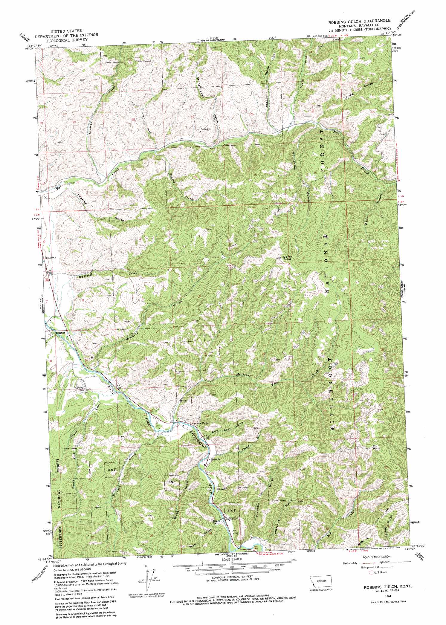
USGS Topo Quad 45114h1 - 1:24,000 scale
| Topo Map Name: | Robbins Gulch |
| USGS Topo Quad ID: | 45114h1 |
| Print Size: | ca. 21 1/4" wide x 27" high |
| Southeast Coordinates: | 45.875° N latitude / 114° W longitude |
| Map Center Coordinates: | 45.9375° N latitude / 114.0625° W longitude |
| U.S. State: | MT |
| Filename: | o45114h1.jpg |
| Download Map JPG Image: | Robbins Gulch topo map 1:24,000 scale |
| Map Type: | Topographic |
| Topo Series: | 7.5´ |
| Map Scale: | 1:24,000 |
| Source of Map Images: | United States Geological Survey (USGS) |
| Alternate Map Versions: |
Robbins Gulch MT 1964, updated 1968 Download PDF Buy paper map Robbins Gulch MT 1964, updated 1985 Download PDF Buy paper map Robbins Gulch MT 1998, updated 2002 Download PDF Buy paper map Robbins Gulch MT 2011 Download PDF Buy paper map Robbins Gulch MT 2014 Download PDF Buy paper map |
| FStopo: | US Forest Service topo Robbins Gulch is available: Download FStopo PDF Download FStopo TIF |
1:24,000 Topo Quads surrounding Robbins Gulch
Ward Mountain |
Hamilton South |
Mountain House |
Gird Point |
Skalkaho Pass |
Como Peaks |
Darby |
Deer Mountain |
Bald Top Mountain |
Kent Peak |
Trapper Peak |
Burnt Ridge |
Robbins Gulch |
French Basin |
Jennings Camp Creek |
Boulder Peak |
Piquett Creek |
Medicine Hot Springs |
Sula |
Schultz Saddle |
Painted Rocks Lake |
Piquett Mountain |
Overwhich Falls |
Lost Trail Pass |
Elk Creek |
> Back to 45114e1 at 1:100,000 scale
> Back to 45114a1 at 1:250,000 scale
> Back to U.S. Topo Maps home
Robbins Gulch topo map: Gazetteer
Robbins Gulch: Bridges
East Fork of the Bitterroot River Bridge elevation 1244m 4081′Robbins Gulch: Cliffs
Elk Point elevation 2033m 6669′Robbins Gulch: Flats
Beam Flat elevation 1287m 4222′Robbins Gulch: Parks
Medicine Tree Historical Marker elevation 1283m 4209′Robbins Gulch: Populated Places
Conner elevation 1224m 4015′Shigley Mobile Home Park elevation 1393m 4570′
Robbins Gulch: Post Offices
Conner Post Office elevation 1224m 4015′Evelyn Post Office (historical) elevation 1247m 4091′
Robbins Gulch: Streams
Beam Creek elevation 1278m 4192′Benson Creek elevation 1247m 4091′
Dickson Creek elevation 1253m 4110′
Fox Creek elevation 1342m 4402′
Laird Creek elevation 1287m 4222′
Lowman Creek elevation 1233m 4045′
Medicine Tree Creek elevation 1260m 4133′
North Fork Rye Creek elevation 1283m 4209′
South Fork Spade Creek elevation 1271m 4169′
Spade Creek elevation 1244m 4081′
Whitsell Creek elevation 1235m 4051′
Robbins Gulch: Summits
Doran Point elevation 1906m 6253′Robbins Gulch: Valleys
Bear Gulch elevation 1386m 4547′Billy Goat Gulch elevation 1271m 4169′
Blind Draw elevation 1271m 4169′
Charley Gulch elevation 1218m 3996′
Dugout Gulch elevation 1295m 4248′
Franklin Gulch elevation 1289m 4229′
Lawrence Gulch elevation 1308m 4291′
Moonshine Gulch elevation 1305m 4281′
Robbins Gulch elevation 1251m 4104′
Spring Gulch elevation 1315m 4314′
Stonehouse Gulch elevation 1282m 4206′
Whiskey Gulch elevation 1261m 4137′
Robbins Gulch: Wells
02N20W22CBCA01 Well elevation 1263m 4143′Robbins Gulch digital topo map on disk
Buy this Robbins Gulch topo map showing relief, roads, GPS coordinates and other geographical features, as a high-resolution digital map file on DVD: