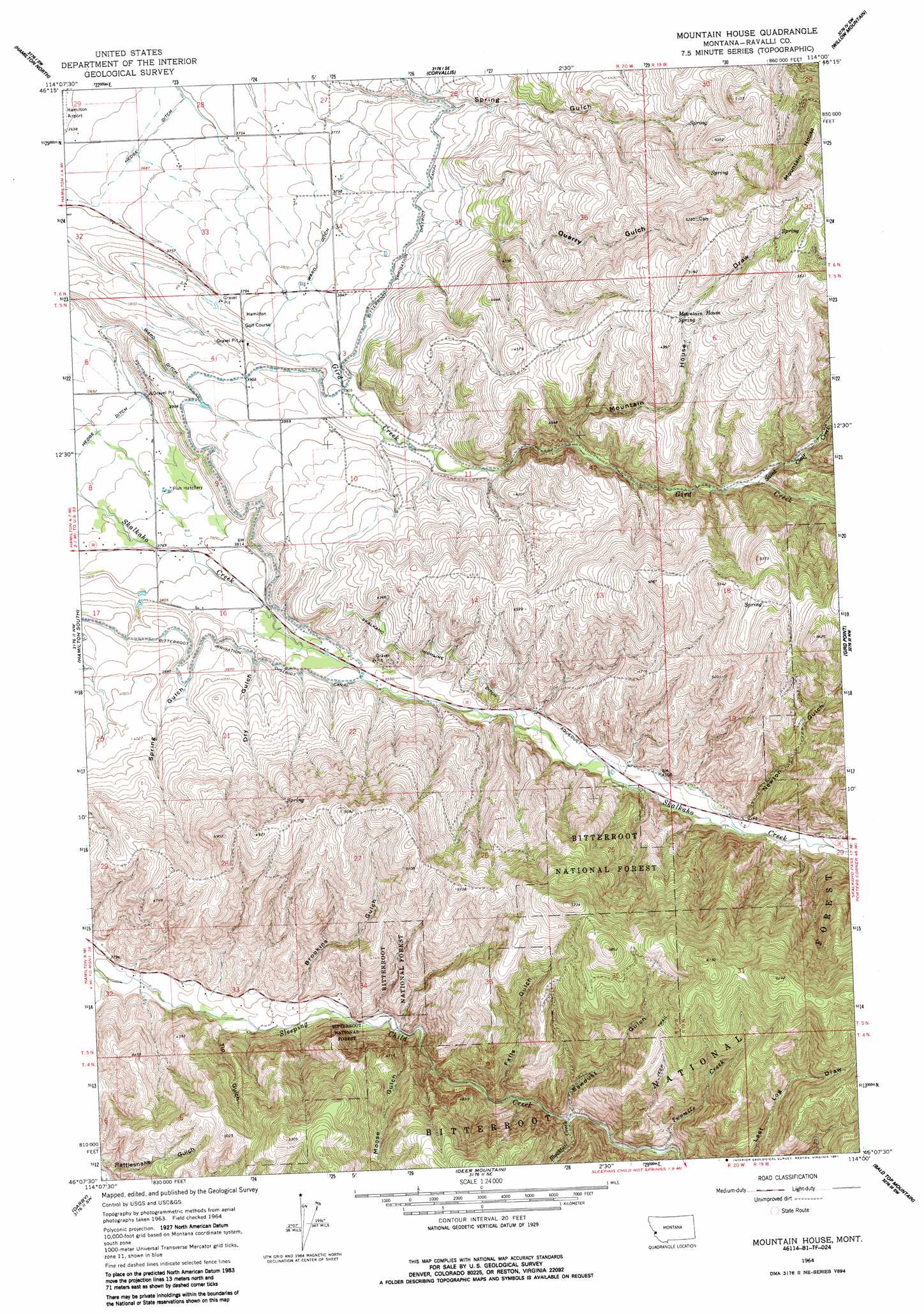
Mountain House Topo Map Montana
To zoom in, hover over the map of Mountain House
USGS Topo Quad 46114b1 - 1:24,000 scale
| Topo Map Name: | Mountain House |
| USGS Topo Quad ID: | 46114b1 |
| Print Size: | ca. 21 1/4" wide x 27" high |
| Southeast Coordinates: | 46.125° N latitude / 114° W longitude |
| Map Center Coordinates: | 46.1875° N latitude / 114.0625° W longitude |
| U.S. State: | MT |
| Filename: | o46114b1.jpg |
| Download Map JPG Image: | Mountain House topo map 1:24,000 scale |
| Map Type: | Topographic |
| Topo Series: | 7.5´ |
| Map Scale: | 1:24,000 |
| Source of Map Images: | United States Geological Survey (USGS) |
| Alternate Map Versions: |
Mountain House MT 1964, updated 1968 Download PDF Buy paper map Mountain House MT 1964, updated 1987 Download PDF Buy paper map Mountain House MT 1998, updated 2002 Download PDF Buy paper map Mountain House MT 2011 Download PDF Buy paper map Mountain House MT 2014 Download PDF Buy paper map |
| FStopo: | US Forest Service topo Mountain House is available: Download FStopo PDF Download FStopo TIF |
1:24,000 Topo Quads surrounding Mountain House
Gash Point |
Victor |
Bing |
Corley Gulch |
Sawmill Saddle |
Printz Ridge |
Hamilton North |
Corvallis |
Willow Mountain |
Burnt Fork Lake |
Ward Mountain |
Hamilton South |
Mountain House |
Gird Point |
Skalkaho Pass |
Como Peaks |
Darby |
Deer Mountain |
Bald Top Mountain |
Kent Peak |
Trapper Peak |
Burnt Ridge |
Robbins Gulch |
French Basin |
Jennings Camp Creek |
> Back to 46114a1 at 1:100,000 scale
> Back to 46114a1 at 1:250,000 scale
> Back to U.S. Topo Maps home
Mountain House topo map: Gazetteer
Mountain House: Canals
Skalkaho Highline Ditch elevation 1264m 4146′Ward Ditch elevation 1177m 3861′
Mountain House: Mines
SW NE Section 2 Mine elevation 1334m 4376′Mountain House: Springs
Mountain House Spring elevation 1500m 4921′Mountain House: Streams
Blacktail Creek elevation 1275m 4183′Saint Clair Creek elevation 1324m 4343′
Twomile Creek elevation 1302m 4271′
Mountain House: Summits
Mountain House elevation 1769m 5803′Mountain House: Valleys
Brookins Gulch elevation 1209m 3966′Dry Gulch elevation 1194m 3917′
Falls Gulch elevation 1255m 4117′
Moose Gulch elevation 1212m 3976′
Mountain House Draw elevation 1273m 4176′
Newton Gulch elevation 1278m 4192′
Quarry Gulch elevation 1194m 3917′
Sawdust Gulch elevation 1279m 4196′
Spring Gulch elevation 1195m 3920′
Tip Gulch elevation 1182m 3877′
Mountain House: Wells
05N20W04ACD_01 Well elevation 1184m 3884′05N20W10BAAC01 Well elevation 1215m 3986′
05N20W23BAC_01 Well elevation 1220m 4002′
05N20W23BBA_01 Well elevation 1213m 3979′
05N20W33BCCD01 Well elevation 1177m 3861′
Mountain House digital topo map on disk
Buy this Mountain House topo map showing relief, roads, GPS coordinates and other geographical features, as a high-resolution digital map file on DVD: