Washboard Ridge Topo Map Oregon
To zoom in, hover over the map of Washboard Ridge
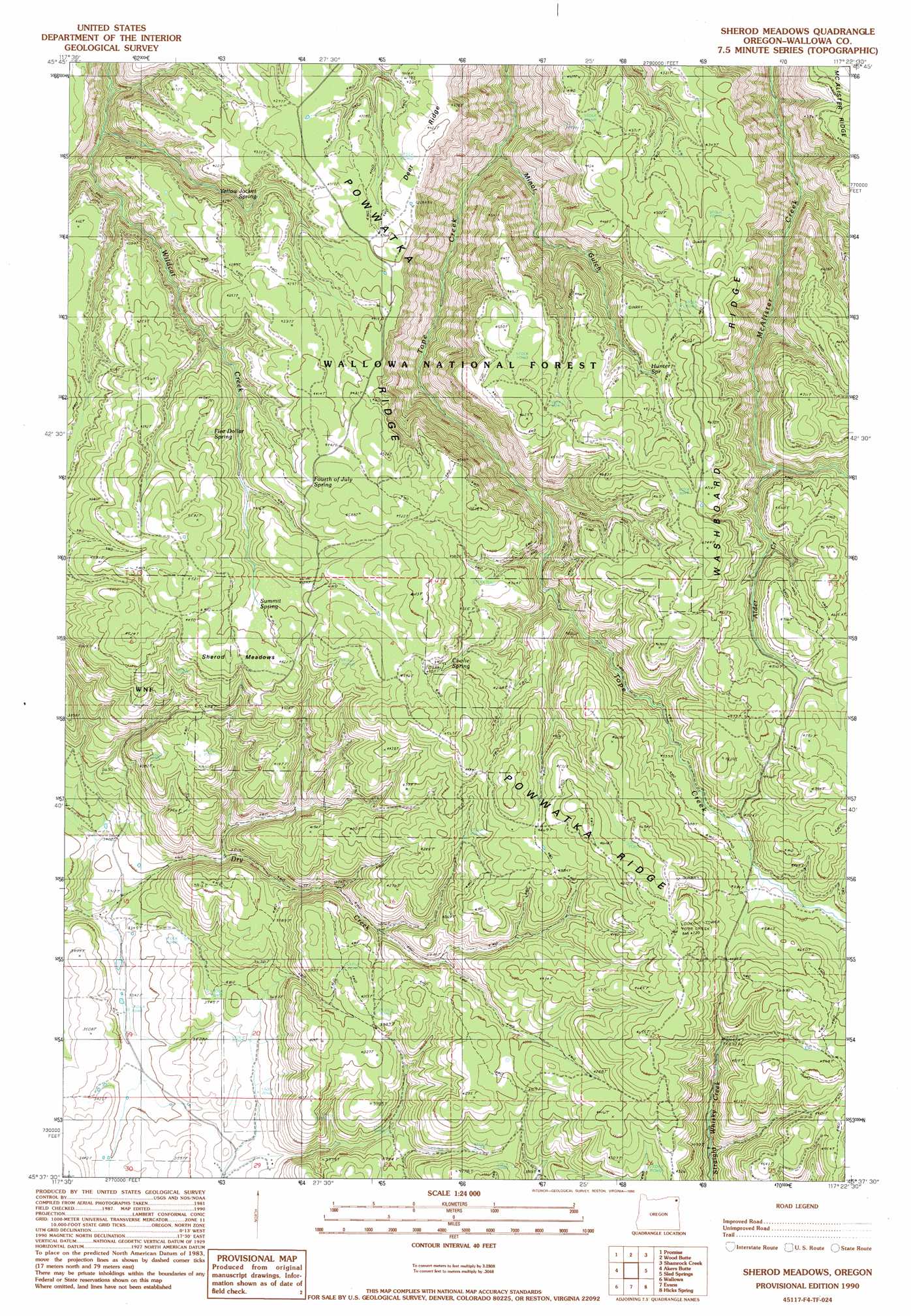
USGS Topo Quad 45117f4 - 1:24,000 scale
| Topo Map Name: | Washboard Ridge |
| USGS Topo Quad ID: | 45117f4 |
| Print Size: | ca. 21 1/4" wide x 27" high |
| Southeast Coordinates: | 45.625° N latitude / 117.375° W longitude |
| Map Center Coordinates: | 45.6875° N latitude / 117.4375° W longitude |
| U.S. State: | OR |
| Filename: | o45117f4.jpg |
| Download Map JPG Image: | Washboard Ridge topo map 1:24,000 scale |
| Map Type: | Topographic |
| Topo Series: | 7.5´ |
| Map Scale: | 1:24,000 |
| Source of Map Images: | United States Geological Survey (USGS) |
| Alternate Map Versions: |
Sherod Meadows OR 1990, updated 1990 Download PDF Buy paper map Sherod Meadows OR 2011 Download PDF Buy paper map Sherod Meadows OR 2014 Download PDF Buy paper map |
| FStopo: | US Forest Service topo Sherod Meadows is available: Download FStopo PDF Download FStopo TIF |
1:24,000 Topo Quads surrounding Washboard Ridge
Elbow Creek |
Eden |
Troy |
Flora |
Paradise |
Deep Creek |
Promise |
Wood Butte |
Shamrock Creek |
Table Mountain |
Howard Butte |
Akers Butte |
Washboard Ridge |
Sled Springs |
Starvation Ridge |
Minam |
Wallowa |
Evans |
Hicks Spring |
Elk Mountain |
Mount Moriah |
Fox Point |
Lostine |
Enterprise |
Joseph Nw |
> Back to 45117e1 at 1:100,000 scale
> Back to 45116a1 at 1:250,000 scale
> Back to U.S. Topo Maps home
Washboard Ridge topo map: Gazetteer
Washboard Ridge: Flats
Sherod Meadows elevation 1358m 4455′Washboard Ridge: Ridges
Deer Ridge elevation 1327m 4353′Hidden Ridge elevation 1418m 4652′
Powwatka Ridge elevation 1430m 4691′
Washboard Ridge elevation 1388m 4553′
Washboard Ridge: Springs
Alder Spring elevation 1396m 4580′Coolie Spring elevation 1327m 4353′
Five Dollar Spring elevation 1317m 4320′
Fourth of July Spring elevation 1363m 4471′
Hunter Spring elevation 1378m 4520′
Minor Spring elevation 1339m 4393′
Rockwall Spring elevation 1323m 4340′
Summit Spring elevation 1335m 4379′
Yellow Jacket Spring elevation 1235m 4051′
Washboard Ridge: Streams
Alder Creek elevation 1267m 4156′Hidden Branch elevation 1191m 3907′
Washboard Ridge: Valleys
Minor Gulch elevation 1002m 3287′Simmons Draw elevation 1109m 3638′
Washboard Ridge digital topo map on disk
Buy this Washboard Ridge topo map showing relief, roads, GPS coordinates and other geographical features, as a high-resolution digital map file on DVD: