Fairdale Topo Map Oregon
To zoom in, hover over the map of Fairdale
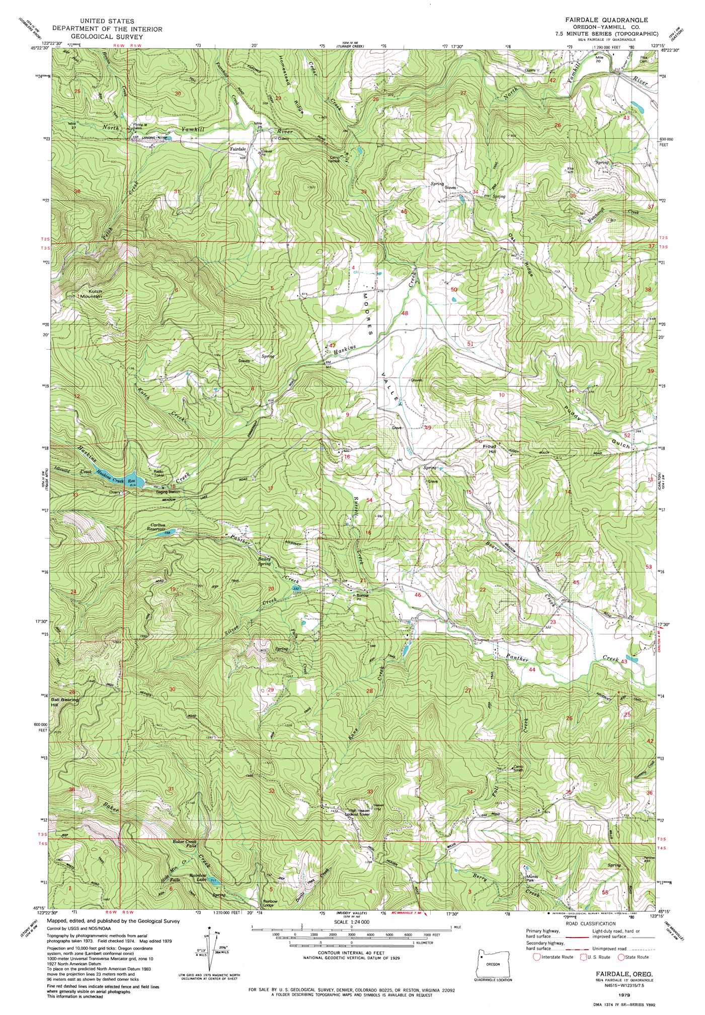
USGS Topo Quad 45123c3 - 1:24,000 scale
| Topo Map Name: | Fairdale |
| USGS Topo Quad ID: | 45123c3 |
| Print Size: | ca. 21 1/4" wide x 27" high |
| Southeast Coordinates: | 45.25° N latitude / 123.25° W longitude |
| Map Center Coordinates: | 45.3125° N latitude / 123.3125° W longitude |
| U.S. State: | OR |
| Filename: | o45123c3.jpg |
| Download Map JPG Image: | Fairdale topo map 1:24,000 scale |
| Map Type: | Topographic |
| Topo Series: | 7.5´ |
| Map Scale: | 1:24,000 |
| Source of Map Images: | United States Geological Survey (USGS) |
| Alternate Map Versions: |
Fairdale OR 1979, updated 1980 Download PDF Buy paper map Fairdale OR 1979, updated 1980 Download PDF Buy paper map Fairdale OR 2011 Download PDF Buy paper map Fairdale OR 2014 Download PDF Buy paper map |
1:24,000 Topo Quads surrounding Fairdale
Jordan Creek |
Wood Point |
Roaring Creek |
Gales Creek |
Forest Grove |
Trask |
Gobblers Knob |
Turner Creek |
Gaston |
Laurelwood |
Dovre Peak |
Trask Mountain |
Fairdale |
Carlton |
Dundee |
Springer Mountain |
Stony Mountain |
Muddy Valley |
Mcminnville |
Dayton |
Grand Ronde |
Sheridan |
Ballston |
Amity |
Mission Bottom |
> Back to 45123a1 at 1:100,000 scale
> Back to 45122a1 at 1:250,000 scale
> Back to U.S. Topo Maps home
Fairdale topo map: Gazetteer
Fairdale: Airports
Flying M Airstrip elevation 125m 410′Vons Airstrip elevation 69m 226′
Fairdale: Dams
Haskins Creek Dam elevation 232m 761′Panther Creek Dam elevation 132m 433′
Fairdale: Falls
Baker Creek Falls elevation 261m 856′Fairdale: Parks
Murray Park elevation 141m 462′Fairdale: Populated Places
Fairdale (historical) elevation 119m 390′Fairdale: Post Offices
Chesterbrook Post Office (historical) elevation 236m 774′Fairdale Post Office (historical) elevation 119m 390′
Manila Post Office (historical) elevation 278m 912′
Mountain House Post Office (historical) elevation 262m 859′
Fairdale: Reservoirs
Beltview Reservoir elevation 68m 223′Carlton Reservoir elevation 174m 570′
Flying M Reservoir elevation 124m 406′
Haskins Creek Reservoir elevation 251m 823′
Panther Creek Reservoir elevation 132m 433′
Rainbow Lake elevation 214m 702′
Turek Reservoir elevation 236m 774′
Vincent Pond elevation 108m 354′
Von Reservoir elevation 102m 334′
Fairdale: Ridges
Oak Ridge elevation 266m 872′Fairdale: Springs
Bailey Spring elevation 120m 393′Browns Spring elevation 184m 603′
Dawson Spring elevation 264m 866′
Fairdale Mineral Spring elevation 110m 360′
McCall Spring elevation 185m 606′
Fairdale: Streams
Beaver Creek elevation 51m 167′Bolton Creek elevation 121m 396′
Cedar Creek elevation 95m 311′
Fairchild Creek elevation 110m 360′
Fall Creek elevation 55m 180′
Falls Creek elevation 108m 354′
Hanna Creek elevation 127m 416′
Haskins Creek elevation 99m 324′
Idlewild Creek elevation 251m 823′
Kane Creek elevation 61m 200′
Kutch Creek elevation 195m 639′
Murray Creek elevation 86m 282′
Petch Creek elevation 121m 396′
Russel Creek elevation 83m 272′
Silver Creek elevation 98m 321′
Slide Mountain Creek elevation 234m 767′
Turner Creek elevation 62m 203′
Fairdale: Summits
Froud Hill elevation 235m 770′Kutch One Mountain elevation 626m 2053′
Fairdale: Valleys
Moores Valley elevation 113m 370′Puddy Gulch elevation 76m 249′
Fairdale digital topo map on disk
Buy this Fairdale topo map showing relief, roads, GPS coordinates and other geographical features, as a high-resolution digital map file on DVD: