Darland Mountain Topo Map Washington
To zoom in, hover over the map of Darland Mountain
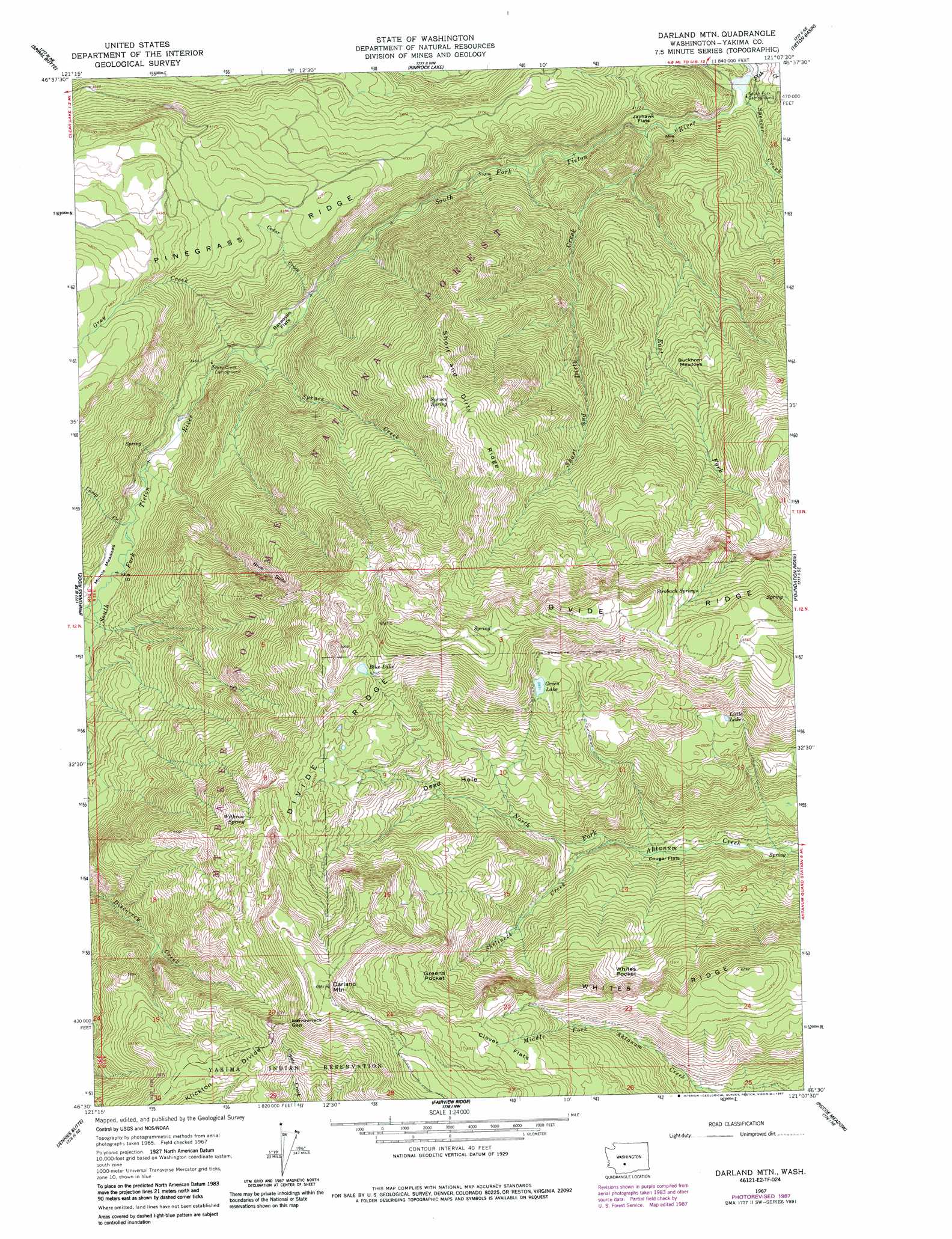
USGS Topo Quad 46121e2 - 1:24,000 scale
| Topo Map Name: | Darland Mountain |
| USGS Topo Quad ID: | 46121e2 |
| Print Size: | ca. 21 1/4" wide x 27" high |
| Southeast Coordinates: | 46.5° N latitude / 121.125° W longitude |
| Map Center Coordinates: | 46.5625° N latitude / 121.1875° W longitude |
| U.S. State: | WA |
| Filename: | o46121e2.jpg |
| Download Map JPG Image: | Darland Mountain topo map 1:24,000 scale |
| Map Type: | Topographic |
| Topo Series: | 7.5´ |
| Map Scale: | 1:24,000 |
| Source of Map Images: | United States Geological Survey (USGS) |
| Alternate Map Versions: |
Darland Mtn WA 1967, updated 1970 Download PDF Buy paper map Darland Mtn WA 1967, updated 1978 Download PDF Buy paper map Darland Mtn WA 1967, updated 1984 Download PDF Buy paper map Darland Mtn WA 1967, updated 1987 Download PDF Buy paper map Darland Mountain WA 2000, updated 2001 Download PDF Buy paper map Darland Mountain WA 2011 Download PDF Buy paper map Darland Mountain WA 2014 Download PDF Buy paper map |
| FStopo: | US Forest Service topo Darland Mountain is available: Download FStopo PDF Download FStopo TIF |
1:24,000 Topo Quads surrounding Darland Mountain
Cougar Lake |
Bumping Lake |
Timberwolf Mountain |
Meeks Table |
Nile |
White Pass |
Spiral Butte |
Rimrock Lake |
Tieton Basin |
Weddle Canyon |
Old Snowy Mountain |
Pinegrass Ridge |
Darland Mountain |
Foundation Ridge |
Pine Mountain |
Walupt Lake |
Jennies Butte |
Fairview Ridge |
Piscoe Meadow |
Yesmowit Canyon |
Glaciate Butte |
Windy Point |
Castile Falls |
Lost Horse Plateau |
Willy Dick Canyon |
> Back to 46121e1 at 1:100,000 scale
> Back to 46120a1 at 1:250,000 scale
> Back to U.S. Topo Maps home
Darland Mountain topo map: Gazetteer
Darland Mountain: Basins
Greens Pocket elevation 1767m 5797′Whites Pocket elevation 1691m 5547′
Darland Mountain: Bends
Dead Hole elevation 1637m 5370′Darland Mountain: Cliffs
Blue Slide elevation 1526m 5006′Darland Mountain: Flats
Bakeoven Flats elevation 1001m 3284′Buckhorn Meadows elevation 1309m 4294′
Clover Flats elevation 1934m 6345′
Cougar Flats elevation 1389m 4557′
Jayhawk Flats elevation 947m 3106′
Minnie Meadows elevation 1071m 3513′
Darland Mountain: Gaps
Narrowneck Gap elevation 1950m 6397′Darland Mountain: Lakes
Blue Lake elevation 1900m 6233′Green Lake elevation 1801m 5908′
Little Lake elevation 1720m 5643′
Darland Mountain: Ridges
Short and Dirty Ridge elevation 1703m 5587′Darland Mountain: Springs
Spruce Spring elevation 1711m 5613′Strobach Springs elevation 1985m 6512′
Withrow Spring elevation 1835m 6020′
Darland Mountain: Streams
Camp Creek elevation 1058m 3471′Cedar Creek elevation 1003m 3290′
Corral Creek elevation 1072m 3517′
East Fork Short and Dirty Creek elevation 986m 3234′
Fish Creek elevation 904m 2965′
Grey Creek elevation 1019m 3343′
Shellneck Creek elevation 1392m 4566′
Short and Dirty Creek elevation 913m 2995′
South Fork Tieton River elevation 903m 2962′
Spencer Creek elevation 897m 2942′
Spruce Creek elevation 1024m 3359′
Darland Mountain: Summits
Darland Mountain elevation 2122m 6961′Darland Mountain digital topo map on disk
Buy this Darland Mountain topo map showing relief, roads, GPS coordinates and other geographical features, as a high-resolution digital map file on DVD: