Windy Point Topo Map Washington
To zoom in, hover over the map of Windy Point
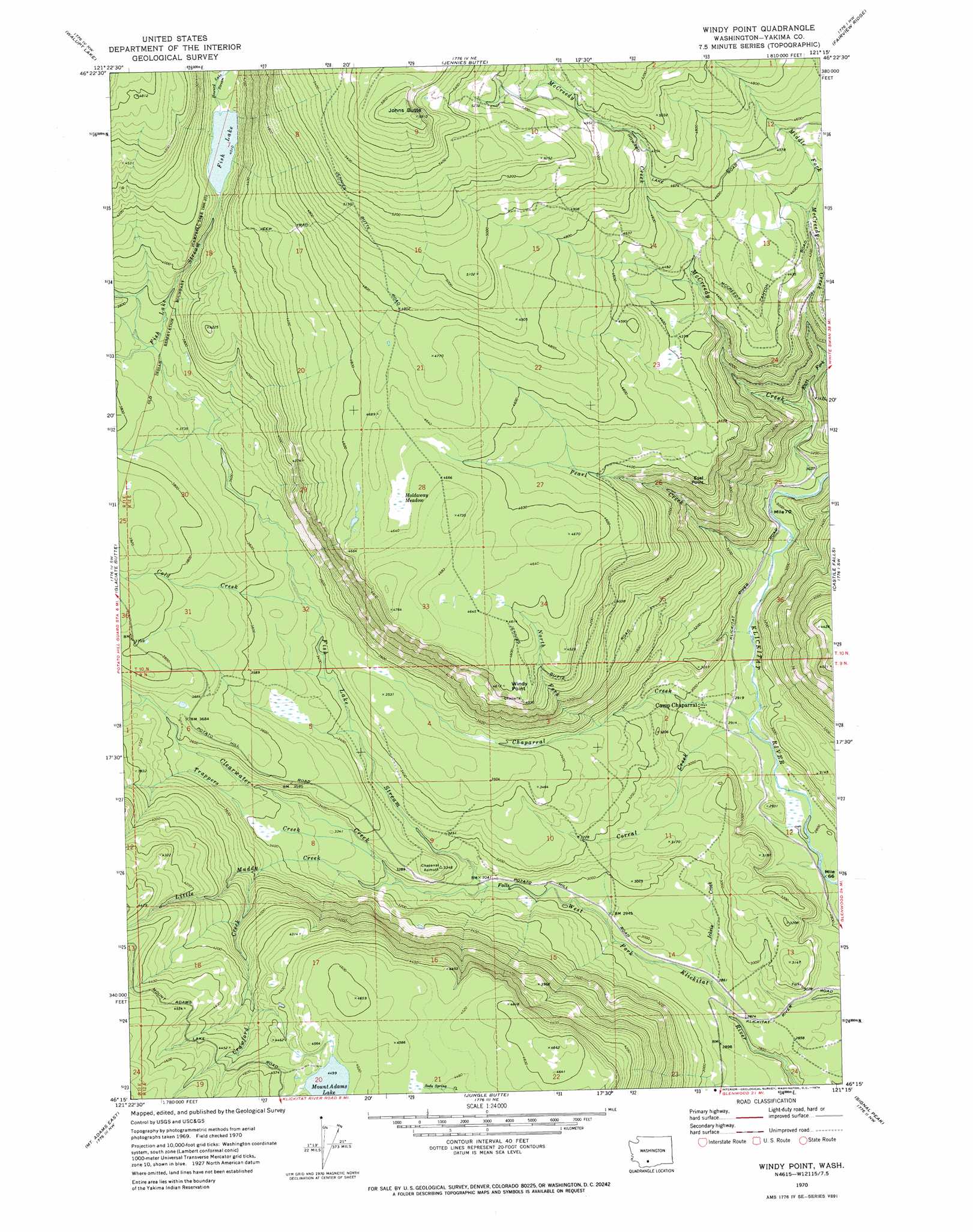
USGS Topo Quad 46121c3 - 1:24,000 scale
| Topo Map Name: | Windy Point |
| USGS Topo Quad ID: | 46121c3 |
| Print Size: | ca. 21 1/4" wide x 27" high |
| Southeast Coordinates: | 46.25° N latitude / 121.25° W longitude |
| Map Center Coordinates: | 46.3125° N latitude / 121.3125° W longitude |
| U.S. State: | WA |
| Filename: | o46121c3.jpg |
| Download Map JPG Image: | Windy Point topo map 1:24,000 scale |
| Map Type: | Topographic |
| Topo Series: | 7.5´ |
| Map Scale: | 1:24,000 |
| Source of Map Images: | United States Geological Survey (USGS) |
| Alternate Map Versions: |
Windy Point WA 1970, updated 1974 Download PDF Buy paper map Windy Point WA 2011 Download PDF Buy paper map Windy Point WA 2014 Download PDF Buy paper map |
1:24,000 Topo Quads surrounding Windy Point
Packwood Lake |
Old Snowy Mountain |
Pinegrass Ridge |
Darland Mountain |
Foundation Ridge |
Hamilton Buttes |
Walupt Lake |
Jennies Butte |
Fairview Ridge |
Piscoe Meadow |
Green Mountain |
Glaciate Butte |
Windy Point |
Castile Falls |
Lost Horse Plateau |
Mount Adams West |
Mount Adams East |
Jungle Butte |
Signal Peak |
Poland Butte |
Trout Lake |
King Mountain |
Glenwood |
Outlet Falls |
Twin Buttes |
> Back to 46121a1 at 1:100,000 scale
> Back to 46120a1 at 1:250,000 scale
> Back to U.S. Topo Maps home
Windy Point topo map: Gazetteer
Windy Point: Cliffs
Esel Point elevation 1307m 4288′Windy Point elevation 1406m 4612′
Windy Point: Flats
Holdaway Meadow elevation 1413m 4635′Windy Point: Lakes
Fish Lake elevation 1224m 4015′Mount Adams Lake elevation 1373m 4504′
Windy Point: Streams
Chaparral Creek elevation 868m 2847′Clearwater Creek elevation 943m 3093′
Cold Creek elevation 1060m 3477′
Corral Creek elevation 867m 2844′
Crawford Creek elevation 1072m 3517′
East Fork McCreedy Creek elevation 993m 3257′
Fish Lake Stream elevation 923m 3028′
Howard Lake Stream elevation 1224m 4015′
Icksix Creek elevation 864m 2834′
Little Muddy Creek elevation 987m 3238′
McCreedy Creek elevation 915m 3001′
Middle Fork McCreedy Creek elevation 1063m 3487′
North Fork Chaparral Creek elevation 1003m 3290′
Pearl Creek elevation 893m 2929′
Trappers Creek elevation 986m 3234′
Windy Point: Summits
Johns Butte elevation 1740m 5708′Windy Point digital topo map on disk
Buy this Windy Point topo map showing relief, roads, GPS coordinates and other geographical features, as a high-resolution digital map file on DVD: