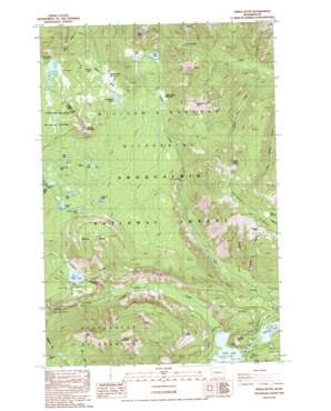
Spiral Butte Topo Map Washington
To zoom in, hover over the map of Spiral Butte
USGS Topo Quad 46121f3 - 1:24,000 scale
| Topo Map Name: | Spiral Butte |
| USGS Topo Quad ID: | 46121f3 |
| Print Size: | ca. 21 1/4" wide x 27" high |
| Southeast Coordinates: | 46.625° N latitude / 121.25° W longitude |
| Map Center Coordinates: | 46.6875° N latitude / 121.3125° W longitude |
| U.S. State: | WA |
| Filename: | o46121f3.jpg |
| Download Map JPG Image: | Spiral Butte topo map 1:24,000 scale |
| Map Type: | Topographic |
| Topo Series: | 7.5´ |
| Map Scale: | 1:24,000 |
| Source of Map Images: | United States Geological Survey (USGS) |
| Alternate Map Versions: |
Spiral Butte WA 1988, updated 1989 Download PDF Buy paper map Spiral Butte WA 1988, updated 1989 Download PDF Buy paper map Spiral Butte WA 2000, updated 2003 Download PDF Buy paper map Spiral Butte WA 2011 Download PDF Buy paper map Spiral Butte WA 2014 Download PDF Buy paper map |
| FStopo: | US Forest Service topo Spiral Butte is available: Download FStopo PDF Download FStopo TIF |
1:24,000 Topo Quads surrounding Spiral Butte
> Back to 46121e1 at 1:100,000 scale
> Back to 46120a1 at 1:250,000 scale
> Back to U.S. Topo Maps home
Spiral Butte topo map: Gazetteer
Spiral Butte: Dams
Clear Creek Dam elevation 910m 2985′Spiral Butte: Flats
Blankenship Meadows elevation 1581m 5187′Fox Meadow elevation 1738m 5702′
Indian Creek Meadows elevation 1505m 4937′
Spiral Butte: Lakes
Apple Lake elevation 1548m 5078′Art Lake elevation 1597m 5239′
Blakenship Lakes elevation 1606m 5269′
Cramer Lake elevation 1533m 5029′
Dancing Lady Lake elevation 1523m 4996′
Dog Lake elevation 1284m 4212′
Hill Lake elevation 1560m 5118′
Long John Lake elevation 1571m 5154′
Otter Lake elevation 1536m 5039′
Pear Lake elevation 1549m 5082′
Pillar Lake elevation 1609m 5278′
Round Lake elevation 1568m 5144′
Shellrock Lake elevation 1503m 4931′
Summit Lakes elevation 1582m 5190′
Spiral Butte: Pillars
Bootjack Rock elevation 1794m 5885′Spiral Butte: Reservoirs
Clear Lake elevation 910m 2985′Spiral Butte: Ridges
Sand Ridge elevation 1417m 4648′Spiral Butte: Springs
Indian Spring elevation 1310m 4297′Spiral Butte: Streams
Clear Creek elevation 913m 2995′Cold Creek elevation 900m 2952′
McNeil Creek elevation 1213m 3979′
Muddy Creek elevation 966m 3169′
North Fork Clear Creek elevation 1029m 3375′
North Fork Tieton River elevation 894m 2933′
South Fork Clear Creek elevation 1031m 3382′
Spiral Butte: Summits
Arnesons Peak elevation 1945m 6381′Ironstone Mountain elevation 1961m 6433′
Kamiakan Butte elevation 1065m 3494′
McNeil Peak elevation 2024m 6640′
Pear Butte elevation 1946m 6384′
Round Mountain elevation 1817m 5961′
Spiral Butte elevation 1601m 5252′
Tumac Mountain elevation 1916m 6286′
Twin Peaks elevation 1760m 5774′
Spiral Butte: Trails
Big Peak Trail elevation 1661m 5449′Blankenship Meadows Trail elevation 1490m 4888′
Cramer Lake Trail elevation 1500m 4921′
Hogback Trail elevation 1600m 5249′
Indian Creek Trail elevation 1630m 5347′
Ironstone Mountain Trail elevation 1821m 5974′
Little Wildcat Trail elevation 1567m 5141′
McAllister Trail elevation 1419m 4655′
Rattlesnake Trail elevation 1608m 5275′
Sand Ridge Trail elevation 1493m 4898′
Shellrock Lake Trail elevation 1483m 4865′
Twin Sisters Trail elevation 1445m 4740′
Spiral Butte: Valleys
Mosquito Valley elevation 1433m 4701′Spiral Butte digital topo map on disk
Buy this Spiral Butte topo map showing relief, roads, GPS coordinates and other geographical features, as a high-resolution digital map file on DVD:


