Kelso Topo Map Washington
To zoom in, hover over the map of Kelso
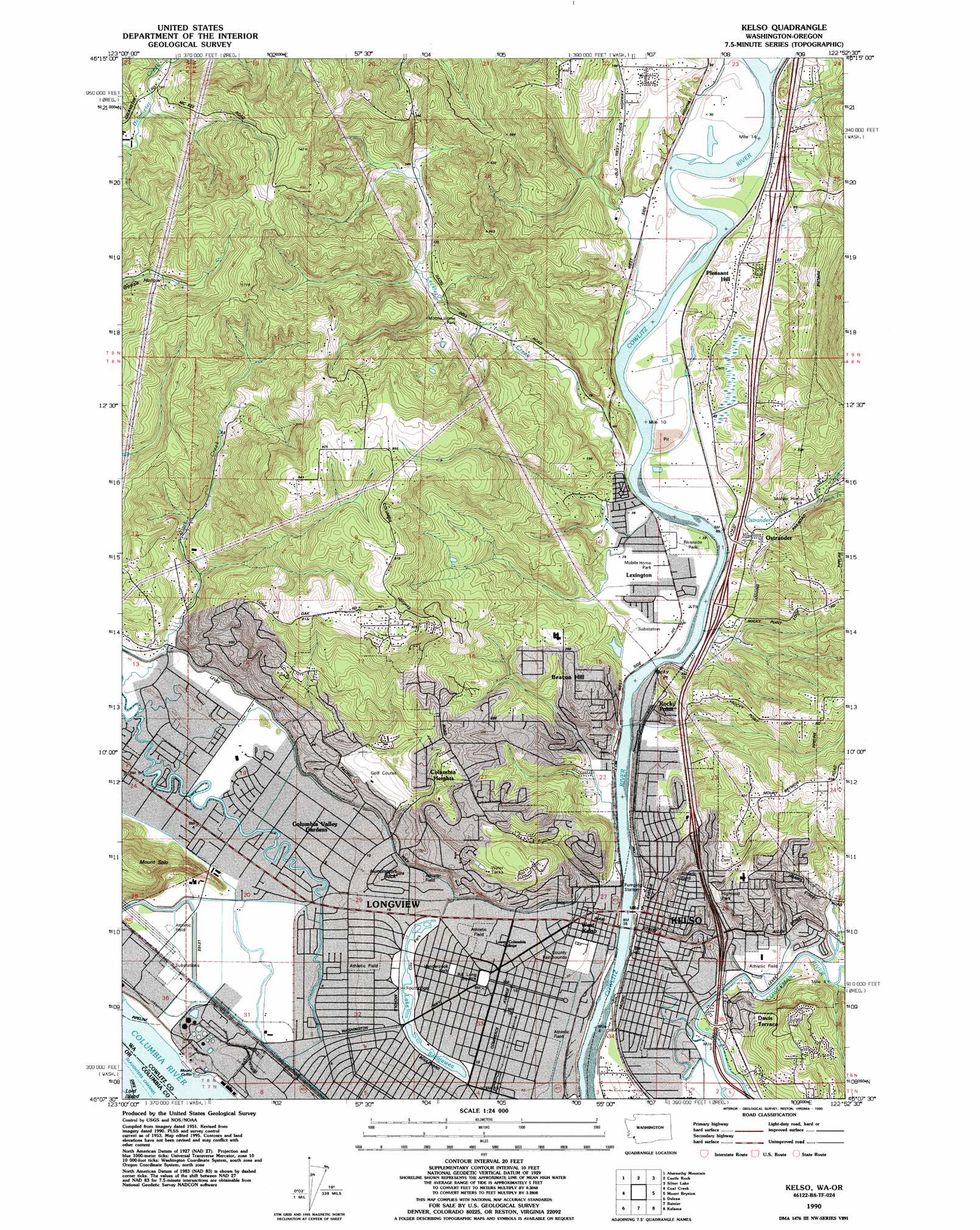
USGS Topo Quad 46122b8 - 1:24,000 scale
| Topo Map Name: | Kelso |
| USGS Topo Quad ID: | 46122b8 |
| Print Size: | ca. 21 1/4" wide x 27" high |
| Southeast Coordinates: | 46.125° N latitude / 122.875° W longitude |
| Map Center Coordinates: | 46.1875° N latitude / 122.9375° W longitude |
| U.S. States: | WA, OR |
| Filename: | o46122b8.jpg |
| Download Map JPG Image: | Kelso topo map 1:24,000 scale |
| Map Type: | Topographic |
| Topo Series: | 7.5´ |
| Map Scale: | 1:24,000 |
| Source of Map Images: | United States Geological Survey (USGS) |
| Alternate Map Versions: |
Kelso WA 1953, updated 1955 Download PDF Buy paper map Kelso WA 1953, updated 1967 Download PDF Buy paper map Kelso WA 1953, updated 1971 Download PDF Buy paper map Kelso WA 1990, updated 1995 Download PDF Buy paper map Kelso WA 2011 Download PDF Buy paper map Kelso WA 2013 Download PDF Buy paper map |
1:24,000 Topo Quads surrounding Kelso
Boistfort Peak |
Wildwood |
Winlock |
Toledo |
Eden Valley |
Elochoman Lake |
Abernathy Mountain |
Castle Rock |
Silver Lake |
Toutle |
Oak Point |
Coal Creek |
Kelso |
Mount Brynion |
Hemlock Pass |
Clatskanie |
Delena |
Rainier |
Kalama |
Woolford Creek |
Pittsburg |
Baker Point |
Trenholm |
Deer Island |
Woodland |
> Back to 46122a1 at 1:100,000 scale
> Back to 46122a1 at 1:250,000 scale
> Back to U.S. Topo Maps home
Kelso topo map: Gazetteer
Kelso: Airports
Monticello Medical Center Heliport elevation 7m 22′Kelso: Dams
Cedar Street Reservoir Dam elevation 90m 295′Kelso: Guts
Ditch Number Five elevation 5m 16′Kelso: Lakes
Lake Sacajawea elevation 3m 9′Kelso: Parks
Highland Park elevation 12m 39′Lake Sacajawea Park elevation 3m 9′
R A Long Square elevation 5m 16′
Riverside County Park elevation 7m 22′
Vandercook Park elevation 5m 16′
Kelso: Pillars
Huntington Rock elevation 9m 29′Kelso: Populated Places
Beacon Hill elevation 83m 272′Columbia Heights elevation 107m 351′
Columbia Valley Gardens elevation 5m 16′
Davis Terrace elevation 20m 65′
Evergreen Terrace elevation 29m 95′
Kelso elevation 23m 75′
Lexington elevation 9m 29′
Longview elevation 6m 19′
Longview Heights elevation 270m 885′
Monticello (historical) elevation 6m 19′
Ostrander elevation 30m 98′
Pleasant Hill elevation 33m 108′
Rocky Point elevation 20m 65′
Sandy Bend elevation 51m 167′
Valley View Tracts elevation 131m 429′
West Kelso elevation 7m 22′
West Longview elevation 4m 13′
Kelso: Reservoirs
Cedar Street Reservoir elevation 90m 295′Kelso: Streams
Clark Creek elevation 6m 19′Leckler Creek elevation 7m 22′
Ostrander Creek elevation 7m 22′
Sandy Bend Creek elevation 7m 22′
South Fork Ostrander Creek elevation 14m 45′
Kelso: Summits
Mount Coffin elevation 7m 22′Mount Solo elevation 184m 603′
Rocky Point elevation 78m 255′
Kelso digital topo map on disk
Buy this Kelso topo map showing relief, roads, GPS coordinates and other geographical features, as a high-resolution digital map file on DVD: