Stipek Topo Map Montana
To zoom in, hover over the map of Stipek
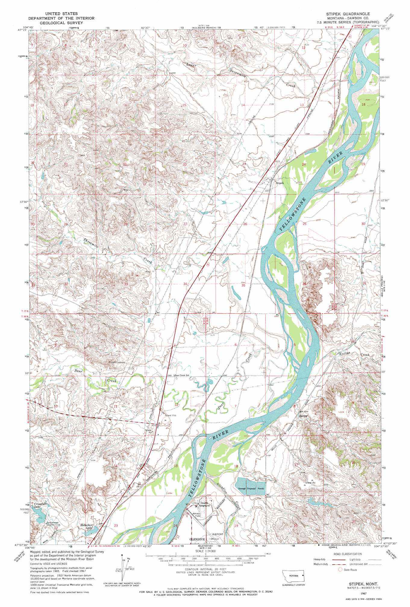
USGS Topo Quad 47104b6 - 1:24,000 scale
| Topo Map Name: | Stipek |
| USGS Topo Quad ID: | 47104b6 |
| Print Size: | ca. 21 1/4" wide x 27" high |
| Southeast Coordinates: | 47.125° N latitude / 104.625° W longitude |
| Map Center Coordinates: | 47.1875° N latitude / 104.6875° W longitude |
| U.S. State: | MT |
| Filename: | o47104b6.jpg |
| Download Map JPG Image: | Stipek topo map 1:24,000 scale |
| Map Type: | Topographic |
| Topo Series: | 7.5´ |
| Map Scale: | 1:24,000 |
| Source of Map Images: | United States Geological Survey (USGS) |
| Alternate Map Versions: |
Stipek MT 1967, updated 1970 Download PDF Buy paper map Stipek MT 2011 Download PDF Buy paper map Stipek MT 2014 Download PDF Buy paper map |
1:24,000 Topo Quads surrounding Stipek
Bloomfield |
Red Top |
Intake Nw |
Allard Ranch |
Knife River Mine |
Stinking Coulee |
Morgan Creek School |
Kolberg Ranch |
Intake |
Savage Sw |
Poverty Flat West |
Poverty Flat East |
Stipek |
Belle Prairie |
Cluster Buttes Nw |
Pleasant View |
Forest Park |
Glendive |
Allard |
Cluster Buttes Sw |
Marsh |
Hoyt |
Upper Magpie Reservoir |
Twin Forks Reservoir |
Hodges |
> Back to 47104a1 at 1:100,000 scale
> Back to 47104a1 at 1:250,000 scale
> Back to U.S. Topo Maps home
Stipek topo map: Gazetteer
Stipek: Airports
Glendive Airport (historical) elevation 648m 2125′Stipek: Dams
Cottonwood Country Club Dam elevation 656m 2152′Glendive Sewage Disposal Ponds Dam elevation 644m 2112′
Guelff Dam elevation 667m 2188′
Hollecker Dam elevation 632m 2073′
Pettersen Number 1 Dam elevation 628m 2060′
Stipek: Islands
Schaffer Island elevation 613m 2011′Stipek: Parks
Hollecker Park elevation 631m 2070′Meissner American Legion Baseball Field elevation 646m 2119′
Stipek: Populated Places
Stipek elevation 623m 2043′Stipek: Post Offices
Nolton Post Office (historical) elevation 647m 2122′Stipek Post Office (historical) elevation 622m 2040′
Stipek: Reservoirs
Crisafulli Lake elevation 653m 2142′Hollecker Lake elevation 637m 2089′
Hollecker Reservoir elevation 632m 2073′
Stipek: Streams
Cotton Creek elevation 615m 2017′Crisafulli Creek elevation 621m 2037′
Deer Creek elevation 625m 2050′
Glendive Creek elevation 620m 2034′
Lower Sevenmile Creek elevation 610m 2001′
Threemile School (historical) elevation 623m 2043′
Stipek: Summits
Bryants Buttes elevation 742m 2434′Custers Lookout elevation 719m 2358′
Stipek: Wells
15N55E23ACC_01 Well elevation 623m 2043′16N55E01DC__01 Well elevation 631m 2070′
16N55E01DD__01 Well elevation 627m 2057′
16N55E02DC__01 Well elevation 639m 2096′
16N55E10BCBD01 Well elevation 673m 2208′
16N55E12ABAA01 Well elevation 630m 2066′
16N55E12BB__01 Well elevation 643m 2109′
16N55E12BD__01 Well elevation 631m 2070′
16N55E12CCBB01 Well elevation 649m 2129′
16N55E13BD__01 Well elevation 627m 2057′
16N55E14AD__01 Well elevation 640m 2099′
16N55E14DADD01 Well elevation 641m 2103′
16N55E22DDD_01 Well elevation 620m 2034′
16N55E23AC__01 Well elevation 620m 2034′
16N55E23CDC_01 Well elevation 621m 2037′
16N56E06CA__01 Well elevation 624m 2047′
16N56E06DB__01 Well elevation 623m 2043′
16N56E07BBBC01 Well elevation 624m 2047′
16N56E08AABD01 Well elevation 625m 2050′
16N56E20BB__01 Well elevation 659m 2162′
16N56E20CBAC01 Well elevation 672m 2204′
17N55E12DADC01 Well elevation 634m 2080′
17N55E13AA__01 Well elevation 626m 2053′
17N55E23AB__01 Well elevation 642m 2106′
17N55E23BC__01 Well elevation 655m 2148′
17N55E23CDDC01 Well elevation 627m 2057′
17N55E23DA__01 Well elevation 629m 2063′
17N55E23DACC01 Well elevation 628m 2060′
17N55E23DCBA01 Well elevation 626m 2053′
17N55E23DD__01 Well elevation 624m 2047′
17N55E26BBAC01 Well elevation 634m 2080′
17N55E34AD__01 Well elevation 639m 2096′
17N55E34DBDD01 Well elevation 651m 2135′
17N55E34DD__01 Well elevation 655m 2148′
17N55E34DD__02 Well elevation 655m 2148′
17N55E35AB__01 Well elevation 622m 2040′
17N56E31CC__01 Well elevation 674m 2211′
Stipek digital topo map on disk
Buy this Stipek topo map showing relief, roads, GPS coordinates and other geographical features, as a high-resolution digital map file on DVD:
Eastern Montana & Western North Dakota
Buy digital topo maps: Eastern Montana & Western North Dakota