Merino Topo Map Montana
To zoom in, hover over the map of Merino
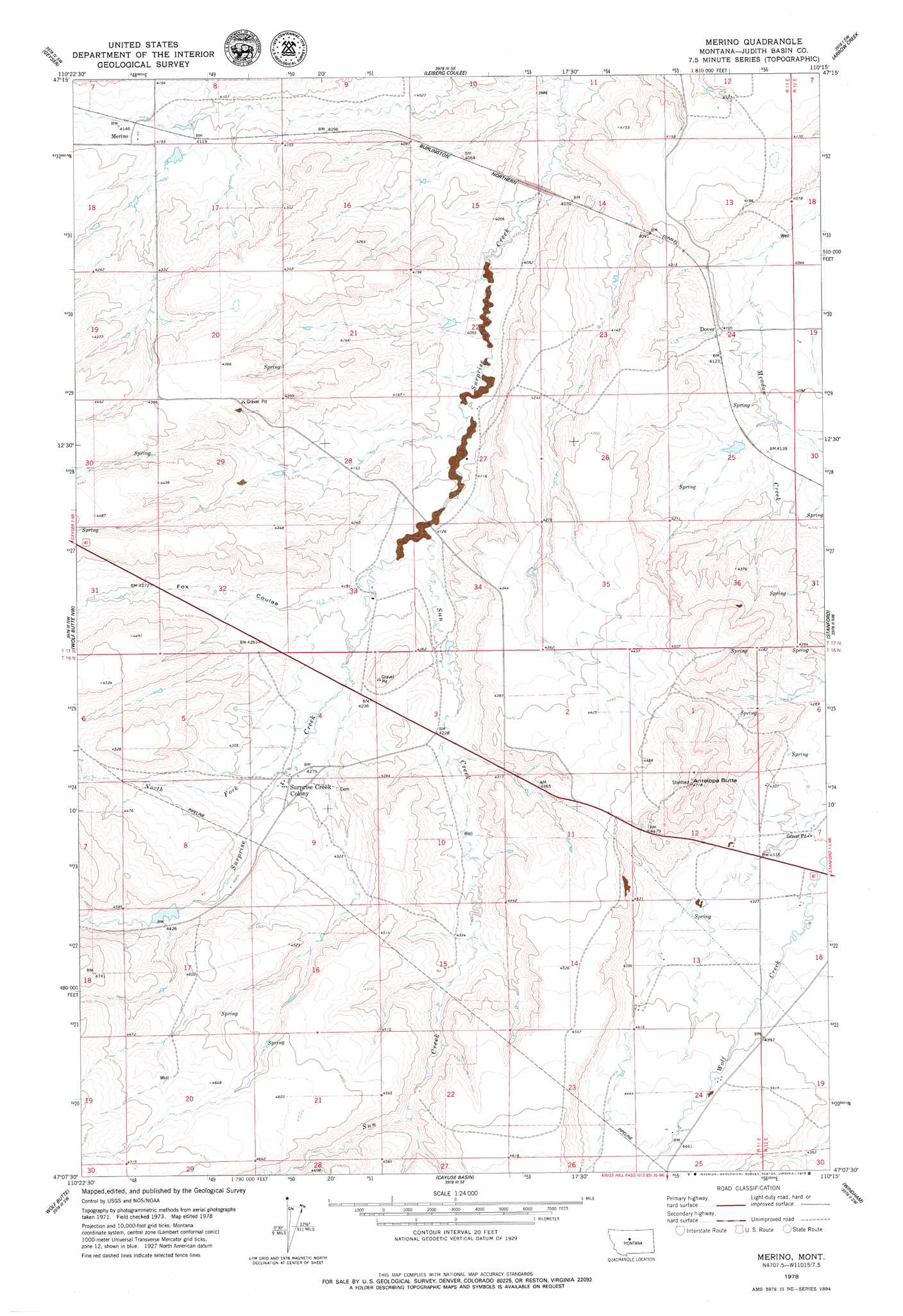
USGS Topo Quad 47110b3 - 1:24,000 scale
| Topo Map Name: | Merino |
| USGS Topo Quad ID: | 47110b3 |
| Print Size: | ca. 21 1/4" wide x 27" high |
| Southeast Coordinates: | 47.125° N latitude / 110.25° W longitude |
| Map Center Coordinates: | 47.1875° N latitude / 110.3125° W longitude |
| U.S. State: | MT |
| Filename: | o47110b3.jpg |
| Download Map JPG Image: | Merino topo map 1:24,000 scale |
| Map Type: | Topographic |
| Topo Series: | 7.5´ |
| Map Scale: | 1:24,000 |
| Source of Map Images: | United States Geological Survey (USGS) |
| Alternate Map Versions: |
Merino MT 1978, updated 1979 Download PDF Buy paper map Merino MT 2011 Download PDF Buy paper map Merino MT 2014 Download PDF Buy paper map |
1:24,000 Topo Quads surrounding Merino
Arrow Peak |
Palisade Butte |
Jiggs Flat |
Pownal |
Strouf Island |
Byrne Creek |
Geyser |
Leiberg Coulee |
Arrow Creek |
Coffee Creek |
The Arch |
Wolf Butte Nw |
Merino |
Stanford |
Stanford Ne |
Mixes Baldy |
Wolf Butte |
Cayuse Basin |
Windham |
Benchland |
Yogo Peak |
Band Box Mountain |
Woodhurst Mountain |
Red Hill |
Utica |
> Back to 47110a1 at 1:100,000 scale
> Back to 47110a1 at 1:250,000 scale
> Back to U.S. Topo Maps home
Merino topo map: Gazetteer
Merino: Dams
Wendall Willkie Dam elevation 1256m 4120′Wilson Dam elevation 1354m 4442′
Merino: Populated Places
Dover elevation 1257m 4124′Merino elevation 1266m 4153′
Surprise Creek Colony elevation 1307m 4288′
Merino: Post Offices
Dover Post Office (historical) elevation 1258m 4127′Merino Post Office (historical) elevation 1266m 4153′
Merino: Springs
16N11E02DD__01 Spring elevation 1367m 4484′16N11E04BB__01 Spring elevation 1314m 4311′
16N11E16AC__01 Spring elevation 1394m 4573′
16N11E16CB__01 Spring elevation 1391m 4563′
16N11E17BA__01 Spring elevation 1362m 4468′
16N11E17BB__01 Spring elevation 1381m 4530′
16N11E23AD__01 Spring elevation 1358m 4455′
16N11E23CA__01 Spring elevation 1405m 4609′
16N12E07CA__01 Spring elevation 1315m 4314′
16N12E07CB__01 Spring elevation 1317m 4320′
16N12E07CB__02 Spring elevation 1317m 4320′
16N12E18CC__01 Spring elevation 1341m 4399′
17N11E18DA__01 Spring elevation 1269m 4163′
17N11E25AB__01 Spring elevation 1255m 4117′
17N11E28CD__01 Spring elevation 1312m 4304′
17N11E29DB__01 Spring elevation 1308m 4291′
17N11E30AD__01 Spring elevation 1345m 4412′
Merino: Streams
North Fork Surprise Creek elevation 1300m 4265′Sun Creek elevation 1256m 4120′
Merino: Summits
Antelope Butte elevation 1438m 4717′Merino: Valleys
Fox Coulee elevation 1267m 4156′Merino: Wells
16N11E02CB__01 Well elevation 1344m 4409′16N11E04CD__01 Well elevation 1305m 4281′
16N11E04CD__02 Well elevation 1308m 4291′
16N11E04CDDC01 Well elevation 1307m 4288′
16N11E10AC__01 Well elevation 1309m 4294′
16N11E12AA__01 Well elevation 1324m 4343′
16N11E12AD__01 Well elevation 1318m 4324′
16N11E13A___01 Well elevation 1330m 4363′
16N11E13BB__01 Well elevation 1335m 4379′
16N11E13CC__01 Well elevation 1347m 4419′
16N11E20BD__01 Well elevation 1426m 4678′
16N11E24____01 Well elevation 1355m 4445′
16N11E24A___01 Well elevation 1350m 4429′
16N12E07BB__01 Well elevation 1315m 4314′
16N12E07BB__02 Well elevation 1315m 4314′
16N12E07DC__01 Well elevation 1318m 4324′
16N12E07DC__02 Well elevation 1318m 4324′
16N12E18BA__01 Well elevation 1321m 4333′
17N11E07DD__01 Well elevation 1267m 4156′
17N11E08DA__01 Well elevation 1244m 4081′
17N11E12DB__01 Well elevation 1253m 4110′
17N11E18AA__01 Well elevation 1281m 4202′
17N11E23BD__01 Well elevation 1267m 4156′
17N11E27BA__01 Well elevation 1247m 4091′
17N11E27CAAB01 Well elevation 1248m 4094′
17N11E33AC__01 Well elevation 1272m 4173′
17N11E33DB__01 Well elevation 1278m 4192′
17N11E33DD__01 Well elevation 1297m 4255′
17N12E19CB__01 Well elevation 1244m 4081′
Merino digital topo map on disk
Buy this Merino topo map showing relief, roads, GPS coordinates and other geographical features, as a high-resolution digital map file on DVD: