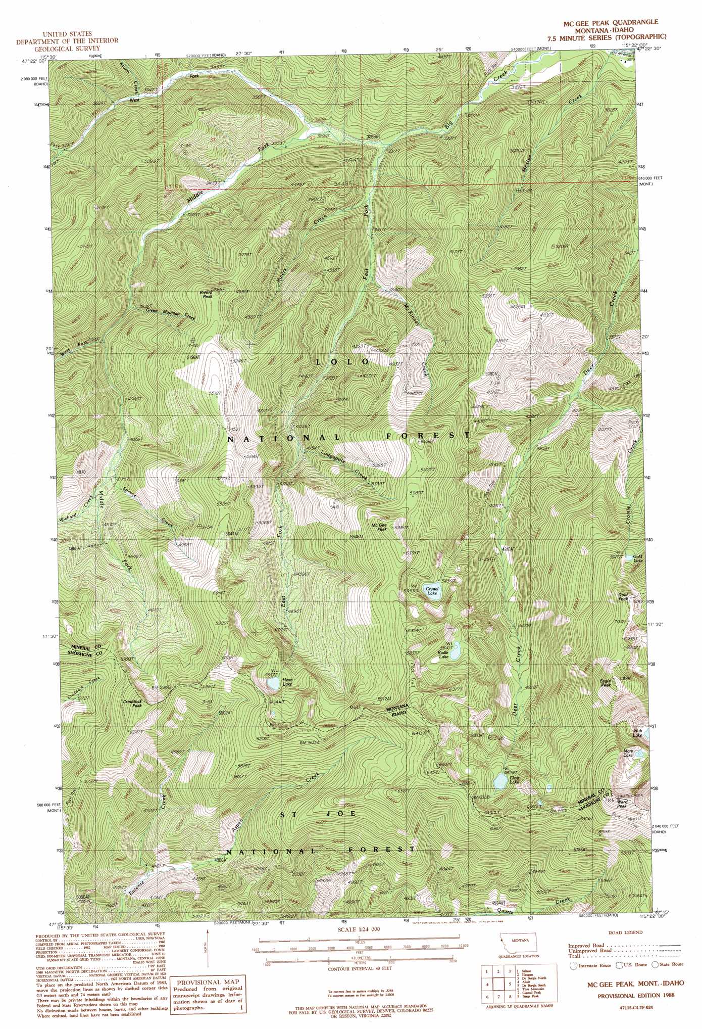
Mcgee Peak Topo Map Montana
To zoom in, hover over the map of Mcgee Peak
USGS Topo Quad 47115c4 - 1:24,000 scale
| Topo Map Name: | Mcgee Peak |
| USGS Topo Quad ID: | 47115c4 |
| Print Size: | ca. 21 1/4" wide x 27" high |
| Southeast Coordinates: | 47.25° N latitude / 115.375° W longitude |
| Map Center Coordinates: | 47.3125° N latitude / 115.4375° W longitude |
| U.S. States: | MT, ID |
| Filename: | o47115c4.jpg |
| Download Map JPG Image: | Mcgee Peak topo map 1:24,000 scale |
| Map Type: | Topographic |
| Topo Series: | 7.5´ |
| Map Scale: | 1:24,000 |
| Source of Map Images: | United States Geological Survey (USGS) |
| Alternate Map Versions: |
McGee Peak MT 1988, updated 1988 Download PDF Buy paper map McGee Peak MT 1999, updated 2003 Download PDF Buy paper map McGee Peak MT 2011 Download PDF Buy paper map McGee Peak MT 2014 Download PDF Buy paper map |
| FStopo: | US Forest Service topo McGee Peak is available: Download FStopo PDF Download FStopo TIF |
1:24,000 Topo Quads surrounding Mcgee Peak
Thompson Pass |
Driveway Peak |
Table Top Mountain |
Thompson Falls |
Eddy Mountain |
Lookout Pass |
Saltese |
Haugan |
Deborgia North |
Penrose Peak |
Shefoot Mountain |
Adair |
Mcgee Peak |
Deborgia South |
Boyd Mountain |
Three Sisters |
Thor Mountain |
Conrad Peak |
Berge Peak |
Torino Peak |
Montana Peak |
Bathtub Mountain |
Peggy Peak |
Red Ives Peak |
Sherlock Peak |
> Back to 47115a1 at 1:100,000 scale
> Back to 47114a1 at 1:250,000 scale
> Back to U.S. Topo Maps home
Mcgee Peak topo map: Gazetteer
Mcgee Peak: Lakes
Clear Lake elevation 1779m 5836′Crystal Lake elevation 1668m 5472′
Gold Lake elevation 1828m 5997′
Heart Lake elevation 1691m 5547′
Hub Lake elevation 1741m 5711′
Mary Lake elevation 1951m 6400′
Rudie Lake elevation 1726m 5662′
Mcgee Peak: Mines
Big Creek Mine elevation 1460m 4790′Gold Chrome Mine elevation 1090m 3576′
Minnick Mine elevation 1229m 4032′
Mcgee Peak: Streams
Aspen Creek elevation 1255m 4117′Cromie Creek elevation 1119m 3671′
East Fork Big Creek elevation 997m 3270′
Gilt Edge Creek elevation 1146m 3759′
Green Mountain Creek elevation 1128m 3700′
Green Mountain Creek elevation 1126m 3694′
Lodgepole Creek elevation 1237m 4058′
McKinney Creek elevation 1057m 3467′
Middle Fork Big Creek elevation 1010m 3313′
Rivers Creek elevation 1019m 3343′
Spruce Creek elevation 1244m 4081′
Storm Creek elevation 1092m 3582′
Up Up Creek elevation 1057m 3467′
West Fork Big Creek elevation 997m 3270′
West Fork Middle Fork Big Creek elevation 1161m 3809′
Wishard Creek elevation 1280m 4199′
Mcgee Peak: Summits
Craddock Peak elevation 1917m 6289′Eagle Peak elevation 2206m 7237′
Gold Peak elevation 2142m 7027′
McGee Peak elevation 1925m 6315′
Rivers Peak elevation 1611m 5285′
Ward Peak elevation 2201m 7221′
Ward Peak elevation 2218m 7276′
Mcgee Peak digital topo map on disk
Buy this Mcgee Peak topo map showing relief, roads, GPS coordinates and other geographical features, as a high-resolution digital map file on DVD: