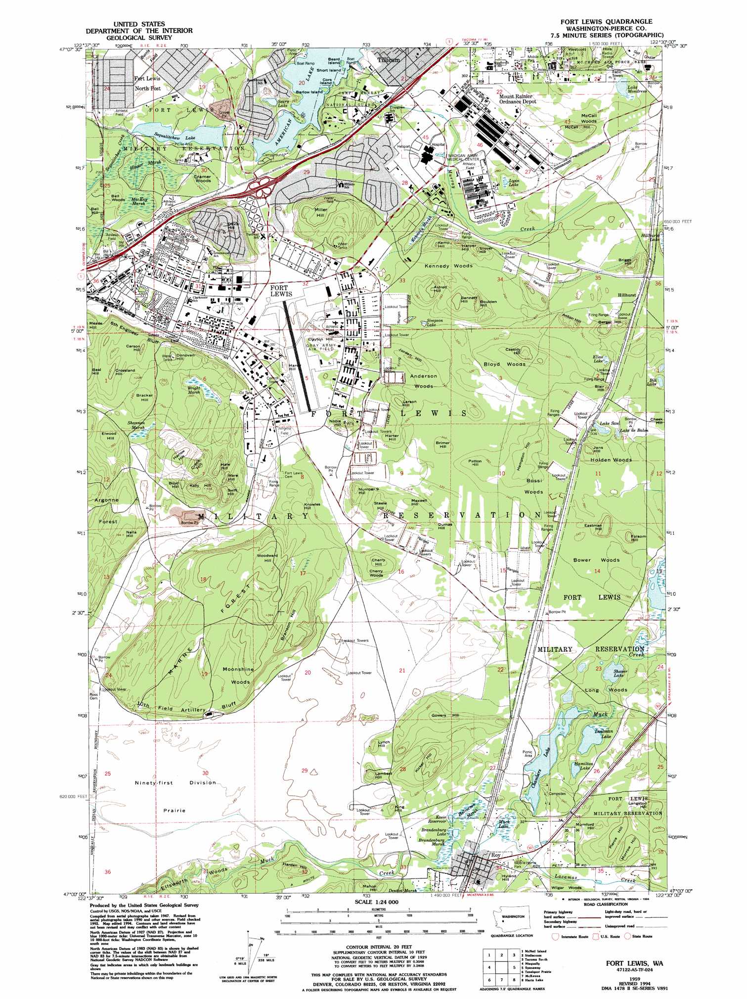
Fort Lewis Topo Map Washington
To zoom in, hover over the map of Fort Lewis
USGS Topo Quad 47122a5 - 1:24,000 scale
| Topo Map Name: | Fort Lewis |
| USGS Topo Quad ID: | 47122a5 |
| Print Size: | ca. 21 1/4" wide x 27" high |
| Southeast Coordinates: | 47° N latitude / 122.5° W longitude |
| Map Center Coordinates: | 47.0625° N latitude / 122.5625° W longitude |
| U.S. State: | WA |
| Filename: | o47122a5.jpg |
| Download Map JPG Image: | Fort Lewis topo map 1:24,000 scale |
| Map Type: | Topographic |
| Topo Series: | 7.5´ |
| Map Scale: | 1:24,000 |
| Source of Map Images: | United States Geological Survey (USGS) |
| Alternate Map Versions: |
Fort Lewis WA 1948, updated 1955 Download PDF Buy paper map Fort Lewis WA 1959, updated 1966 Download PDF Buy paper map Fort Lewis WA 1959, updated 1973 Download PDF Buy paper map Fort Lewis WA 1959, updated 1976 Download PDF Buy paper map Fort Lewis WA 1959, updated 1994 Download PDF Buy paper map Fort Lewis WA 1997, updated 2003 Download PDF Buy paper map Fort Lewis WA 2011 Download PDF Buy paper map Fort Lewis WA 2014 Download PDF Buy paper map |
1:24,000 Topo Quads surrounding Fort Lewis
Vaughn |
Fox Island |
Gig Harbor |
Tacoma North |
Poverty Bay |
Longbranch |
Mcneil Island |
Steilacoom |
Tacoma South |
Puyallup |
Lacey |
Nisqually |
Fort Lewis |
Spanaway |
Frederickson |
East Olympia |
Tenalquot Prarie |
Mckenna |
Harts Lake |
Tanwax Lake |
Bucoda |
Vail |
Lake Lawrence |
Bald Hill |
Eatonville |
> Back to 47122a1 at 1:100,000 scale
> Back to 47122a1 at 1:250,000 scale
> Back to U.S. Topo Maps home
Fort Lewis topo map: Gazetteer
Fort Lewis: Airports
Madigan Hospital Heliport elevation 86m 282′Fort Lewis: Cliffs
Sixth Engineer Bluff elevation 115m 377′Tenth Field Artillery Bluff elevation 105m 344′
Fort Lewis: Crossings
Interchange 119 elevation 77m 252′Interchange 120 elevation 82m 269′
Interchange 122 elevation 84m 275′
Fort Lewis: Dams
Chambers Lake Dam elevation 99m 324′Johnson Marsh Dam elevation 105m 344′
Fort Lewis: Flats
American Prairie elevation 73m 239′Ninety-first Division Prairie elevation 83m 272′
Fort Lewis: Islands
Barlow Island elevation 71m 232′Beard Island elevation 71m 232′
Cors Island elevation 71m 232′
Short Island elevation 71m 232′
Fort Lewis: Lakes
Bill Lake elevation 105m 344′Dailman Lake elevation 97m 318′
Hamilton Lake elevation 97m 318′
Hillhurst Lake elevation 89m 291′
Lake de Balon elevation 96m 314′
Lake Elias elevation 98m 321′
Lake Mondress elevation 86m 282′
Lake Saul elevation 98m 321′
Lynn Lake elevation 86m 282′
Muck Lake elevation 98m 321′
Sears Lake elevation 74m 242′
Sequalitchew Lake elevation 67m 219′
Shaver Lake elevation 97m 318′
Simpson Lake elevation 92m 301′
Fort Lewis: Populated Places
American Lake Garden Tract elevation 86m 282′Hillhurst elevation 103m 337′
Hillside elevation 85m 278′
Roy elevation 98m 321′
Tillicum elevation 84m 275′
Fort Lewis: Ranges
Westcott Hills elevation 102m 334′Fort Lewis: Reservoirs
Chambers Lake elevation 99m 324′Johnson Marsh elevation 105m 344′
Fort Lewis: Streams
Lacamas Creek elevation 98m 321′Murray Creek elevation 75m 246′
Fort Lewis: Summits
Aldred Hill elevation 123m 403′Anton Hill elevation 120m 393′
Bell Hill elevation 83m 272′
Bennett Hill elevation 125m 410′
Berger Hill elevation 128m 419′
Blair Hill elevation 120m 393′
Boulden Hill elevation 129m 423′
Boyd Hill elevation 126m 413′
Bracker Hill elevation 114m 374′
Branson Hill elevation 130m 426′
Briggs Hill elevation 124m 406′
Brimer Hill elevation 105m 344′
Carson Hill elevation 123m 403′
Cassidy Hill elevation 132m 433′
Cheek Hill elevation 111m 364′
Cherry Hill elevation 113m 370′
Clayton Hill elevation 110m 360′
Crook Hill elevation 124m 406′
Crossland Hill elevation 124m 406′
Davis Hill elevation 118m 387′
Donovan Hill elevation 124m 406′
Dumas Hill elevation 105m 344′
Eastman Hill elevation 132m 433′
Elwood Hill elevation 116m 380′
Folsom Hill elevation 132m 433′
Gowers Hill elevation 118m 387′
Hale Hill elevation 129m 423′
Hampton Hill elevation 118m 387′
Harden Hill elevation 117m 383′
Hardy Hill elevation 105m 344′
Harlow Hill elevation 125m 410′
Harper Hill elevation 121m 396′
Harter Hill elevation 106m 347′
Hyland Hill elevation 118m 387′
Jans Hill elevation 126m 413′
Jorden Hill elevation 118m 387′
Kelly Hill elevation 137m 449′
Kemp Hill elevation 119m 390′
Kicker Hill elevation 130m 426′
King Hill elevation 112m 367′
Knowles Hill elevation 114m 374′
Lambert Hill elevation 120m 393′
Langston Hill elevation 130m 426′
Larson Hill elevation 125m 410′
Lynch Hill elevation 112m 367′
Mahon Hill elevation 112m 367′
Maxwell Hill elevation 107m 351′
McCall Hill elevation 104m 341′
Miller Hill elevation 132m 433′
Morrow Hill elevation 125m 410′
Mumford Hill elevation 117m 383′
Nella Hill elevation 118m 387′
Noble Hill elevation 124m 406′
Number 9 Hill elevation 119m 390′
Patton Hill elevation 114m 374′
Pierce Hill elevation 126m 413′
Steele Hill elevation 114m 374′
Stover Hill elevation 123m 403′
Swift Hill elevation 131m 429′
Ware Hill elevation 124m 406′
Woodward Hill elevation 132m 433′
Fort Lewis: Swamps
Brandenburg Marsh elevation 94m 308′Halverson Marsh elevation 97m 318′
Hanner Marsh elevation 68m 223′
Kennedy Marsh elevation 86m 282′
Kinsey Marsh elevation 86m 282′
MacKay Marsh elevation 72m 236′
Shannon Marsh elevation 97m 318′
Wright Marsh elevation 95m 311′
Fort Lewis: Woods
Anderson Woods elevation 107m 351′Bell Woods elevation 79m 259′
Bloyd Woods elevation 106m 347′
Bossi Woods elevation 110m 360′
Bower Woods elevation 109m 357′
Cherry Woods elevation 105m 344′
Cramer Woods elevation 74m 242′
Davis Woods elevation 105m 344′
Ellsworth Woods elevation 82m 269′
Gorden Woods elevation 87m 285′
Holden Woods elevation 107m 351′
Kennedy Woods elevation 102m 334′
Long Woods elevation 99m 324′
Marne Forest elevation 117m 383′
McCall Woods elevation 86m 282′
Miller Woods elevation 87m 285′
Moonshine Woods elevation 117m 383′
Wilgar Woods elevation 113m 370′
Fort Lewis digital topo map on disk
Buy this Fort Lewis topo map showing relief, roads, GPS coordinates and other geographical features, as a high-resolution digital map file on DVD: