Poverty Bay Topo Map Washington
To zoom in, hover over the map of Poverty Bay
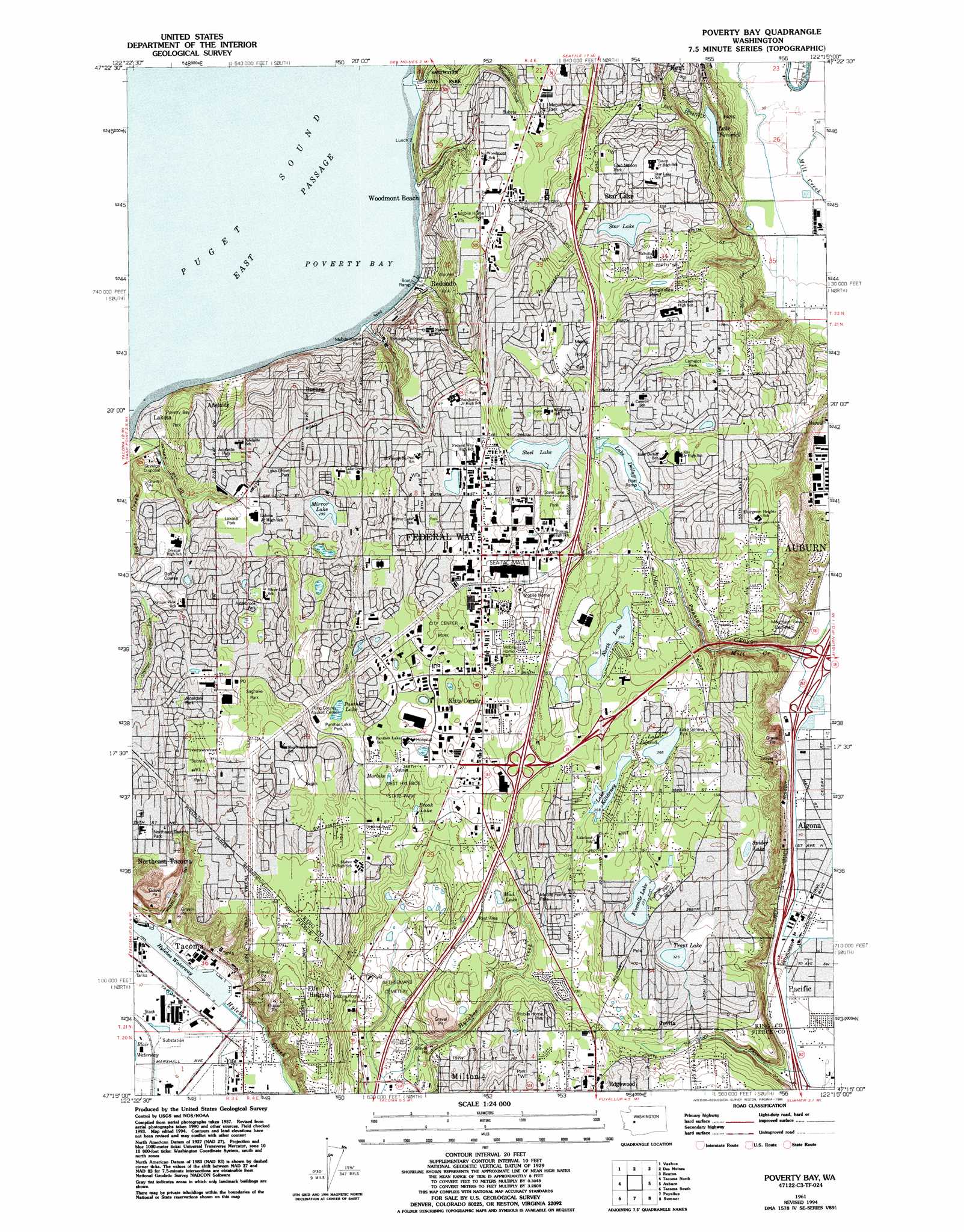
USGS Topo Quad 47122c3 - 1:24,000 scale
| Topo Map Name: | Poverty Bay |
| USGS Topo Quad ID: | 47122c3 |
| Print Size: | ca. 21 1/4" wide x 27" high |
| Southeast Coordinates: | 47.25° N latitude / 122.25° W longitude |
| Map Center Coordinates: | 47.3125° N latitude / 122.3125° W longitude |
| U.S. State: | WA |
| Filename: | o47122c3.jpg |
| Download Map JPG Image: | Poverty Bay topo map 1:24,000 scale |
| Map Type: | Topographic |
| Topo Series: | 7.5´ |
| Map Scale: | 1:24,000 |
| Source of Map Images: | United States Geological Survey (USGS) |
| Alternate Map Versions: |
Poverty Bay WA 1949, updated 1956 Download PDF Buy paper map Poverty Bay WA 1961, updated 1962 Download PDF Buy paper map Poverty Bay WA 1961, updated 1969 Download PDF Buy paper map Poverty Bay WA 1961, updated 1976 Download PDF Buy paper map Poverty Bay WA 1961, updated 1981 Download PDF Buy paper map Poverty Bay WA 1961, updated 1995 Download PDF Buy paper map Poverty Bay WA 1997, updated 2003 Download PDF Buy paper map Poverty Bay WA 2011 Download PDF Buy paper map Poverty Bay WA 2014 Download PDF Buy paper map |
1:24,000 Topo Quads surrounding Poverty Bay
Bremerton East |
Seattle South |
Issaquah |
||
Olalla |
Vashon |
Des Moines |
Renton |
Maple Valley |
Gig Harbor |
Tacoma North |
Poverty Bay |
Auburn |
Black Diamond |
Steilacoom |
Tacoma South |
Puyallup |
Sumner |
Buckley |
Fort Lewis |
Spanaway |
Frederickson |
Orting |
Wilkeson |
> Back to 47122a1 at 1:100,000 scale
> Back to 47122a1 at 1:250,000 scale
> Back to U.S. Topo Maps home
Poverty Bay topo map: Gazetteer
Poverty Bay: Airports
Evergreen Airport (historical) elevation 114m 374′J. J. H. Heliport elevation 133m 436′
Weyerhaeuser Heliport elevation 120m 393′
Poverty Bay: Bays
Poverty Bay elevation 0m 0′Poverty Bay: Crossings
Ellingson Interchange elevation 21m 68′Interchange 142 elevation 105m 344′
Interchange 143 elevation 134m 439′
Interchange 147 elevation 119m 390′
West Auburn Interchange elevation 22m 72′
Poverty Bay: Dams
Weyerhaeuser Dam elevation 114m 374′Poverty Bay: Harbors
Lower Turning Basin elevation -1m -4′Upper Turning Basin elevation 24m 78′
Poverty Bay: Lakes
Bingaman Pond elevation 89m 291′Brook Lake elevation 61m 200′
Fivemile Lake elevation 115m 377′
Lake Dolloff elevation 126m 413′
Lake Fenwick elevation 36m 118′
Lake Geneva elevation 113m 370′
Lake Killarney elevation 113m 370′
Marlake elevation 66m 216′
Mirror Lake elevation 92m 301′
Mud Lake elevation 66m 216′
North Lake elevation 121m 396′
Panther Lake elevation 78m 255′
Spider Lake elevation 121m 396′
Star Lake elevation 102m 334′
Steel Lake elevation 133m 436′
Trout Lake elevation 100m 328′
Poverty Bay: Parks
Lake Fenwick Park elevation 42m 137′Nelson Park elevation 130m 426′
Saltwater State Park elevation 4m 13′
Steel Lake Park elevation 137m 449′
Poverty Bay: Populated Places
Adelaide elevation 74m 242′Algona elevation 24m 78′
Buenna elevation 112m 367′
Edgewood elevation 108m 354′
Federal Way elevation 141m 462′
Fife Heights elevation 124m 406′
Jovita elevation 113m 370′
Kitts Corner elevation 98m 321′
Lakeland elevation 112m 367′
Lakota elevation 12m 39′
Mirror Lake elevation 108m 354′
Northeast Tacoma elevation 124m 406′
Pacific elevation 24m 78′
Redondo elevation 6m 19′
Star Lake elevation 116m 380′
Woodmont Beach elevation 90m 295′
Poverty Bay: Post Offices
Auburn Twin Lake Post Office elevation 102m 334′Poverty Bay: Streams
McSorley Creek elevation 2m 6′West Hylebos Creek elevation 6m 19′
Poverty Bay: Valleys
Peasley Canyon elevation 23m 75′Poverty Bay digital topo map on disk
Buy this Poverty Bay topo map showing relief, roads, GPS coordinates and other geographical features, as a high-resolution digital map file on DVD: