Gig Harbor Topo Map Washington
To zoom in, hover over the map of Gig Harbor
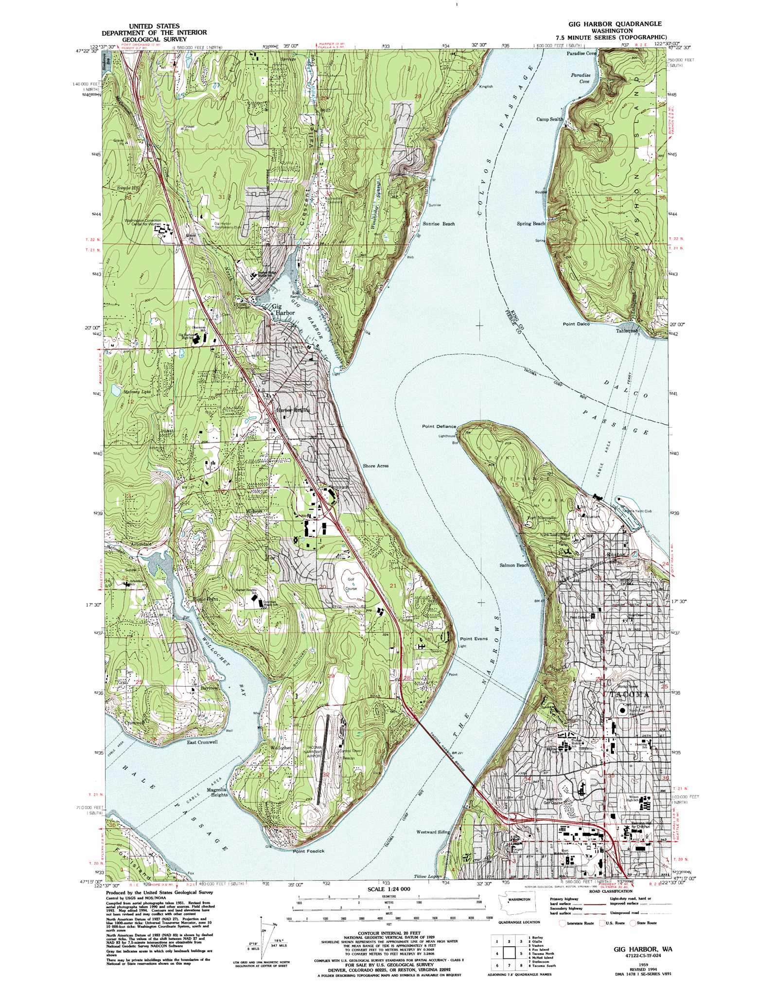
USGS Topo Quad 47122c5 - 1:24,000 scale
| Topo Map Name: | Gig Harbor |
| USGS Topo Quad ID: | 47122c5 |
| Print Size: | ca. 21 1/4" wide x 27" high |
| Southeast Coordinates: | 47.25° N latitude / 122.5° W longitude |
| Map Center Coordinates: | 47.3125° N latitude / 122.5625° W longitude |
| U.S. State: | WA |
| Filename: | o47122c5.jpg |
| Download Map JPG Image: | Gig Harbor topo map 1:24,000 scale |
| Map Type: | Topographic |
| Topo Series: | 7.5´ |
| Map Scale: | 1:24,000 |
| Source of Map Images: | United States Geological Survey (USGS) |
| Alternate Map Versions: |
Gig Harbor WA 1953, updated 1955 Download PDF Buy paper map Gig Harbor WA 1959, updated 1960 Download PDF Buy paper map Gig Harbor WA 1959, updated 1970 Download PDF Buy paper map Gig Harbor WA 1959, updated 1976 Download PDF Buy paper map Gig Harbor WA 1959, updated 1981 Download PDF Buy paper map Gig Harbor WA 1959, updated 1995 Download PDF Buy paper map Gig Harbor WA 1997, updated 2003 Download PDF Buy paper map Gig Harbor WA 2011 Download PDF Buy paper map Gig Harbor WA 2014 Download PDF Buy paper map |
1:24,000 Topo Quads surrounding Gig Harbor
Wildcat Lake |
Bremerton West |
Bremerton East |
Seattle South |
|
Belfair |
Burley |
Olalla |
Vashon |
Des Moines |
Vaughn |
Fox Island |
Gig Harbor |
Tacoma North |
Poverty Bay |
Longbranch |
Mcneil Island |
Steilacoom |
Tacoma South |
Puyallup |
Lacey |
Nisqually |
Fort Lewis |
Spanaway |
Frederickson |
> Back to 47122a1 at 1:100,000 scale
> Back to 47122a1 at 1:250,000 scale
> Back to U.S. Topo Maps home
Gig Harbor topo map: Gazetteer
Gig Harbor: Airports
Gig Harbor Seaplane Base elevation 17m 55′Tacoma Narrows Airport elevation 90m 295′
Telephone Utilities Heliport elevation 89m 291′
Gig Harbor: Bays
Gig Harbor elevation 0m 0′Paradise Cove elevation 1m 3′
Wollochet Bay elevation 1m 3′
Gig Harbor: Bridges
Tacoma Narrows Bridge elevation 2m 6′Gig Harbor: Capes
Point Dalco elevation 24m 78′Point Defiance elevation 22m 72′
Point Evans elevation 1m 3′
Point Fosdick elevation 8m 26′
Gig Harbor: Channels
Dalco Passage elevation 0m 0′The Narrow elevation 1m 3′
The Narrows elevation 1m 3′
Gig Harbor: Crossings
Gig Harbor Interchange elevation 83m 272′Olympic Interchange elevation 94m 308′
Gig Harbor: Dams
North End Reservoir Dam elevation 131m 429′Gig Harbor: Parks
Point Defiance Park elevation 68m 223′Titlow Beach Park elevation 16m 52′
Gig Harbor: Populated Places
Artondale elevation 6m 19′Bayview elevation 41m 134′
Cromwell elevation 22m 72′
East Cromwell elevation 49m 160′
Fort Nisqually elevation 72m 236′
Gig Harbor elevation 9m 29′
Harbor Heights elevation 90m 295′
Magnolia Heights elevation 29m 95′
Midway elevation 82m 269′
Ruston elevation 14m 45′
Shore Acres elevation 51m 167′
Spring Beach elevation 15m 49′
Swede Hill elevation 82m 269′
Tahlequah elevation 6m 19′
Wollochet elevation 59m 193′
Gig Harbor: Post Offices
Camp Sealth Post Office (historical) elevation 8m 26′Gig Harbor: Reservoirs
North End Reservoir elevation 131m 429′Gig Harbor: Streams
Artondale Creek elevation 2m 6′Crescent Creek elevation 9m 29′
North Creek elevation 0m 0′
Tahlequah Creek elevation 9m 29′
Gig Harbor: Summits
Kinbee Hill elevation 98m 321′Gig Harbor: Swamps
Winchester Swamp elevation 103m 337′Gig Harbor: Tunnels
Asarco Smelter Tunnel elevation 30m 98′Nelson Bennett Tunnel elevation 70m 229′
Gig Harbor: Valleys
Crescent Valley elevation 16m 52′Sullivan Gulch elevation 5m 16′
Gig Harbor digital topo map on disk
Buy this Gig Harbor topo map showing relief, roads, GPS coordinates and other geographical features, as a high-resolution digital map file on DVD: