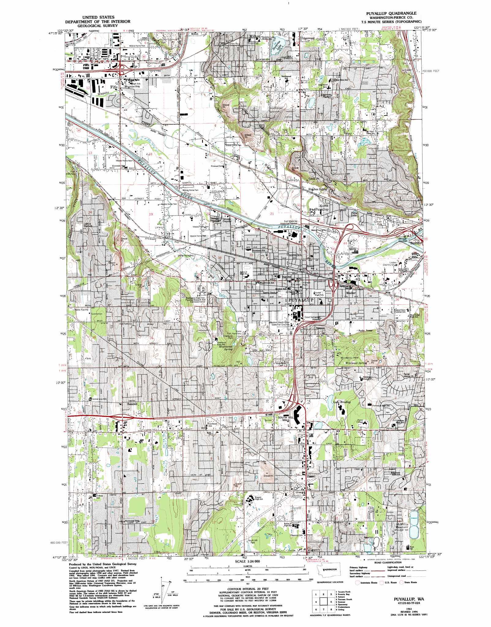
Puyallup Topo Map Washington
To zoom in, hover over the map of Puyallup
USGS Topo Quad 47122b3 - 1:24,000 scale
| Topo Map Name: | Puyallup |
| USGS Topo Quad ID: | 47122b3 |
| Print Size: | ca. 21 1/4" wide x 27" high |
| Southeast Coordinates: | 47.125° N latitude / 122.25° W longitude |
| Map Center Coordinates: | 47.1875° N latitude / 122.3125° W longitude |
| U.S. State: | WA |
| Filename: | o47122b3.jpg |
| Download Map JPG Image: | Puyallup topo map 1:24,000 scale |
| Map Type: | Topographic |
| Topo Series: | 7.5´ |
| Map Scale: | 1:24,000 |
| Source of Map Images: | United States Geological Survey (USGS) |
| Alternate Map Versions: |
Puyallup WA 1961, updated 1962 Download PDF Buy paper map Puyallup WA 1961, updated 1969 Download PDF Buy paper map Puyallup WA 1961, updated 1976 Download PDF Buy paper map Puyallup WA 1961, updated 1981 Download PDF Buy paper map Puyallup WA 1961, updated 1995 Download PDF Buy paper map Puyallup WA 1997, updated 2003 Download PDF Buy paper map Puyallup WA 2011 Download PDF Buy paper map Puyallup WA 2014 Download PDF Buy paper map |
1:24,000 Topo Quads surrounding Puyallup
Olalla |
Vashon |
Des Moines |
Renton |
Maple Valley |
Gig Harbor |
Tacoma North |
Poverty Bay |
Auburn |
Black Diamond |
Steilacoom |
Tacoma South |
Puyallup |
Sumner |
Buckley |
Fort Lewis |
Spanaway |
Frederickson |
Orting |
Wilkeson |
Mckenna |
Harts Lake |
Tanwax Lake |
Lake Kapowsin |
Le Dout Creek |
> Back to 47122a1 at 1:100,000 scale
> Back to 47122a1 at 1:250,000 scale
> Back to U.S. Topo Maps home
Puyallup topo map: Gazetteer
Puyallup: Airports
Good Samaritan Hosp Heliport elevation 42m 137′Puyallup: Crossings
Fife Interchange elevation 6m 19′Interchange 137 elevation 6m 19′
Puyallup: Dams
Bradley Lake Dam elevation 129m 423′Firwood Pit Dam elevation 16m 52′
McMillin North Reservoir Number One Dam elevation 179m 587′
McMillin Reservoir Number Two Dam elevation 179m 587′
McMillin South Reservoir Number One Dam elevation 179m 587′
Puyallup: Lakes
Lake Chalet elevation 109m 357′Pony Lake elevation 16m 52′
Surprise Lake elevation 96m 314′
Puyallup: Parks
Edgewood Community Park elevation 124m 406′Fort Malone Historical Marker elevation 14m 45′
Grayland Park elevation 13m 42′
Pioneer Park elevation 15m 49′
Wildwood Park elevation 108m 354′
Puyallup: Populated Places
Fife elevation 7m 22′Meeker elevation 17m 55′
Milton elevation 93m 305′
North Puyallup elevation 16m 52′
Puyallup elevation 14m 45′
South Hill elevation 163m 534′
Summit elevation 145m 475′
Waller elevation 119m 390′
Puyallup: Post Offices
Milton Post Office elevation 104m 341′Puyallup Post Office elevation 15m 49′
Puyallup: Reservoirs
Firwood Pit elevation 16m 52′Lake Bradley elevation 129m 423′
McMillin Reservoir elevation 179m 587′
McMillin Reservoir Number 1-North elevation 179m 587′
McMillin Reservoir Number 1-South elevation 179m 587′
McMillin Reservoir Number Two elevation 179m 587′
Puyallup: Springs
Maplewood Spring elevation 18m 59′Wildwood Spring elevation 117m 383′
Puyallup: Streams
Clarks Creek elevation 6m 19′Simons Creek elevation 13m 42′
White River elevation 9m 29′
Puyallup: Valleys
Puyallup Valley elevation 69m 226′Puyallup digital topo map on disk
Buy this Puyallup topo map showing relief, roads, GPS coordinates and other geographical features, as a high-resolution digital map file on DVD: