Rayburn Topo Map Texas
To zoom in, hover over the map of Rayburn
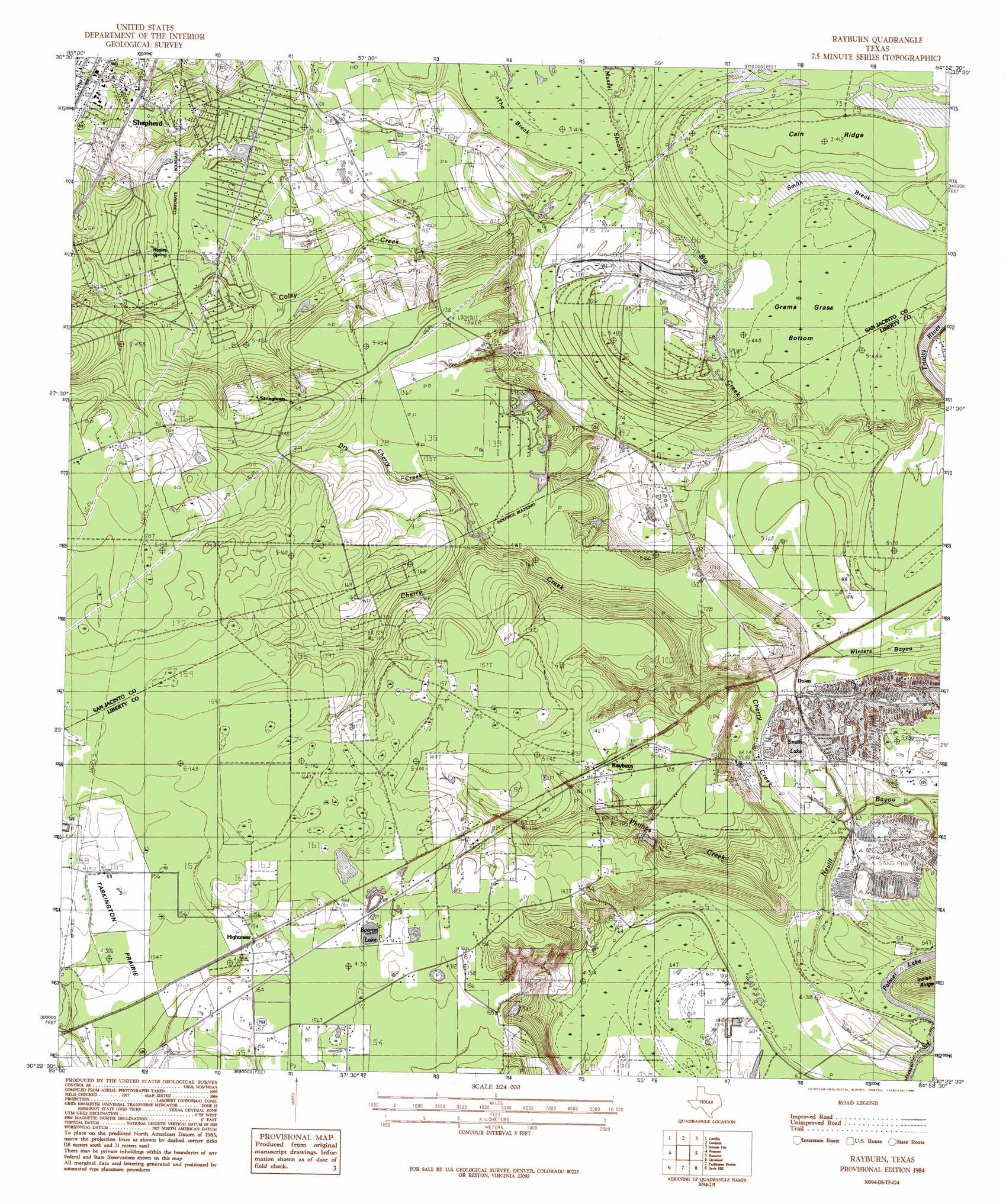
USGS Topo Quad 30094d8 - 1:24,000 scale
| Topo Map Name: | Rayburn |
| USGS Topo Quad ID: | 30094d8 |
| Print Size: | ca. 21 1/4" wide x 27" high |
| Southeast Coordinates: | 30.375° N latitude / 94.875° W longitude |
| Map Center Coordinates: | 30.4375° N latitude / 94.9375° W longitude |
| U.S. State: | TX |
| Filename: | o30094d8.jpg |
| Download Map JPG Image: | Rayburn topo map 1:24,000 scale |
| Map Type: | Topographic |
| Topo Series: | 7.5´ |
| Map Scale: | 1:24,000 |
| Source of Map Images: | United States Geological Survey (USGS) |
| Alternate Map Versions: |
Rayburn TX 1984, updated 1985 Download PDF Buy paper map Rayburn TX 1997, updated 2000 Download PDF Buy paper map Rayburn TX 2010 Download PDF Buy paper map Rayburn TX 2013 Download PDF Buy paper map Rayburn TX 2016 Download PDF Buy paper map |
| FStopo: | US Forest Service topo Rayburn is available: Download FStopo PDF Download FStopo TIF |
1:24,000 Topo Quads surrounding Rayburn
Stephen Creek |
Blanchard |
Livingston |
Soda |
Dallardsville |
Coldspring |
Camilla |
Goodrich |
Schwab City |
Segno |
Bear Creek |
Westcott |
Rayburn |
Romayor |
Votaw |
Fostoria |
Cleveland |
Tarkington Prairie |
Davis Hill |
Arizona Creek |
Splendora |
Plum Grove |
Simmons Bottom |
Capers Ridge |
Hardin |
> Back to 30094a1 at 1:100,000 scale
> Back to 30094a1 at 1:250,000 scale
> Back to U.S. Topo Maps home
Rayburn topo map: Gazetteer
Rayburn: Airports
Lake Water Wheel Airport elevation 23m 75′Rayburn: Bends
Grama Grass Bottom elevation 19m 62′Rayburn: Dams
Lake Run-A-Muck Dam elevation 29m 95′Lake Tejas Dam elevation 40m 131′
Water Wheels Lake Number 1 Dam elevation 20m 65′
Water Wheels Lake Number 2 Dam elevation 20m 65′
Rayburn: Lakes
Boones Lake elevation 48m 157′Palmer Lake elevation 16m 52′
Smith Lake elevation 21m 68′
Rayburn: Populated Places
Cockrans elevation 49m 160′Dolen elevation 25m 82′
Hightower elevation 47m 154′
Lake Tejas elevation 41m 134′
Lake Water Wheel elevation 23m 75′
Rayburn elevation 42m 137′
Shepherd elevation 44m 144′
Strington elevation 51m 167′
Rayburn: Reservoirs
Lake Run-A-Muck elevation 29m 95′Lake Tejas elevation 40m 131′
Water Wheels Lake Number 1 elevation 20m 65′
Water Wheels Lake Number 2 elevation 20m 65′
Rayburn: Ridges
Cain Ridge elevation 24m 78′Rayburn: Springs
Ragley Spring elevation 33m 108′Rayburn: Streams
Big Creek elevation 14m 45′Cherry Creek elevation 17m 55′
Coley Creek elevation 20m 65′
Davison Bayou elevation 21m 68′
Dry Cherry Creek elevation 34m 111′
Mussel Shoals elevation 21m 68′
Phillips Creek elevation 18m 59′
Winters Bayou elevation 19m 62′
Rayburn: Swamps
Bryants Marsh elevation 20m 65′Smith Break elevation 19m 62′
Rayburn digital topo map on disk
Buy this Rayburn topo map showing relief, roads, GPS coordinates and other geographical features, as a high-resolution digital map file on DVD: