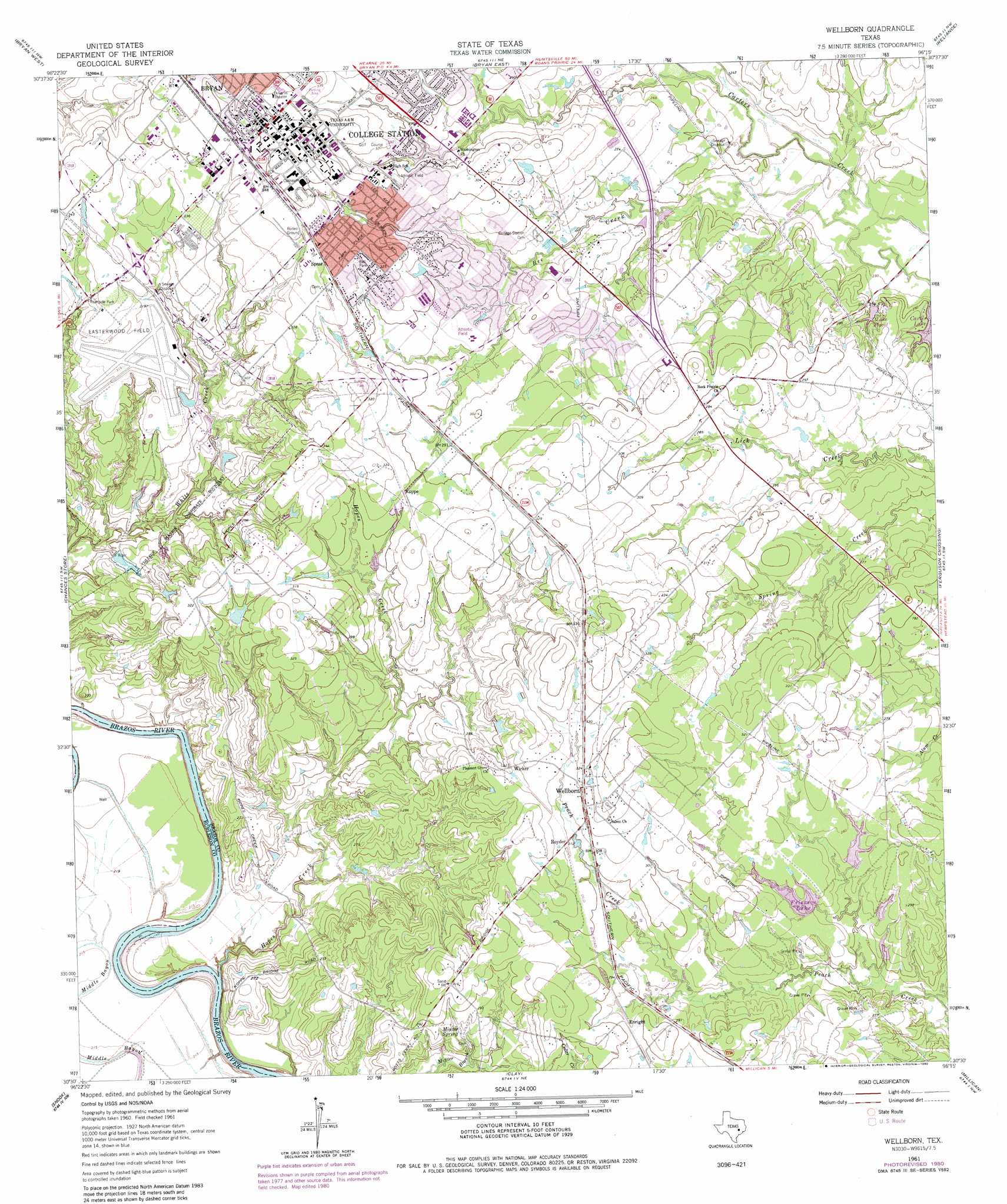
Wellborn Topo Map Texas
To zoom in, hover over the map of Wellborn
USGS Topo Quad 30096e3 - 1:24,000 scale
| Topo Map Name: | Wellborn |
| USGS Topo Quad ID: | 30096e3 |
| Print Size: | ca. 21 1/4" wide x 27" high |
| Southeast Coordinates: | 30.5° N latitude / 96.25° W longitude |
| Map Center Coordinates: | 30.5625° N latitude / 96.3125° W longitude |
| U.S. State: | TX |
| Filename: | o30096e3.jpg |
| Download Map JPG Image: | Wellborn topo map 1:24,000 scale |
| Map Type: | Topographic |
| Topo Series: | 7.5´ |
| Map Scale: | 1:24,000 |
| Source of Map Images: | United States Geological Survey (USGS) |
| Alternate Map Versions: |
Wellborn TX 1961, updated 1965 Download PDF Buy paper map Wellborn TX 1961, updated 1972 Download PDF Buy paper map Wellborn TX 1961, updated 1973 Download PDF Buy paper map Wellborn TX 1961, updated 1980 Download PDF Buy paper map Wellborn TX 2010 Download PDF Buy paper map Wellborn TX 2013 Download PDF Buy paper map Wellborn TX 2016 Download PDF Buy paper map |
1:24,000 Topo Quads surrounding Wellborn
Hearne South |
Dunn Creek |
Kurten |
Clear Lake |
Iola |
Mumford |
Bryan West |
Bryan East |
Reliance |
Keith |
Tunis |
Chances Store |
Wellborn |
Ferguson Crossing |
Carlos |
Lyons |
Snook |
Clay |
Millican |
Navasota |
Somerville |
Gay Hill |
Independence |
Washington |
Courtney |
> Back to 30096e1 at 1:100,000 scale
> Back to 30096a1 at 1:250,000 scale
> Back to U.S. Topo Maps home
Wellborn topo map: Gazetteer
Wellborn: Airports
Easterwood Field elevation 95m 311′Wellborn: Dams
Frierson Lake Number 1 Dam elevation 83m 272′Frierson Lake Number 2 Dam elevation 77m 252′
Frierson Lake Number 3 Dam elevation 82m 269′
Lake Placid Dam elevation 75m 246′
Spearman Lake Dam elevation 80m 262′
Texas A and M University Lake Number 1 Dam elevation 78m 255′
Wellborn: Lakes
Lake Placid elevation 74m 242′Wellborn: Parks
Aggie Soccer Complex elevation 102m 334′Aggie Softball Complex elevation 103m 337′
Anderson Athletic Park elevation 95m 311′
Bee Creek Park elevation 81m 265′
Brison Park elevation 94m 308′
C E 'Pat' Olsen Field elevation 105m 344′
Central Park elevation 83m 272′
G Rollie White Coliseum elevation 107m 351′
Gabbard Park elevation 93m 305′
Kyle Field elevation 107m 351′
Lemon Tree Park elevation 86m 282′
Oaks Park elevation 88m 288′
Raintree Park elevation 78m 255′
Reed Arena elevation 103m 337′
Southwood Park elevation 96m 314′
Thomas Park elevation 94m 308′
Tigerland Stadium elevation 86m 282′
Wellborn: Populated Places
Enright elevation 89m 291′Koppe elevation 94m 308′
Royder elevation 95m 311′
Spear elevation 100m 328′
Wellborn elevation 99m 324′
Wicker elevation 100m 328′
Wellborn: Reservoirs
Frierson Lake Number 1 elevation 83m 272′Frierson Lake Number 2 elevation 77m 252′
Frierson Lake Number 3 elevation 82m 269′
Lake Placid elevation 75m 246′
Spearman Lake elevation 80m 262′
Texas A and M University Lake Number 1 elevation 78m 255′
Wellborn: Springs
Minter Spring elevation 82m 269′Wellborn: Streams
Bee Creek elevation 70m 229′Hopes Creek elevation 54m 177′
Wellborn digital topo map on disk
Buy this Wellborn topo map showing relief, roads, GPS coordinates and other geographical features, as a high-resolution digital map file on DVD: