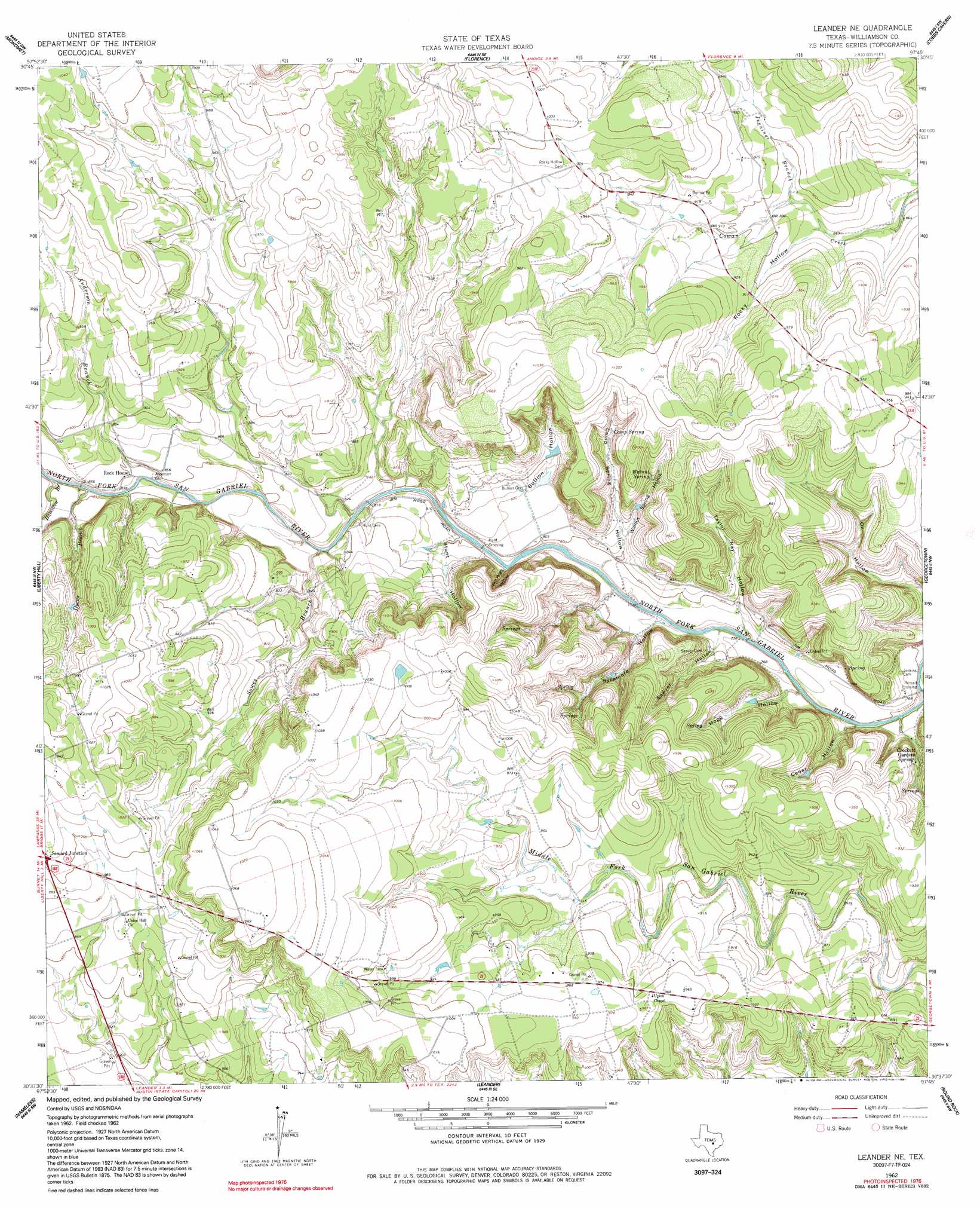
Leander Ne Topo Map Texas
To zoom in, hover over the map of Leander Ne
USGS Topo Quad 30097f7 - 1:24,000 scale
| Topo Map Name: | Leander Ne |
| USGS Topo Quad ID: | 30097f7 |
| Print Size: | ca. 21 1/4" wide x 27" high |
| Southeast Coordinates: | 30.625° N latitude / 97.75° W longitude |
| Map Center Coordinates: | 30.6875° N latitude / 97.8125° W longitude |
| U.S. State: | TX |
| Filename: | o30097f7.jpg |
| Download Map JPG Image: | Leander Ne topo map 1:24,000 scale |
| Map Type: | Topographic |
| Topo Series: | 7.5´ |
| Map Scale: | 1:24,000 |
| Source of Map Images: | United States Geological Survey (USGS) |
| Alternate Map Versions: |
Leander NE TX 1962, updated 1966 Download PDF Buy paper map Leander NE TX 1962, updated 1980 Download PDF Buy paper map Leander NE TX 1962, updated 1980 Download PDF Buy paper map Leander NE TX 1962, updated 1991 Download PDF Buy paper map Leander NE TX 2010 Download PDF Buy paper map Leander NE TX 2013 Download PDF Buy paper map Leander NE TX 2016 Download PDF Buy paper map |
1:24,000 Topo Quads surrounding Leander Ne
Bachelor Peak |
Briggs |
Ding Dong |
Youngsport |
Salado |
Joppa |
Mahomet |
Florence |
Cobbs Cavern |
Jarrell |
Bertram |
Liberty Hill |
Leander Ne |
Georgetown |
Weir |
Travis Peak |
Nameless |
Leander |
Round Rock |
Hutto |
Pace Bend |
Mansfield Dam |
Jollyville |
Pflugerville West |
Pflugerville East |
> Back to 30097e1 at 1:100,000 scale
> Back to 30096a1 at 1:250,000 scale
> Back to U.S. Topo Maps home
Leander Ne topo map: Gazetteer
Leander Ne: Airports
4BH Heliport elevation 287m 941′Hilde-Griff Field elevation 288m 944′
Leander Ne: Areas
Crockett Gardens elevation 253m 830′Leander Ne: Parks
Russell Park elevation 263m 862′Sawyer Park elevation 280m 918′
Walnut Spring Park elevation 276m 905′
Leander Ne: Populated Places
Hunt Crossing elevation 241m 790′Russell Crossing elevation 237m 777′
Leander Ne: Springs
Camp Spring elevation 271m 889′Knight Spring elevation 269m 882′
Walnut Spring elevation 274m 898′
Leander Ne: Streams
Anderson Branch elevation 250m 820′Dyeus Branch elevation 253m 830′
Hamilton Branch elevation 253m 830′
Jennings Branch elevation 264m 866′
Sowes Branch elevation 243m 797′
Leander Ne: Valleys
Bullion Hollow elevation 247m 810′Camp Spring Hollow elevation 246m 807′
Cedar Hollow elevation 230m 754′
Hunt Hollow elevation 243m 797′
Jim Hogg Hollow elevation 239m 784′
Rocky Hollow elevation 267m 875′
Sawyer Hollow elevation 235m 770′
Spring Hogg Hollow elevation 232m 761′
Sycamore Hollow elevation 236m 774′
Taylor Ray Hollow elevation 235m 770′
Walnut Spring Hollow elevation 246m 807′
Leander Ne digital topo map on disk
Buy this Leander Ne topo map showing relief, roads, GPS coordinates and other geographical features, as a high-resolution digital map file on DVD: