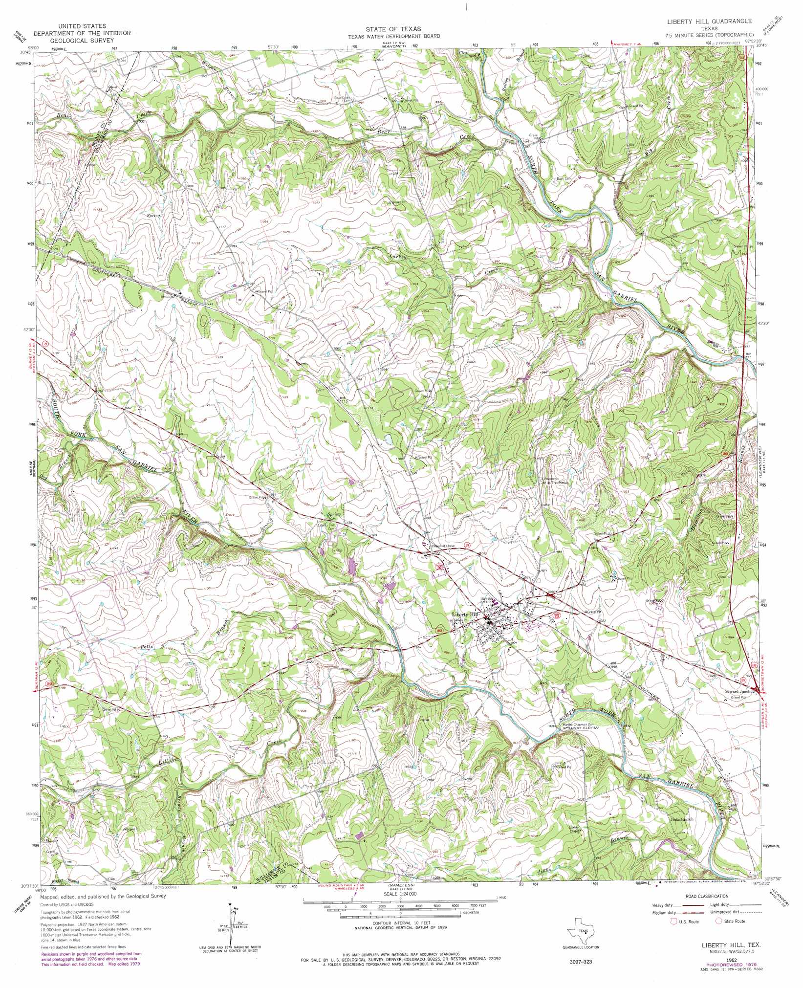
Liberty Hill Topo Map Texas
To zoom in, hover over the map of Liberty Hill
USGS Topo Quad 30097f8 - 1:24,000 scale
| Topo Map Name: | Liberty Hill |
| USGS Topo Quad ID: | 30097f8 |
| Print Size: | ca. 21 1/4" wide x 27" high |
| Southeast Coordinates: | 30.625° N latitude / 97.875° W longitude |
| Map Center Coordinates: | 30.6875° N latitude / 97.9375° W longitude |
| U.S. State: | TX |
| Filename: | o30097f8.jpg |
| Download Map JPG Image: | Liberty Hill topo map 1:24,000 scale |
| Map Type: | Topographic |
| Topo Series: | 7.5´ |
| Map Scale: | 1:24,000 |
| Source of Map Images: | United States Geological Survey (USGS) |
| Alternate Map Versions: |
Liberty Hill TX 1962, updated 1966 Download PDF Buy paper map Liberty Hill TX 1962, updated 1979 Download PDF Buy paper map Liberty Hill TX 2010 Download PDF Buy paper map Liberty Hill TX 2013 Download PDF Buy paper map Liberty Hill TX 2016 Download PDF Buy paper map |
1:24,000 Topo Quads surrounding Liberty Hill
Lake Victor |
Bachelor Peak |
Briggs |
Ding Dong |
Youngsport |
Burnet |
Joppa |
Mahomet |
Florence |
Cobbs Cavern |
Mormon Mill |
Bertram |
Liberty Hill |
Leander Ne |
Georgetown |
Smithwick |
Travis Peak |
Nameless |
Leander |
Round Rock |
Spicewood |
Pace Bend |
Mansfield Dam |
Jollyville |
Pflugerville West |
> Back to 30097e1 at 1:100,000 scale
> Back to 30096a1 at 1:250,000 scale
> Back to U.S. Topo Maps home
Liberty Hill topo map: Gazetteer
Liberty Hill: Dams
Martha Chapman Dam elevation 281m 921′San Gabriel River Ranch Lake Dam elevation 272m 892′
Liberty Hill: Populated Places
Jinks Branch elevation 296m 971′Liberty Hill elevation 312m 1023′
Seward Junction elevation 309m 1013′
Liberty Hill: Reservoirs
San Gabriel River Ranch Lake elevation 272m 892′Liberty Hill: Streams
Bear Creek elevation 269m 882′Big Branch elevation 298m 977′
Brewer Branch elevation 316m 1036′
Bullion Branch elevation 276m 905′
Clear Creek elevation 278m 912′
Dog Branch elevation 310m 1017′
Jenkins Branch elevation 296m 971′
Jinks Branch elevation 287m 941′
Lackey Creek elevation 265m 869′
Little Creek elevation 290m 951′
Potts Branch elevation 293m 961′
Wilson Branch elevation 299m 980′
Liberty Hill digital topo map on disk
Buy this Liberty Hill topo map showing relief, roads, GPS coordinates and other geographical features, as a high-resolution digital map file on DVD: