Georgetown Topo Map Texas
To zoom in, hover over the map of Georgetown
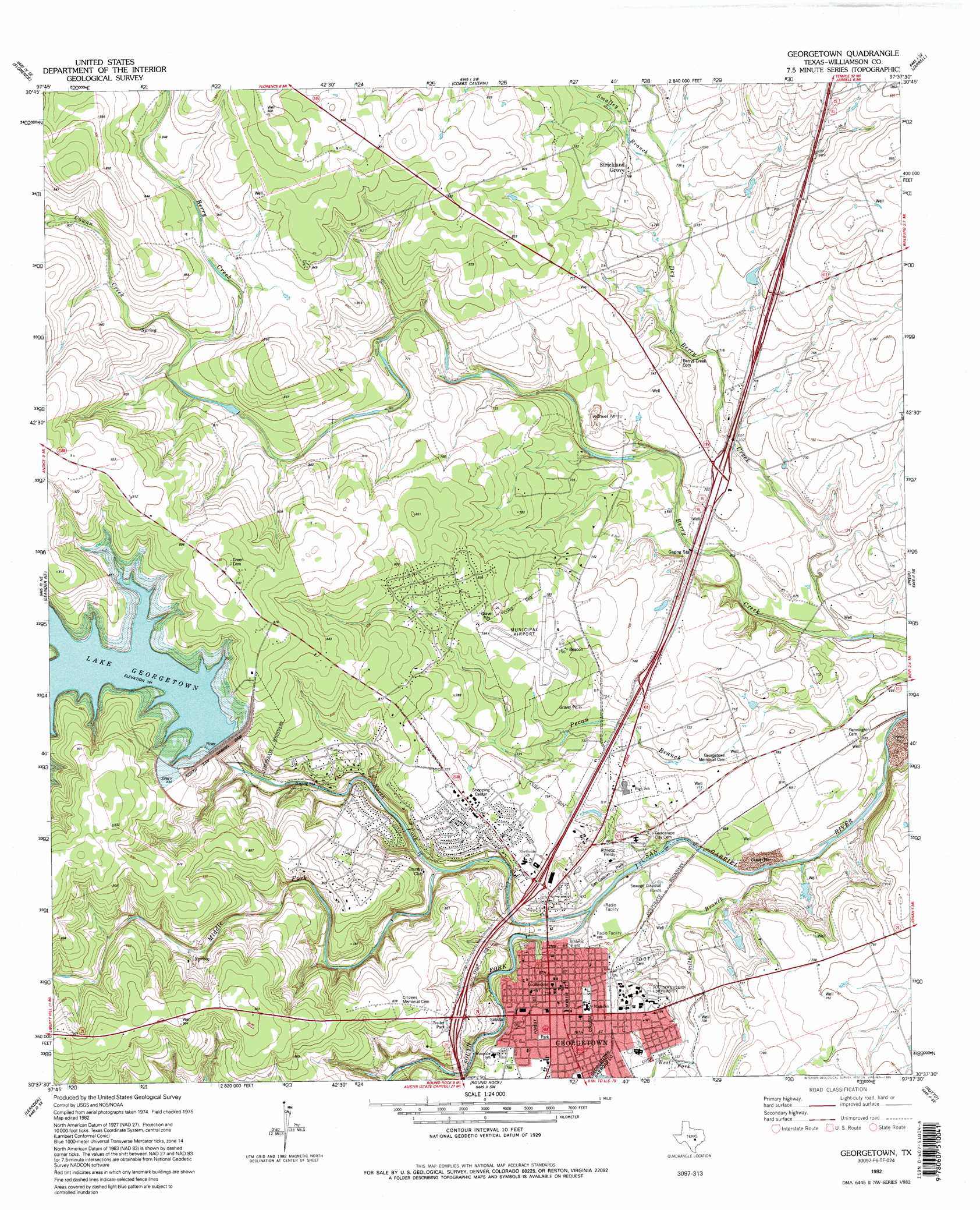
USGS Topo Quad 30097f6 - 1:24,000 scale
| Topo Map Name: | Georgetown |
| USGS Topo Quad ID: | 30097f6 |
| Print Size: | ca. 21 1/4" wide x 27" high |
| Southeast Coordinates: | 30.625° N latitude / 97.625° W longitude |
| Map Center Coordinates: | 30.6875° N latitude / 97.6875° W longitude |
| U.S. State: | TX |
| Filename: | o30097f6.jpg |
| Download Map JPG Image: | Georgetown topo map 1:24,000 scale |
| Map Type: | Topographic |
| Topo Series: | 7.5´ |
| Map Scale: | 1:24,000 |
| Source of Map Images: | United States Geological Survey (USGS) |
| Alternate Map Versions: |
Georgetown TX 1982, updated 1986 Download PDF Buy paper map Georgetown TX 1982, updated 1987 Download PDF Buy paper map Georgetown TX 1982, updated 1995 Download PDF Buy paper map Georgetown TX 2010 Download PDF Buy paper map Georgetown TX 2013 Download PDF Buy paper map Georgetown TX 2016 Download PDF Buy paper map |
1:24,000 Topo Quads surrounding Georgetown
Briggs |
Ding Dong |
Youngsport |
Salado |
Holland |
Mahomet |
Florence |
Cobbs Cavern |
Jarrell |
Bartlett |
Liberty Hill |
Leander Ne |
Georgetown |
Weir |
Granger |
Nameless |
Leander |
Round Rock |
Hutto |
Taylor |
Mansfield Dam |
Jollyville |
Pflugerville West |
Pflugerville East |
Coupland |
> Back to 30097e1 at 1:100,000 scale
> Back to 30096a1 at 1:250,000 scale
> Back to U.S. Topo Maps home
Georgetown topo map: Gazetteer
Georgetown: Airports
Georgetown Municipal Airport elevation 234m 767′Landry Stolport elevation 216m 708′
Georgetown: Dams
North Sam Gabriel Dam elevation 230m 754′North San Gabriel Dam elevation 249m 816′
Georgetown: Parks
B E Birkelbach Stadium elevation 210m 688′Cedar Breaks Park elevation 270m 885′
Eagle Field- Georgetown elevation 221m 725′
Jim Hogg Park elevation 262m 859′
McMasters Athletics Complex elevation 208m 682′
Mickler Park elevation 221m 725′
San Gabriel Park elevation 208m 682′
Veterans of Foreign Wars Park elevation 211m 692′
Georgetown: Populated Places
Berrys Creek elevation 227m 744′Georgetown elevation 230m 754′
North Georgetown elevation 216m 708′
Serenada elevation 250m 820′
Sun City elevation 266m 872′
Georgetown: Reservoirs
Lake Georgetown elevation 230m 754′North Fork Lake elevation 249m 816′
Georgetown: Springs
Berry Springs elevation 203m 666′Georgetown Springs elevation 234m 767′
Georgetown: Streams
Cowan Creek elevation 241m 790′Dry Berry Creek elevation 197m 646′
Middle Fork San Gabriel River elevation 209m 685′
North Fork San Gabriel River elevation 208m 682′
Smalley Branch elevation 223m 731′
Smith Branch elevation 205m 672′
South Fork San Gabriel River elevation 208m 682′
West Fork Smith Branch elevation 220m 721′
Georgetown: Trails
Falls of San Gabriel Trail elevation 230m 754′Good Water Trail elevation 257m 843′
Pickett Trail elevation 205m 672′
Georgetown: Valleys
Ox Hollow elevation 241m 790′Georgetown digital topo map on disk
Buy this Georgetown topo map showing relief, roads, GPS coordinates and other geographical features, as a high-resolution digital map file on DVD: