Dothan West Topo Map Alabama
To zoom in, hover over the map of Dothan West
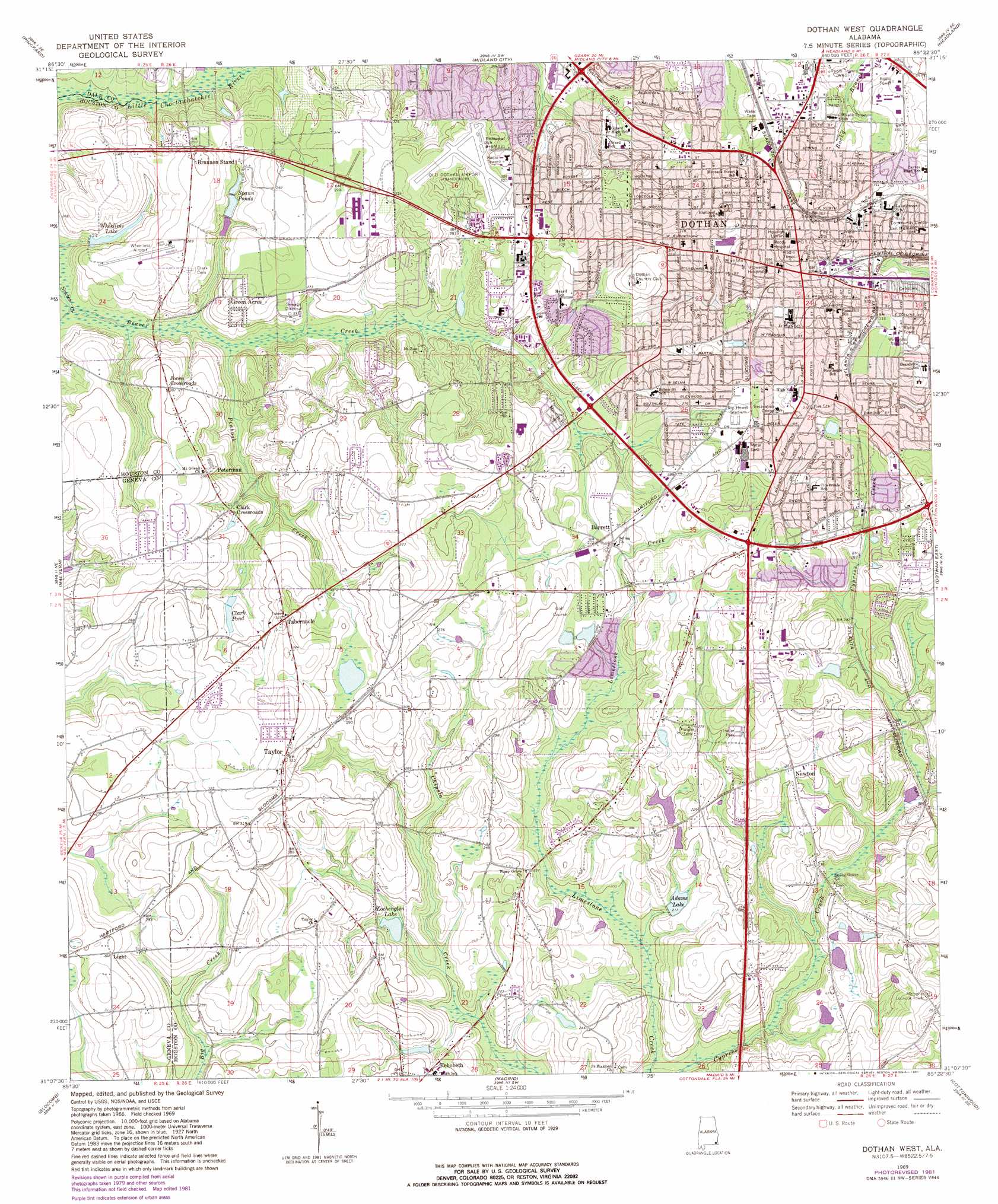
USGS Topo Quad 31085b4 - 1:24,000 scale
| Topo Map Name: | Dothan West |
| USGS Topo Quad ID: | 31085b4 |
| Print Size: | ca. 21 1/4" wide x 27" high |
| Southeast Coordinates: | 31.125° N latitude / 85.375° W longitude |
| Map Center Coordinates: | 31.1875° N latitude / 85.4375° W longitude |
| U.S. State: | AL |
| Filename: | o31085b4.jpg |
| Download Map JPG Image: | Dothan West topo map 1:24,000 scale |
| Map Type: | Topographic |
| Topo Series: | 7.5´ |
| Map Scale: | 1:24,000 |
| Source of Map Images: | United States Geological Survey (USGS) |
| Alternate Map Versions: |
Dothan West AL 1969, updated 1971 Download PDF Buy paper map Dothan West AL 1969, updated 1981 Download PDF Buy paper map Dothan West AL 2011 Download PDF Buy paper map Dothan West AL 2014 Download PDF Buy paper map |
1:24,000 Topo Quads surrounding Dothan West
Ozark |
Ewell |
Echo |
Newville |
Haleburg |
Daleville |
Pinckard |
Midland City |
Headland |
Sigma |
Clayhatchee |
Malvern |
Dothan West |
Dothan East |
Ashford |
Hartford |
Slocomb |
Madrid |
Cottonwood |
Grangeburg |
Esto |
Graceville |
Campbellton |
Sills |
Malone |
> Back to 31085a1 at 1:100,000 scale
> Back to 31084a1 at 1:250,000 scale
> Back to U.S. Topo Maps home
Dothan West topo map: Gazetteer
Dothan West: Airports
Wheelless Airport elevation 83m 272′Dothan West: Dams
Adams Lake Dam elevation 66m 216′Dan Morris Lake Dam elevation 75m 246′
Ralph Martin Dam elevation 65m 213′
Wheeless Lake Dam elevation 82m 269′
Dothan West: Lakes
Lochenglen Lake elevation 69m 226′Morris Lake elevation 80m 262′
Dothan West: Parks
Fairlane Park elevation 92m 301′Fairview Park elevation 96m 314′
Pitman Field elevation 99m 324′
Rip Hewes Stadium elevation 87m 285′
Solomon Park elevation 85m 278′
Westgate Memorial Park elevation 91m 298′
Wilson Street Park elevation 88m 288′
Wiregrass Memorial Park elevation 96m 314′
Wiregrass Stadium elevation 96m 314′
Dothan West: Populated Places
Barrett elevation 83m 272′Bel Air elevation 98m 321′
Bell-Merrill elevation 89m 291′
Brannon Stand elevation 90m 295′
Brannon Stand Heights elevation 84m 275′
Brown Estates elevation 97m 318′
Chateau Estates elevation 86m 282′
Cherokee Acres elevation 92m 301′
Chickasaw Heights elevation 88m 288′
Clark Crossroads elevation 82m 269′
Cottondale elevation 96m 314′
Dothan elevation 98m 321′
Fairlane elevation 95m 311′
Glenwood elevation 91m 298′
Green Acres elevation 87m 285′
Harwood Heights elevation 92m 301′
Jones Crossroads elevation 92m 301′
Lakewood Estates elevation 83m 272′
Lamont Court elevation 94m 308′
Melody Heights elevation 89m 291′
Memphis elevation 82m 269′
Miriam Heights elevation 104m 341′
Morris Heights elevation 103m 337′
Mullins elevation 100m 328′
Newton elevation 79m 259′
Normandale elevation 90m 295′
Parish elevation 93m 305′
Parker Village elevation 101m 331′
Peterman elevation 94m 308′
Pine Ridge Estates elevation 88m 288′
Roland elevation 72m 236′
Ross Heights elevation 85m 278′
Shady Heights elevation 93m 305′
Sherwood Forest elevation 101m 331′
Silver Meadows elevation 95m 311′
Solomon Heights elevation 90m 295′
Spann Brothers Estates elevation 88m 288′
Spring Valley Acres elevation 81m 265′
Springdale elevation 87m 285′
Stadium Place elevation 94m 308′
Stonebridge Estates elevation 91m 298′
Sullivan Heights elevation 96m 314′
Tabernacle elevation 98m 321′
Taylor elevation 101m 331′
The Meadows elevation 93m 305′
Tidwell elevation 96m 314′
Trawick Road Estates elevation 86m 282′
Vann elevation 100m 328′
Ward Acres elevation 73m 239′
Whispering Pines elevation 89m 291′
Wiregrass Hills elevation 89m 291′
Dothan West: Post Offices
Dothan Post Office elevation 111m 364′Dothan West: Reservoirs
Adams Lake elevation 68m 223′Clark Pond elevation 87m 285′
Coleman Pond elevation 96m 314′
Cooks Pond elevation 82m 269′
Lakewood Lake elevation 78m 255′
Middleton Lake elevation 75m 246′
Spann Ponds elevation 75m 246′
Wheelless Lake elevation 71m 232′
Dothan West: Streams
Beaver Creek elevation 64m 209′Pinhook Creek elevation 67m 219′
Dothan West digital topo map on disk
Buy this Dothan West topo map showing relief, roads, GPS coordinates and other geographical features, as a high-resolution digital map file on DVD:
Gulf Coast (LA, MS, AL, FL) & Southwestern Georgia
Buy digital topo maps: Gulf Coast (LA, MS, AL, FL) & Southwestern Georgia
 & Southwestern Georgia map DVD")