Extension Topo Map Louisiana
To zoom in, hover over the map of Extension
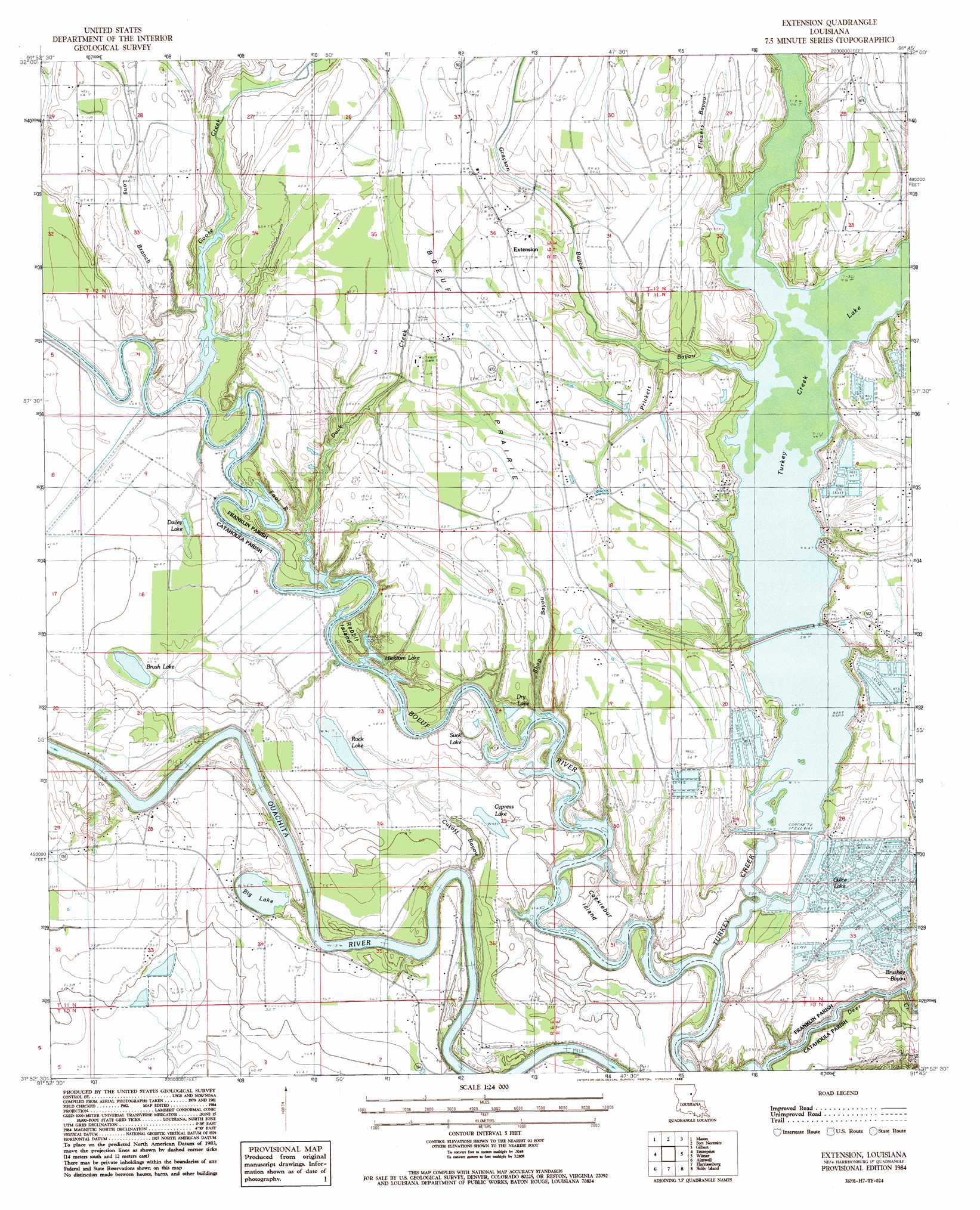
USGS Topo Quad 31091h7 - 1:24,000 scale
| Topo Map Name: | Extension |
| USGS Topo Quad ID: | 31091h7 |
| Print Size: | ca. 21 1/4" wide x 27" high |
| Southeast Coordinates: | 31.875° N latitude / 91.75° W longitude |
| Map Center Coordinates: | 31.9375° N latitude / 91.8125° W longitude |
| U.S. State: | LA |
| Filename: | o31091h7.jpg |
| Download Map JPG Image: | Extension topo map 1:24,000 scale |
| Map Type: | Topographic |
| Topo Series: | 7.5´ |
| Map Scale: | 1:24,000 |
| Source of Map Images: | United States Geological Survey (USGS) |
| Alternate Map Versions: |
Extension LA 1984, updated 1985 Download PDF Buy paper map Extension LA 2012 Download PDF Buy paper map Extension LA 2015 Download PDF Buy paper map |
1:24,000 Topo Quads surrounding Extension
Riverton |
Hebert |
Liddieville |
Winnsboro |
Crowville |
Columbia |
Mason |
Fort Necessity |
Gilbert |
Como |
Holum |
Enterprise |
Extension |
Wisner |
Oakley |
Nickel |
Aimwell |
Harrisonburg |
Sicily Island |
Foules |
Jena East |
Manifest |
Jonesville North |
Dunbarton |
Ferriday North |
> Back to 31091e1 at 1:100,000 scale
> Back to 31090a1 at 1:250,000 scale
> Back to U.S. Topo Maps home
Extension topo map: Gazetteer
Extension: Airports
Turkey Creek Lake Airport elevation 19m 62′Extension: Dams
Turkey Creek Dam elevation 13m 42′Extension: Flats
Boeuf Prairie elevation 19m 62′Extension: Guts
Grayson Bayou elevation 14m 45′Prickett Bayou elevation 14m 45′
Shop Bayou elevation 16m 52′
Extension: Islands
Cocklebur Island elevation 16m 52′Rabbit Island elevation 13m 42′
Extension: Lakes
Barnett Lake elevation 14m 45′Big Lake elevation 14m 45′
Brush Lake elevation 13m 42′
Cypress Lake elevation 13m 42′
Dailey Lake elevation 12m 39′
Dry Lake elevation 11m 36′
Guice Lake elevation 18m 59′
Hicktom Lake elevation 10m 32′
Open Lake elevation 11m 36′
Rock Lake elevation 12m 39′
Sunk Lake elevation 12m 39′
Extension: Populated Places
Extension elevation 19m 62′Jones Landing elevation 12m 39′
Extension: Reservoirs
Big Brake elevation 13m 42′Turkey Creek Lake elevation 15m 49′
Extension: Streams
Brushey Bayou elevation 10m 32′Cutoff Bayou elevation 16m 52′
Duck Creek elevation 12m 39′
Flowers Bayou elevation 13m 42′
Fool River elevation 12m 39′
Goose Creek elevation 12m 39′
Long Branch elevation 12m 39′
Turkey Creek elevation 10m 32′
West Turkey Creek elevation 13m 42′
Extension digital topo map on disk
Buy this Extension topo map showing relief, roads, GPS coordinates and other geographical features, as a high-resolution digital map file on DVD: