Brooks Topo Map Georgia
To zoom in, hover over the map of Brooks
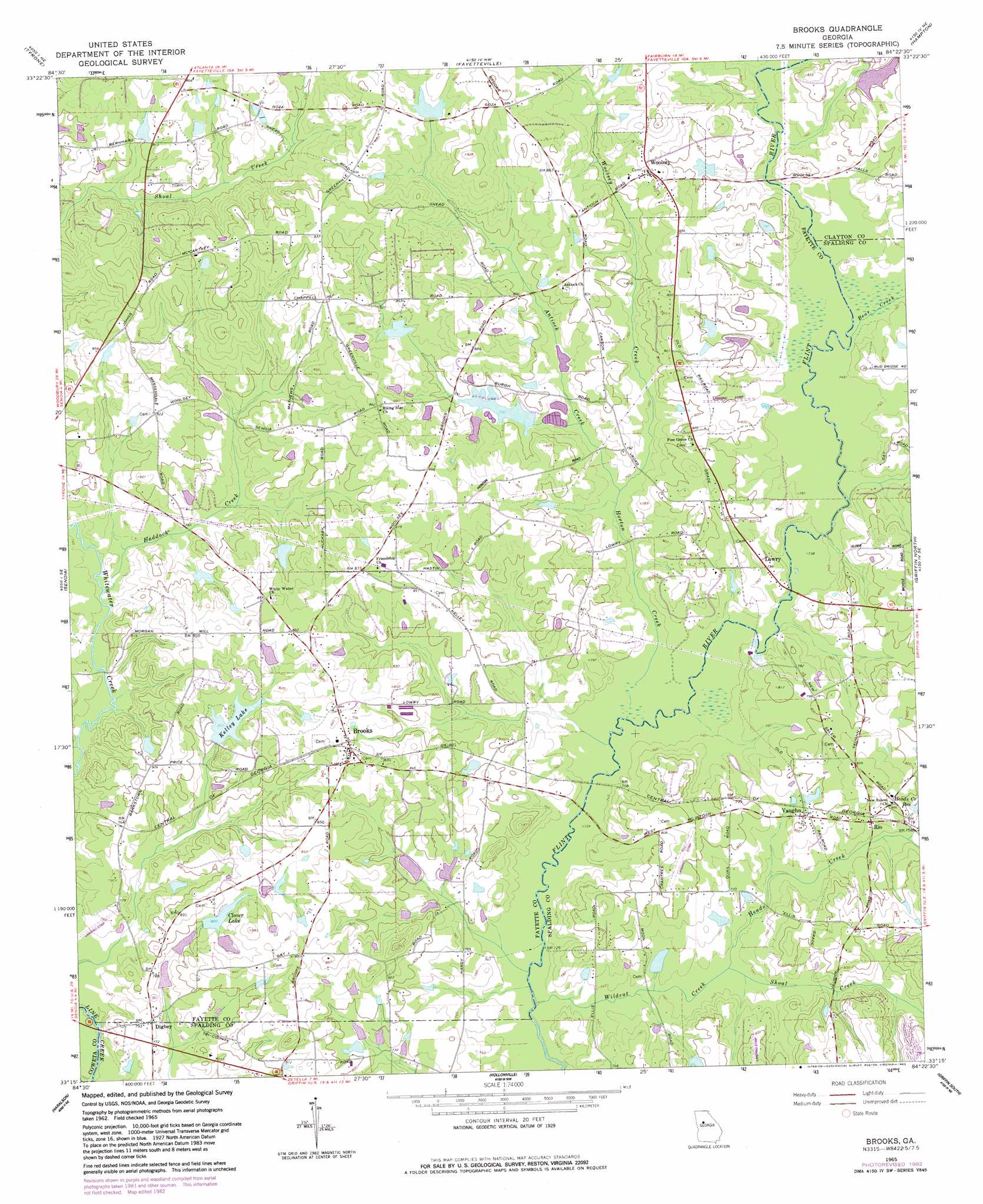
USGS Topo Quad 33084c4 - 1:24,000 scale
| Topo Map Name: | Brooks |
| USGS Topo Quad ID: | 33084c4 |
| Print Size: | ca. 21 1/4" wide x 27" high |
| Southeast Coordinates: | 33.25° N latitude / 84.375° W longitude |
| Map Center Coordinates: | 33.3125° N latitude / 84.4375° W longitude |
| U.S. State: | GA |
| Filename: | o33084c4.jpg |
| Download Map JPG Image: | Brooks topo map 1:24,000 scale |
| Map Type: | Topographic |
| Topo Series: | 7.5´ |
| Map Scale: | 1:24,000 |
| Source of Map Images: | United States Geological Survey (USGS) |
| Alternate Map Versions: |
Brooks GA 1965, updated 1967 Download PDF Buy paper map Brooks GA 1965, updated 1983 Download PDF Buy paper map Brooks GA 2011 Download PDF Buy paper map Brooks GA 2014 Download PDF Buy paper map |
1:24,000 Topo Quads surrounding Brooks
Palmetto |
Fairburn |
Riverdale |
Jonesboro |
Stockbridge |
Madras |
Tyrone |
Fayetteville |
Hampton |
Mcdonough |
Sharpsburg |
Senoia |
Brooks |
Griffin North |
Luella |
Luthersville |
Haralson |
Hollonville |
Griffin South |
Orchard Hill |
Greenville |
Gay |
Concord |
Zebulon |
Barnesville |
> Back to 33084a1 at 1:100,000 scale
> Back to 33084a1 at 1:250,000 scale
> Back to U.S. Topo Maps home
Brooks topo map: Gazetteer
Brooks: Airports
Abernathy Field elevation 227m 744′Brook Bridge Aerodrome elevation 250m 820′
Cedar Ridge Airport elevation 241m 790′
Rust Airstrip elevation 244m 800′
Brooks: Bridges
Bagwell Bridge (historical) elevation 221m 725′Cut Bank Bridge elevation 231m 757′
Dorset Bridge (historical) elevation 224m 734′
Mud Bridge (historical) elevation 230m 754′
Reaves Bridge elevation 225m 738′
Brooks: Dams
Clover Lake Dam elevation 244m 800′Dungan Lake Dam elevation 241m 790′
Goza Dam elevation 274m 898′
Graves Lake Dam elevation 238m 780′
Hogg Dam elevation 237m 777′
Jebco Peoperties Lake Dam elevation 237m 777′
Kelley Lake Dam elevation 243m 797′
Mallory Lake Dam elevation 228m 748′
Oakley Dam elevation 241m 790′
Padgett Lake Dam elevation 247m 810′
Scarbrough Lake Dam elevation 238m 780′
Wyyatt-Grey Lake Dam elevation 243m 797′
Brooks: Populated Places
Bakersfield Farms elevation 243m 797′Bear Creek Landing elevation 248m 813′
Brooks elevation 256m 839′
Broom Hall elevation 258m 846′
Cambridge Estates elevation 238m 780′
Digbey elevation 240m 787′
Friendship elevation 258m 846′
Gantt Acres elevation 263m 862′
Gypsy Woods elevation 248m 813′
Jones Hill Estates elevation 249m 816′
Lowry elevation 231m 757′
Porters Ridge elevation 277m 908′
Rio elevation 241m 790′
Stubbs Plantation elevation 274m 898′
The Meadows elevation 255m 836′
Valdo (historical) elevation 237m 777′
Vaughn elevation 241m 790′
Woolsey elevation 255m 836′
Woolsey Creek Plantation elevation 249m 816′
Woolsey Woods elevation 251m 823′
Brooks: Post Offices
Brooks Post Office elevation 256m 839′Brooks: Reservoirs
Bass Lake elevation 243m 797′Burch Lake elevation 238m 780′
Clover Lake elevation 244m 800′
Dungan Lake elevation 241m 790′
Goza Lake elevation 274m 898′
Graves Lake elevation 238m 780′
Hogg Lake elevation 237m 777′
Jebco Properties Lake elevation 237m 777′
Kelley Lake elevation 243m 797′
Kelley Lake elevation 244m 800′
Mallory Lake elevation 228m 748′
Oakley Lake elevation 241m 790′
Padgett Lake elevation 247m 810′
Scarbrough Lake elevation 238m 780′
Brooks: Streams
Antioch Creek elevation 227m 744′Bear Creek elevation 231m 757′
Haddock Creek elevation 225m 738′
Heads Creek elevation 223m 731′
Horton Creek elevation 223m 731′
Shoal Creek elevation 223m 731′
Wildcat Creek elevation 219m 718′
Woolsey Creek elevation 227m 744′
Brooks: Summits
Jones Hill elevation 283m 928′Brooks digital topo map on disk
Buy this Brooks topo map showing relief, roads, GPS coordinates and other geographical features, as a high-resolution digital map file on DVD: