Hampton Topo Map Georgia
To zoom in, hover over the map of Hampton
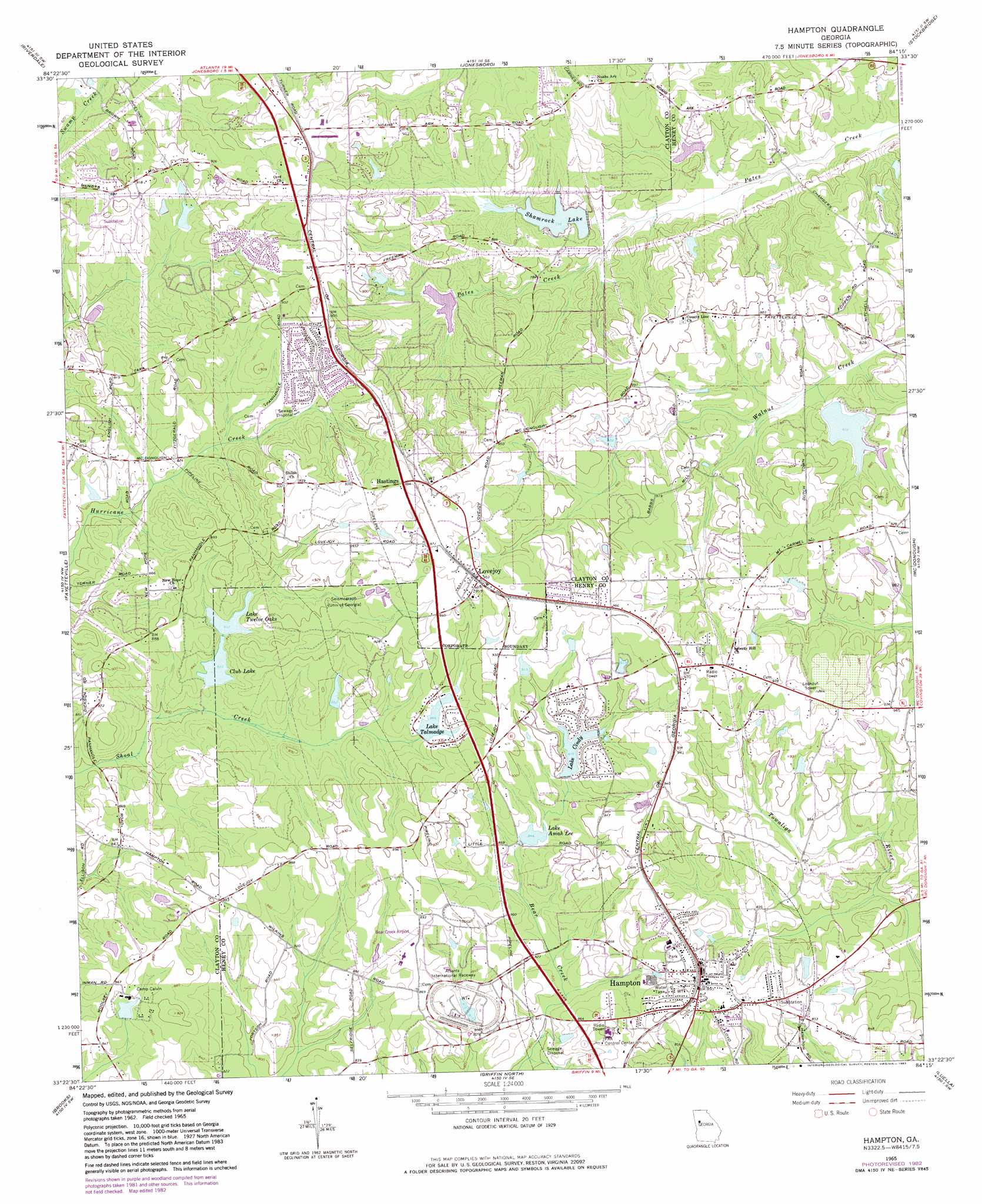
USGS Topo Quad 33084d3 - 1:24,000 scale
| Topo Map Name: | Hampton |
| USGS Topo Quad ID: | 33084d3 |
| Print Size: | ca. 21 1/4" wide x 27" high |
| Southeast Coordinates: | 33.375° N latitude / 84.25° W longitude |
| Map Center Coordinates: | 33.4375° N latitude / 84.3125° W longitude |
| U.S. State: | GA |
| Filename: | o33084d3.jpg |
| Download Map JPG Image: | Hampton topo map 1:24,000 scale |
| Map Type: | Topographic |
| Topo Series: | 7.5´ |
| Map Scale: | 1:24,000 |
| Source of Map Images: | United States Geological Survey (USGS) |
| Alternate Map Versions: |
Hampton GA 1965, updated 1967 Download PDF Buy paper map Hampton GA 1965, updated 1983 Download PDF Buy paper map Hampton GA 1999, updated 2002 Download PDF Buy paper map Hampton GA 2011 Download PDF Buy paper map Hampton GA 2014 Download PDF Buy paper map |
1:24,000 Topo Quads surrounding Hampton
Ben Hill |
Southwest Atlanta |
Southeast Atlanta |
Redan |
Conyers |
Fairburn |
Riverdale |
Jonesboro |
Stockbridge |
Kelleytown |
Tyrone |
Fayetteville |
Hampton |
Mcdonough |
Ola |
Senoia |
Brooks |
Griffin North |
Luella |
Locust Grove |
Haralson |
Hollonville |
Griffin South |
Orchard Hill |
High Falls |
> Back to 33084a1 at 1:100,000 scale
> Back to 33084a1 at 1:250,000 scale
> Back to U.S. Topo Maps home
Hampton topo map: Gazetteer
Hampton: Airports
Bear Creek Airport elevation 262m 859′Deerfield Landing Airport elevation 264m 866′
Henry County Airport-Morris Field elevation 263m 862′
White River Farm Airport elevation 269m 882′
Hampton: Dams
Beaver Dam elevation 259m 849′Camp Calvin Dam elevation 259m 849′
Camp Orr Dam elevation 246m 807′
Cindy Lake Dam elevation 267m 875′
Club Dam elevation 250m 820′
County Line Lake Dam elevation 246m 807′
Feagins Dam elevation 277m 908′
Harbin Dam elevation 235m 770′
Hermans Lake Dam elevation 255m 836′
Lake Amah Lee Dam elevation 257m 843′
Lake Erma Dam elevation 261m 856′
Lake Shamrock Dam elevation 237m 777′
Lake Talmadge Dam elevation 264m 866′
Sams Lake Dam elevation 250m 820′
Schinder Dam elevation 260m 853′
Sinback Dam elevation 250m 820′
Twelve Oaks Lake Dam elevation 254m 833′
Hampton: Parks
Hampton City Park elevation 264m 866′Panhandle Park elevation 258m 846′
Hampton: Populated Places
Bonanza elevation 268m 879′Clover Ranch Mobile Home Park elevation 263m 862′
Crystal Springs elevation 282m 925′
Fortson elevation 265m 869′
Hampton elevation 268m 879′
Hastings elevation 292m 958′
Hidden Hollow elevation 263m 862′
Iron Gate elevation 263m 862′
Irondale elevation 256m 839′
Lake Chase elevation 268m 879′
Lake Cindy Estates elevation 282m 925′
Lake Talmadge elevation 265m 869′
Lovejoy elevation 291m 954′
Mount Carmel Estates elevation 287m 941′
Orrs elevation 287m 941′
The Springs elevation 279m 915′
Walnut Creek elevation 264m 866′
West Hampton elevation 263m 862′
Willow Bend elevation 265m 869′
Woodlawn elevation 262m 859′
Hampton: Post Offices
Hampton Post Office elevation 270m 885′Lovejoy Post Office elevation 287m 941′
Hampton: Reservoirs
Beaver Lake elevation 259m 849′Camp Calvin Lake elevation 259m 849′
Camp Orr Lake elevation 246m 807′
Cindy Lake elevation 275m 902′
Club Lake elevation 250m 820′
County Line Lake elevation 246m 807′
Feagins Lake elevation 277m 908′
Foster Lake elevation 237m 777′
Harbins Lake elevation 235m 770′
Hermans Lake elevation 255m 836′
Lake Amah Lee elevation 257m 843′
Lake Cindy elevation 267m 875′
Lake Erma elevation 261m 856′
Lake Talmadge elevation 264m 866′
Lake Twelve Oaks elevation 254m 833′
Sams Lake elevation 250m 820′
Schinder Lake elevation 260m 853′
Shamrock Lake elevation 243m 797′
Sinback Lake elevation 250m 820′
Terrell Lake elevation 265m 869′
Twelve Oaks Lake elevation 265m 869′
Hampton: Streams
Black Dog Creek elevation 243m 797′Castor Creek elevation 255m 836′
Cougar Creek elevation 254m 833′
Hampton digital topo map on disk
Buy this Hampton topo map showing relief, roads, GPS coordinates and other geographical features, as a high-resolution digital map file on DVD: