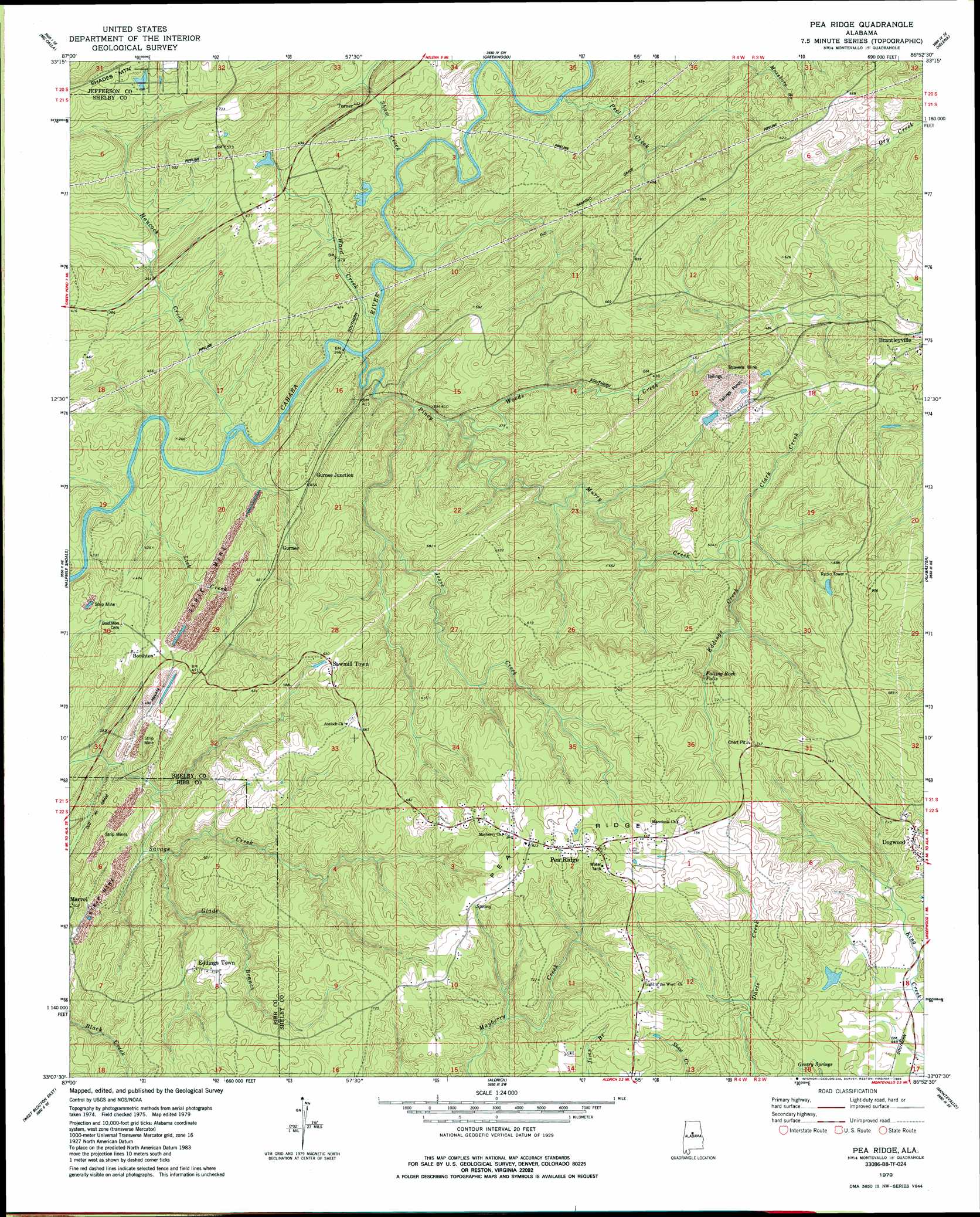
Pea Ridge Topo Map Alabama
To zoom in, hover over the map of Pea Ridge
USGS Topo Quad 33086b8 - 1:24,000 scale
| Topo Map Name: | Pea Ridge |
| USGS Topo Quad ID: | 33086b8 |
| Print Size: | ca. 21 1/4" wide x 27" high |
| Southeast Coordinates: | 33.125° N latitude / 86.875° W longitude |
| Map Center Coordinates: | 33.1875° N latitude / 86.9375° W longitude |
| U.S. State: | AL |
| Filename: | o33086b8.jpg |
| Download Map JPG Image: | Pea Ridge topo map 1:24,000 scale |
| Map Type: | Topographic |
| Topo Series: | 7.5´ |
| Map Scale: | 1:24,000 |
| Source of Map Images: | United States Geological Survey (USGS) |
| Alternate Map Versions: |
Montevallo NW AL 1975, updated 1977 Download PDF Buy paper map Pea Ridge AL 1979, updated 1980 Download PDF Buy paper map Pea Ridge AL 1979, updated 1986 Download PDF Buy paper map Pea Ridge AL 2011 Download PDF Buy paper map Pea Ridge AL 2014 Download PDF Buy paper map |
1:24,000 Topo Quads surrounding Pea Ridge
Oak Grove |
Concord |
Bessemer |
Birmingham South |
Cahaba Heights |
Abernant |
Mccalla |
Greenwood |
Helena |
Chelsea |
Woodstock |
Halfmile Shoals |
Pea Ridge |
Alabaster |
Bounds Lake |
West Blocton West |
West Blocton East |
Aldrich |
Montevallo |
Ozan |
Centreville West |
Centreville East |
Randolph |
Jemison West |
Jemison East |
> Back to 33086a1 at 1:100,000 scale
> Back to 33086a1 at 1:250,000 scale
> Back to U.S. Topo Maps home
Pea Ridge topo map: Gazetteer
Pea Ridge: Islands
Falling Rock elevation 224m 734′Pea Ridge: Mines
Barnes Mine elevation 167m 547′Boothton Mine elevation 178m 583′
Dogwood Mine elevation 195m 639′
Dogwood Number 3 Mine elevation 183m 600′
Gillispie Mine elevation 168m 551′
Glen Carbon Mine elevation 153m 501′
Gurnee Mine elevation 182m 597′
Rajah Mine elevation 206m 675′
Savage Creek Mine elevation 133m 436′
Sieard Mine elevation 172m 564′
Stravens Mine elevation 184m 603′
Whalley Mine (historical) elevation 136m 446′
Pea Ridge: Populated Places
Aden elevation 116m 380′Anita elevation 149m 488′
Boothton elevation 130m 426′
Eddings Town elevation 198m 649′
Garnsey Number 2 elevation 129m 423′
Glen Carbon elevation 166m 544′
Gurnee elevation 149m 488′
Gurnee Junction elevation 150m 492′
Lindseys Crossing elevation 149m 488′
Pea Ridge elevation 253m 830′
Sawmill Town elevation 183m 600′
Straven elevation 156m 511′
Superior elevation 124m 406′
Tulse elevation 153m 501′
Turner elevation 114m 374′
Pea Ridge: Ridges
Pea Ridge elevation 244m 800′Pea Ridge: Springs
Gentry Springs elevation 160m 524′Pea Ridge: Streams
Glade Branch elevation 139m 456′Hancock Creek elevation 102m 334′
Hurricane Creek elevation 115m 377′
Jesse Creek elevation 139m 456′
Lick Creek elevation 99m 324′
Murry Creek elevation 124m 406′
Peel Creek elevation 109m 357′
Piney Woods Creek elevation 130m 426′
Shaw Creek elevation 103m 337′
Ward Creek elevation 102m 334′
Pea Ridge digital topo map on disk
Buy this Pea Ridge topo map showing relief, roads, GPS coordinates and other geographical features, as a high-resolution digital map file on DVD: