West Blocton East Topo Map Alabama
To zoom in, hover over the map of West Blocton East
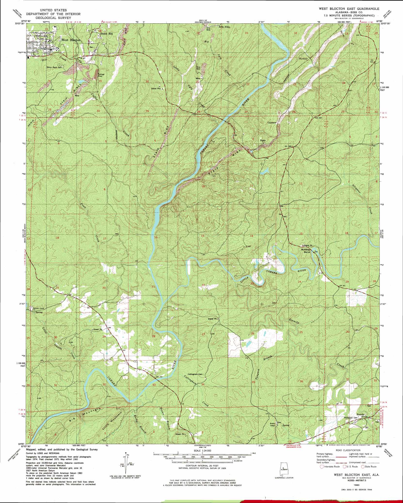
USGS Topo Quad 33087a1 - 1:24,000 scale
| Topo Map Name: | West Blocton East |
| USGS Topo Quad ID: | 33087a1 |
| Print Size: | ca. 21 1/4" wide x 27" high |
| Southeast Coordinates: | 33° N latitude / 87° W longitude |
| Map Center Coordinates: | 33.0625° N latitude / 87.0625° W longitude |
| U.S. State: | AL |
| Filename: | o33087a1.jpg |
| Download Map JPG Image: | West Blocton East topo map 1:24,000 scale |
| Map Type: | Topographic |
| Topo Series: | 7.5´ |
| Map Scale: | 1:24,000 |
| Source of Map Images: | United States Geological Survey (USGS) |
| Alternate Map Versions: |
West Blocton East AL 1980, updated 1980 Download PDF Buy paper map West Blocton East AL 1980, updated 1980 Download PDF Buy paper map West Blocton East AL 2011 Download PDF Buy paper map West Blocton East AL 2014 Download PDF Buy paper map |
1:24,000 Topo Quads surrounding West Blocton East
Brookwood |
Abernant |
Mccalla |
Greenwood |
Helena |
Coaling |
Woodstock |
Halfmile Shoals |
Pea Ridge |
Alabaster |
Pearson |
West Blocton West |
West Blocton East |
Aldrich |
Montevallo |
Pondville |
Centreville West |
Centreville East |
Randolph |
Jemison West |
Heiberger |
Harrisburg |
Oakmulgee |
Maplesville West |
Maplesville East |
> Back to 33087a1 at 1:100,000 scale
> Back to 33086a1 at 1:250,000 scale
> Back to U.S. Topo Maps home
West Blocton East topo map: Gazetteer
West Blocton East: Bends
Bulldog Bend elevation 83m 272′West Blocton East: Bridges
Pratt Ferry Bridge elevation 63m 206′West Blocton East: Crossings
Blake Ford elevation 67m 219′Island Ford elevation 81m 265′
Light Ford elevation 67m 219′
Pine Island Ford elevation 75m 246′
Pratt Ferry (historical) elevation 100m 328′
Richs Ford elevation 92m 301′
West Blocton East: Dams
Kimberly Clark Paper Company Lake Dam elevation 149m 488′Serene Lake Number 7 Dam elevation 87m 285′
West Blocton East: Mines
Confederate Mine elevation 173m 567′Gardner Mine elevation 106m 347′
West Blocton East: Parks
Cahaba Wildlife Management Area elevation 148m 485′West Blocton East: Populated Places
Belle Ellen elevation 103m 337′Blocton (historical) elevation 117m 383′
Bucktown (historical) elevation 140m 459′
Coleanor elevation 149m 488′
Corinne (historical) elevation 123m 403′
Flat Top elevation 159m 521′
Hawkinsville (historical) elevation 171m 561′
Italian Town elevation 123m 403′
Nash Town (historical) elevation 98m 321′
Piper elevation 155m 508′
Seymour elevation 126m 413′
Sixmile elevation 108m 354′
Smith Hill elevation 160m 524′
Stacks Hill (historical) elevation 123m 403′
West Blocton elevation 151m 495′
West Blocton East: Rapids
Hargrove Shoals elevation 70m 229′West Blocton East: Reservoirs
Kimberly Clark Paper Company Lake elevation 149m 488′Serene Lake Number 7 elevation 87m 285′
West Blocton East: Springs
Schultz Creek Church Spring elevation 98m 321′West Blocton East: Streams
Alligator Creek elevation 89m 291′Big Ugly Creek elevation 94m 308′
Brown Branch elevation 66m 216′
Caffee Creek elevation 70m 229′
Cottingham Creek elevation 65m 213′
Hill Creek elevation 114m 374′
Little Cahaba River elevation 67m 219′
Little Schultz Creek elevation 68m 223′
Little Ugly Creek elevation 83m 272′
Pine Island Creek elevation 91m 298′
Pratt Creek elevation 64m 209′
Rocky Branch elevation 65m 213′
Sixmile Creek elevation 71m 232′
Tanyard Branch elevation 83m 272′
West Blocton East: Summits
Big Mountain elevation 154m 505′Little Mountain elevation 134m 439′
West Blocton East digital topo map on disk
Buy this West Blocton East topo map showing relief, roads, GPS coordinates and other geographical features, as a high-resolution digital map file on DVD: