Montevallo Topo Map Alabama
To zoom in, hover over the map of Montevallo
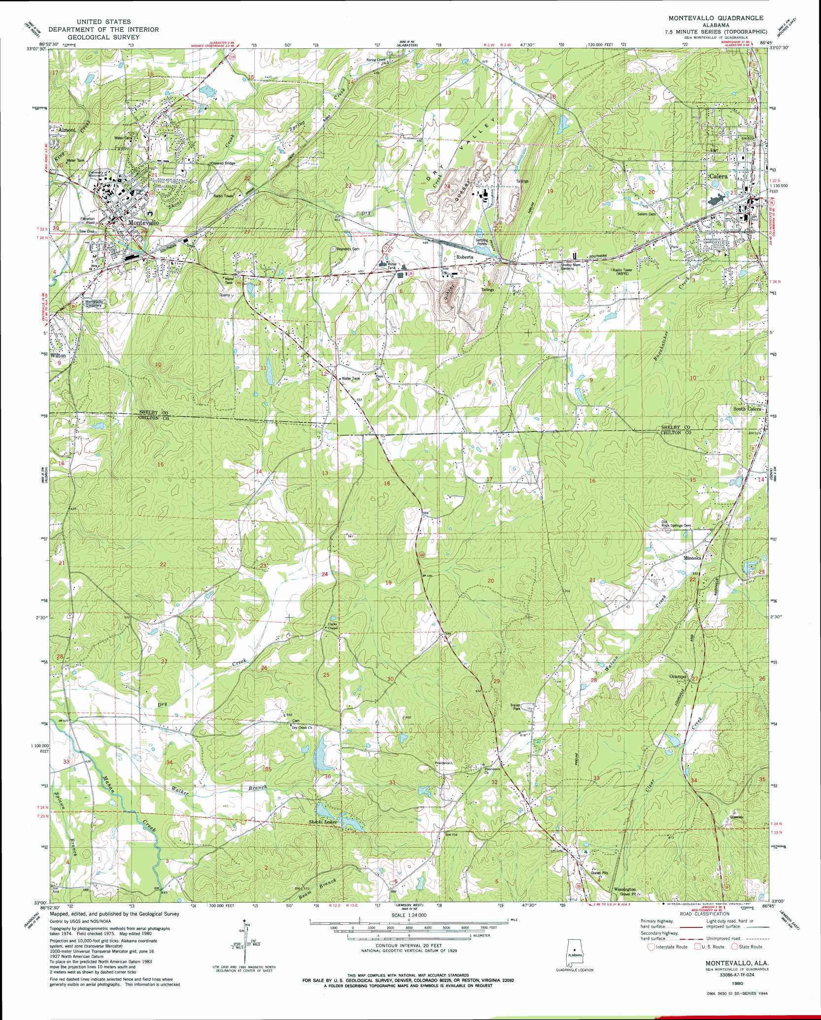
USGS Topo Quad 33086a7 - 1:24,000 scale
| Topo Map Name: | Montevallo |
| USGS Topo Quad ID: | 33086a7 |
| Print Size: | ca. 21 1/4" wide x 27" high |
| Southeast Coordinates: | 33° N latitude / 86.75° W longitude |
| Map Center Coordinates: | 33.0625° N latitude / 86.8125° W longitude |
| U.S. State: | AL |
| Filename: | o33086a7.jpg |
| Download Map JPG Image: | Montevallo topo map 1:24,000 scale |
| Map Type: | Topographic |
| Topo Series: | 7.5´ |
| Map Scale: | 1:24,000 |
| Source of Map Images: | United States Geological Survey (USGS) |
| Alternate Map Versions: |
Montevallo SE AL 1975, updated 1977 Download PDF Buy paper map Montevallo AL 1980, updated 1980 Download PDF Buy paper map Montevallo AL 1980, updated 1987 Download PDF Buy paper map Montevallo AL 1980, updated 1987 Download PDF Buy paper map Montevallo AL 2011 Download PDF Buy paper map Montevallo AL 2014 Download PDF Buy paper map |
1:24,000 Topo Quads surrounding Montevallo
Mccalla |
Greenwood |
Helena |
Chelsea |
Westover |
Halfmile Shoals |
Pea Ridge |
Alabaster |
Bounds Lake |
Columbiana |
West Blocton East |
Aldrich |
Montevallo |
Ozan |
Shelby |
Centreville East |
Randolph |
Jemison West |
Jemison East |
Lay Dam |
Oakmulgee |
Maplesville West |
Maplesville East |
Clanton West |
Clanton East |
> Back to 33086a1 at 1:100,000 scale
> Back to 33086a1 at 1:250,000 scale
> Back to U.S. Topo Maps home
Montevallo topo map: Gazetteer
Montevallo: Crossings
Curry Ford elevation 128m 419′Montevallo: Dams
J H Oliver Lake Dam elevation 131m 429′Jim Oliver Pond Dam elevation 164m 538′
Moores Lake Dam elevation 171m 561′
Nazarene Church Camp Lake Dam elevation 161m 528′
Shechi Lake Dam elevation 191m 626′
Montevallo: Parks
Richard Gilliam Field elevation 126m 413′University of Montevallo Historic District elevation 137m 449′
Montevallo: Populated Places
Calera elevation 154m 505′Dry Valley elevation 167m 547′
Minooka elevation 184m 603′
Montevallo elevation 125m 410′
Ocampo elevation 170m 557′
Roberta elevation 148m 485′
Valley Junction elevation 171m 561′
Wessington elevation 194m 636′
Montevallo: Post Offices
Calera Post Office elevation 155m 508′Hales Newala Post Office (historical) elevation 148m 485′
Montevallo Post Office (historical) elevation 123m 403′
Newala Post Office (historical) elevation 148m 485′
Montevallo: Reservoirs
J H Oliver Lake elevation 131m 429′Jim Oliver Pond elevation 164m 538′
Moores Lake elevation 171m 561′
Salter Lake elevation 161m 528′
Shechi Lake Number One elevation 191m 626′
Shechi Lakes elevation 160m 524′
Montevallo: Springs
Alexander Springs elevation 140m 459′Big Spring elevation 118m 387′
Shoal Creek Spring elevation 121m 396′
Simpson Spring elevation 162m 531′
Montevallo: Streams
Davis Creek elevation 115m 377′Dry Creek elevation 131m 429′
King Creek elevation 126m 413′
Spring Creek elevation 127m 416′
Montevallo: Valleys
Dry Valley elevation 126m 413′Montevallo digital topo map on disk
Buy this Montevallo topo map showing relief, roads, GPS coordinates and other geographical features, as a high-resolution digital map file on DVD: