Lake Nicol Topo Map Alabama
To zoom in, hover over the map of Lake Nicol
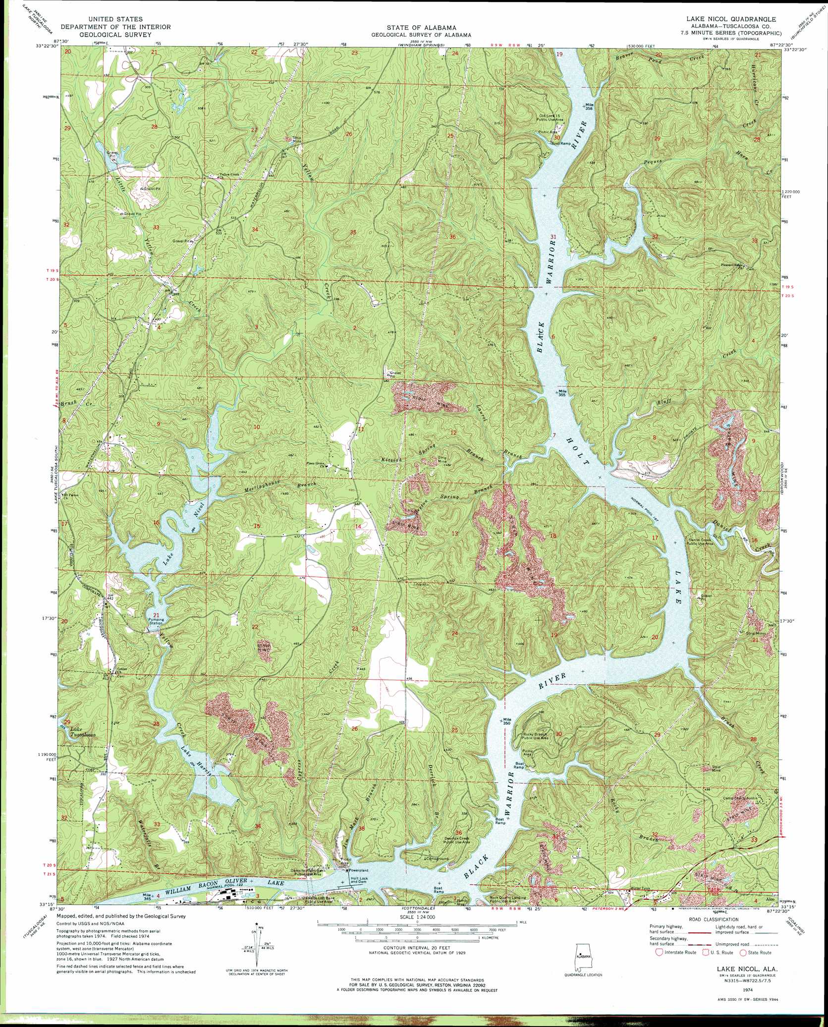
USGS Topo Quad 33087c4 - 1:24,000 scale
| Topo Map Name: | Lake Nicol |
| USGS Topo Quad ID: | 33087c4 |
| Print Size: | ca. 21 1/4" wide x 27" high |
| Southeast Coordinates: | 33.25° N latitude / 87.375° W longitude |
| Map Center Coordinates: | 33.3125° N latitude / 87.4375° W longitude |
| U.S. State: | AL |
| Filename: | o33087c4.jpg |
| Download Map JPG Image: | Lake Nicol topo map 1:24,000 scale |
| Map Type: | Topographic |
| Topo Series: | 7.5´ |
| Map Scale: | 1:24,000 |
| Source of Map Images: | United States Geological Survey (USGS) |
| Alternate Map Versions: |
Lake Nicol AL 1974, updated 1974 Download PDF Buy paper map Lake Nicol AL 2011 Download PDF Buy paper map Lake Nicol AL 2014 Download PDF Buy paper map |
1:24,000 Topo Quads surrounding Lake Nicol
New Lexington |
Berry Se |
Wiley |
Tutwiler School |
Gilmore |
Gin Creek |
Lake Tuscaloosa North |
Windham Springs |
Burchfield Store |
Oak Grove |
Lake Lurleen |
Lake Tuscaloosa South |
Lake Nicol |
Brookwood |
Abernant |
Coker |
Tuscaloosa |
Cottondale |
Coaling |
Woodstock |
Fosters |
Englewood |
Duncanville |
Pearson |
West Blocton West |
> Back to 33087a1 at 1:100,000 scale
> Back to 33086a1 at 1:250,000 scale
> Back to U.S. Topo Maps home
Lake Nicol topo map: Gazetteer
Lake Nicol: Bars
Arnolds Shoal (historical) elevation 57m 187′Flemons Shoal (historical) elevation 57m 187′
Hog Shoals elevation 38m 124′
Langstons Shoal (historical) elevation 57m 187′
Mossy Shoal (historical) elevation 57m 187′
Rose Shoal (historical) elevation 57m 187′
Sellers Shoal (historical) elevation 57m 187′
Sniders Shoal (historical) elevation 57m 187′
Wards Shoal (historical) elevation 57m 187′
Lake Nicol: Crossings
Hollis Ferry (historical) elevation 57m 187′Wallace Ferry (historical) elevation 57m 187′
Lake Nicol: Dams
Cunningham Number 1 Dam elevation 125m 410′Holt Lock and Dam elevation 57m 187′
Lake Harris Dam elevation 58m 190′
Lake Nicol Dam elevation 87m 285′
Lock Number Five (historical) elevation 57m 187′
Lock Number Six (historical) elevation 57m 187′
Yacht Club Bay Dam Number 15 elevation 108m 354′
Lake Nicol: Islands
Rock Island (historical) elevation 38m 124′Lake Nicol: Lakes
Scales Lake elevation 57m 187′Lake Nicol: Parks
Damsite Left Bank Recreation Area elevation 59m 193′Daniel Creek Public Use Area elevation 104m 341′
Deerlick Creek Public Use Area elevation 74m 242′
Holt Damsite-Left Bank Public Use Area elevation 71m 232′
Holt Damsite-Right Bank Public Use Area elevation 76m 249′
Old Lock 15 Public Use Area elevation 87m 285′
Rock Quarry Landing Public Use Area elevation 72m 236′
Rocky Branch Public Use Area elevation 74m 242′
Lake Nicol: Populated Places
Lakeridge elevation 108m 354′Lexington Downs elevation 112m 367′
Lake Nicol: Reservoirs
Holt Lake elevation 57m 187′Lake Harris elevation 63m 206′
Lake Nicol elevation 87m 285′
Yacht Club Bay Lake Number 15 elevation 108m 354′
Lake Nicol: Streams
Beaver Pond Creek elevation 57m 187′Bluff Creek elevation 57m 187′
Brush Creek elevation 57m 187′
Cypress Creek elevation 42m 137′
Daniel Creek elevation 57m 187′
Deerlick Branch elevation 57m 187′
Douthys Spring Branch elevation 57m 187′
Horn Creek elevation 66m 216′
Hurricane Creek elevation 79m 259′
Hurricane Creek elevation 38m 124′
Jim Mack Branch elevation 57m 187′
Kizziah Spring Branch elevation 57m 187′
Laurel Branch elevation 57m 187′
Lick Branch elevation 57m 187′
Little Yellow Creek elevation 90m 295′
Meetinghouse Branch elevation 87m 285′
Peques Creek elevation 57m 187′
Rocky Branch elevation 57m 187′
Sexton Spring Branch elevation 71m 232′
Waterfalls Branch elevation 39m 127′
Yellow Creek elevation 38m 124′
Lake Nicol digital topo map on disk
Buy this Lake Nicol topo map showing relief, roads, GPS coordinates and other geographical features, as a high-resolution digital map file on DVD: