Fosters Topo Map Alabama
To zoom in, hover over the map of Fosters
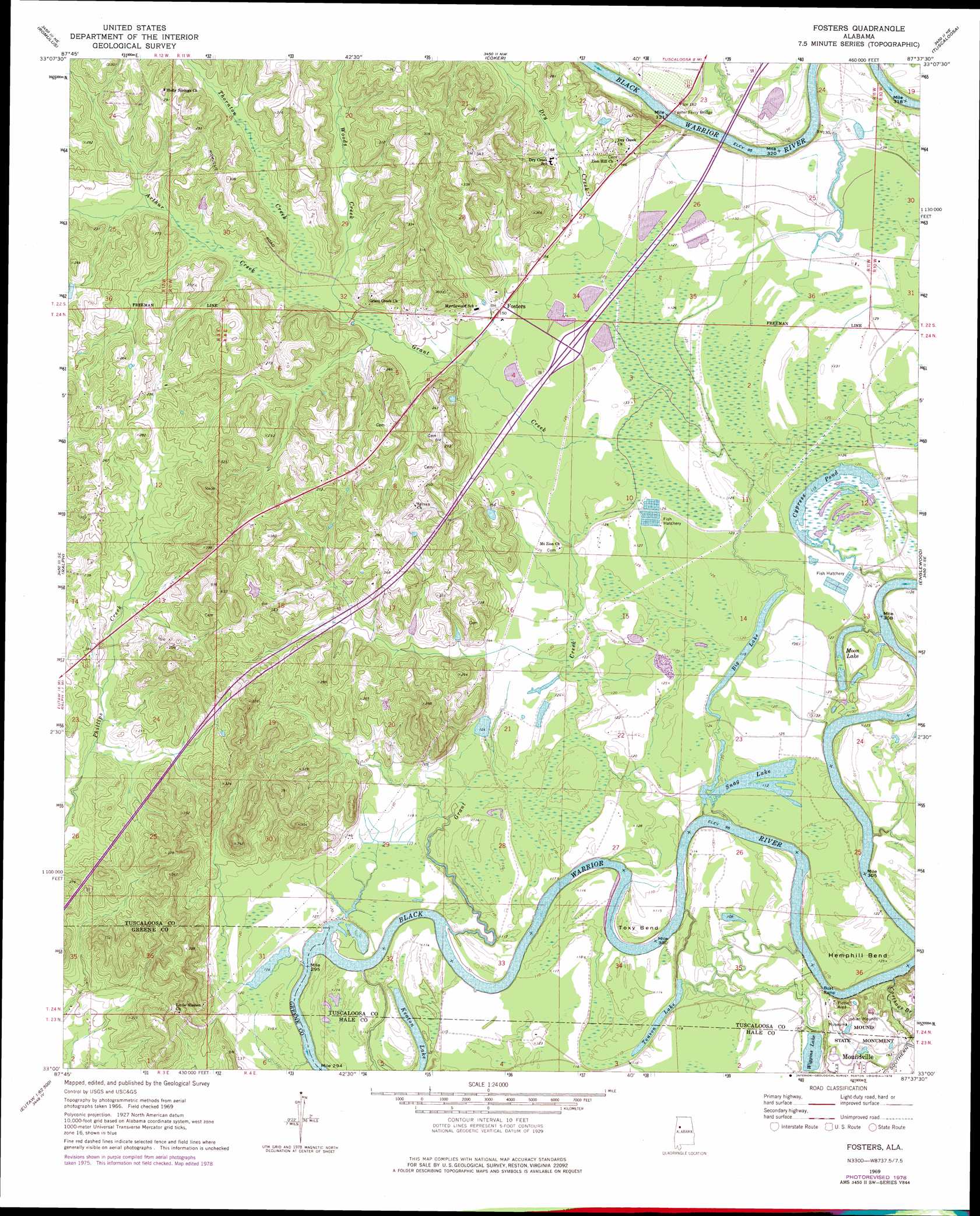
USGS Topo Quad 33087a6 - 1:24,000 scale
| Topo Map Name: | Fosters |
| USGS Topo Quad ID: | 33087a6 |
| Print Size: | ca. 21 1/4" wide x 27" high |
| Southeast Coordinates: | 33° N latitude / 87.625° W longitude |
| Map Center Coordinates: | 33.0625° N latitude / 87.6875° W longitude |
| U.S. State: | AL |
| Filename: | o33087a6.jpg |
| Download Map JPG Image: | Fosters topo map 1:24,000 scale |
| Map Type: | Topographic |
| Topo Series: | 7.5´ |
| Map Scale: | 1:24,000 |
| Source of Map Images: | United States Geological Survey (USGS) |
| Alternate Map Versions: |
Fosters AL 1969, updated 1973 Download PDF Buy paper map Fosters AL 1969, updated 1978 Download PDF Buy paper map Fosters AL 2011 Download PDF Buy paper map Fosters AL 2014 Download PDF Buy paper map |
1:24,000 Topo Quads surrounding Fosters
Gordo |
Elrod |
Lake Lurleen |
Lake Tuscaloosa South |
Lake Nicol |
Kirk |
Romulus |
Coker |
Tuscaloosa |
Cottondale |
Mantua |
Ralph |
Fosters |
Englewood |
Duncanville |
Union |
Knoxville |
Moundville West |
Moundville East |
Payne Lake |
Eutaw |
Warrior Dam |
Sawyerville |
Ingram |
Hogglesville |
> Back to 33087a1 at 1:100,000 scale
> Back to 33086a1 at 1:250,000 scale
> Back to U.S. Topo Maps home
Fosters topo map: Gazetteer
Fosters: Bars
Beals Bar elevation 29m 95′Bohannons Bar elevation 29m 95′
Buzzards Bar elevation 30m 98′
Fosters Bar elevation 29m 95′
Izzard Shoals elevation 32m 104′
Lewis Bar elevation 29m 95′
Mud Bar elevation 29m 95′
Twentyone Mile Bar elevation 29m 95′
Vancleave Bar elevation 29m 95′
Wild Horse Bar elevation 32m 104′
Fosters: Bends
Big Sandy Cutoff elevation 35m 114′Eddins Cutoff elevation 34m 111′
Hemphill Bend elevation 35m 114′
Toxy Bend elevation 34m 111′
Wilford Bend elevation 34m 111′
Fosters: Bridges
Foster Ferry Bridge elevation 29m 95′Fosters: Crossings
Interchange 62 elevation 39m 127′Kings Ferry (historical) elevation 29m 95′
Fosters: Dams
Big Cypress Lake Dam elevation 35m 114′Lake Gloria Dam elevation 38m 124′
Snag Lake Dam elevation 34m 111′
Wiggins Lake Dam elevation 38m 124′
Fosters: Lakes
Big Lake elevation 35m 114′Cypress Pond elevation 35m 114′
Keaton Lake elevation 29m 95′
Moon Lake elevation 29m 95′
Snag Lake elevation 34m 111′
Touson Lake elevation 32m 104′
Wiggins Lake elevation 38m 124′
Fosters: Parks
Mound State Monument elevation 48m 157′Moundville State Monument elevation 48m 157′
Fosters: Populated Places
Fosters elevation 46m 150′Mountainbrook elevation 74m 242′
Sylvan elevation 81m 265′
Fosters: Post Offices
Fosters Post Office elevation 48m 157′Fosters: Reservoirs
Lake Gloria elevation 38m 124′Fosters: Streams
Arthur Creek elevation 46m 150′Carthage Branch elevation 29m 95′
Dry Creek elevation 38m 124′
Grant Creek elevation 29m 95′
Thornton Creek elevation 46m 150′
Woods Creek elevation 45m 147′
Fosters digital topo map on disk
Buy this Fosters topo map showing relief, roads, GPS coordinates and other geographical features, as a high-resolution digital map file on DVD: