Wright Patman Dam Topo Map Texas
To zoom in, hover over the map of Wright Patman Dam
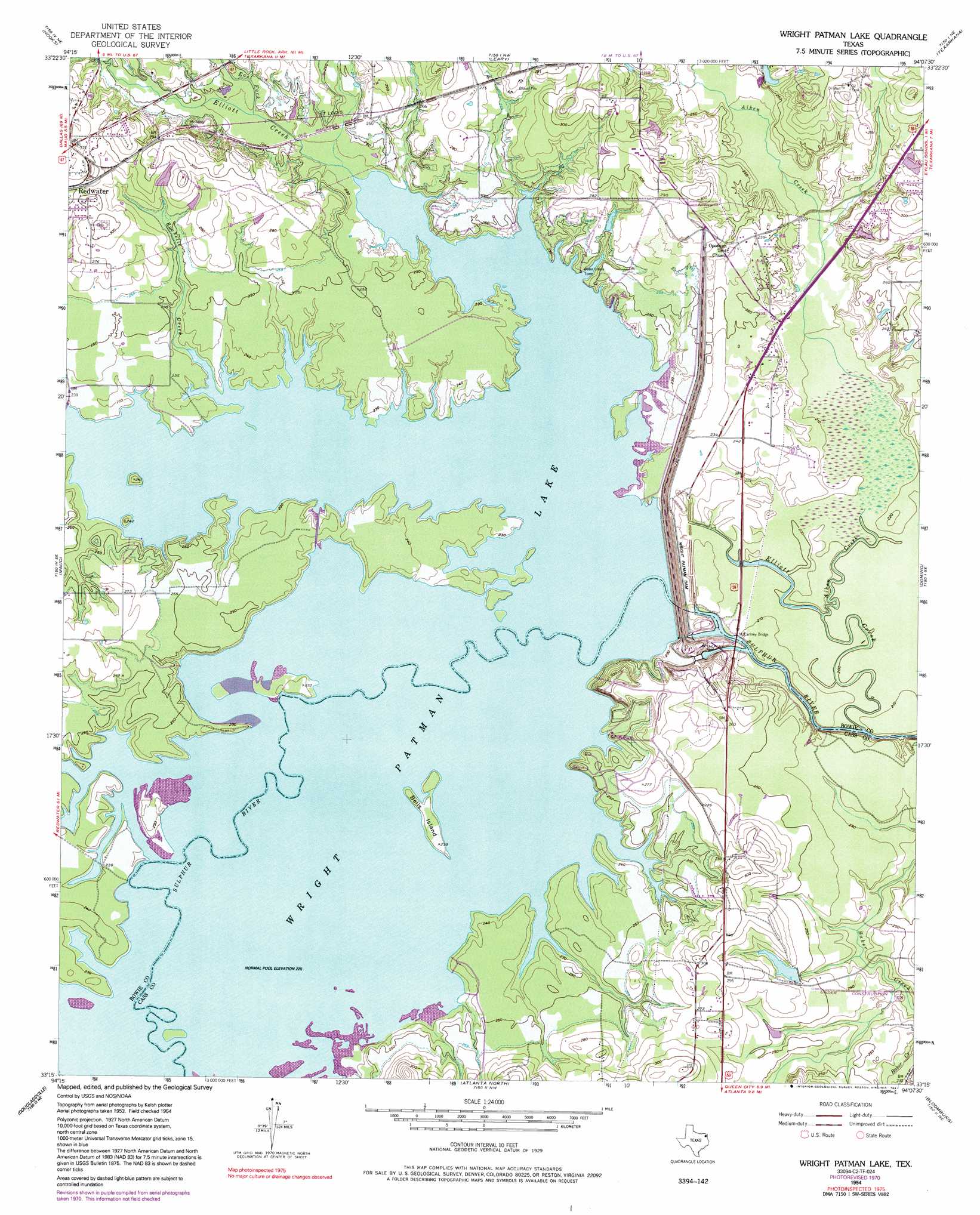
USGS Topo Quad 33094c2 - 1:24,000 scale
| Topo Map Name: | Wright Patman Dam |
| USGS Topo Quad ID: | 33094c2 |
| Print Size: | ca. 21 1/4" wide x 27" high |
| Southeast Coordinates: | 33.25° N latitude / 94.125° W longitude |
| Map Center Coordinates: | 33.3125° N latitude / 94.1875° W longitude |
| U.S. State: | TX |
| Filename: | o33094c2.jpg |
| Download Map JPG Image: | Wright Patman Dam topo map 1:24,000 scale |
| Map Type: | Topographic |
| Topo Series: | 7.5´ |
| Map Scale: | 1:24,000 |
| Source of Map Images: | United States Geological Survey (USGS) |
| Alternate Map Versions: |
Lake Texarkana TX 1954, updated 1955 Download PDF Buy paper map Lake Texarkana TX 1954, updated 1968 Download PDF Buy paper map Lake Texarkana TX 1954, updated 1971 Download PDF Buy paper map Lake Texarkana TX 1954, updated 1975 Download PDF Buy paper map Wright Patman Lake TX 1954, updated 1983 Download PDF Buy paper map Wright Patman Lake TX 1954, updated 1991 Download PDF Buy paper map Wright Patman Lake TX 2010 Download PDF Buy paper map Wright Patman Lake TX 2013 Download PDF Buy paper map Wright Patman Lake TX 2016 Download PDF Buy paper map |
1:24,000 Topo Quads surrounding Wright Patman Dam
Daniels Chapel |
Redbank |
Barkman |
Ogden |
Homan |
New Boston |
Hooks |
Leary |
Texarkana |
Mandeville |
Corley |
Maud |
Wright Patman Dam |
Domino |
Fouke |
Bryans Mill |
Douglassville |
Atlanta North |
Bloomburg |
Doddridge Nw |
Carterville |
Linden |
Atlanta South |
Ravanna |
Doddridge |
> Back to 33094a1 at 1:100,000 scale
> Back to 33094a1 at 1:250,000 scale
> Back to U.S. Topo Maps home
Wright Patman Dam topo map: Gazetteer
Wright Patman Dam: Bridges
McCartney Bridge elevation 61m 200′Wright Patman Dam: Dams
Caver Lake Dam elevation 75m 246′Texarkana Dam elevation 83m 272′
Wright Patman Dam elevation 69m 226′
Wright Patman Dam: Islands
Bells Island elevation 70m 229′Wright Patman Dam: Parks
Big Creek Park elevation 76m 249′Clear Spring Park elevation 78m 255′
Kelly Creek Park elevation 78m 255′
Rocky Point Park elevation 87m 285′
Wright Patman Dam: Reservoirs
Caver Lake elevation 75m 246′Wright Patman Lake elevation 80m 262′
Wright Patman Dam: Streams
Akin Creek elevation 61m 200′Boone Creek elevation 69m 226′
Day Creek elevation 69m 226′
East Fork Elliott Creek elevation 73m 239′
Elliott Creek elevation 61m 200′
Fleming Creek elevation 69m 226′
Rochelle Creek elevation 69m 226′
Wright Patman Dam: Trails
Rocky Point Park Trail elevation 74m 242′Wright Patman Dam digital topo map on disk
Buy this Wright Patman Dam topo map showing relief, roads, GPS coordinates and other geographical features, as a high-resolution digital map file on DVD: