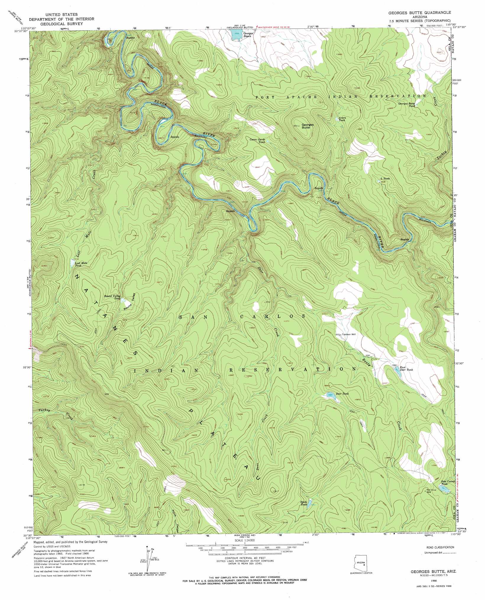
Georges Butte Topo Map Arizona
To zoom in, hover over the map of Georges Butte
USGS Topo Quad 33110e1 - 1:24,000 scale
| Topo Map Name: | Georges Butte |
| USGS Topo Quad ID: | 33110e1 |
| Print Size: | ca. 21 1/4" wide x 27" high |
| Southeast Coordinates: | 33.5° N latitude / 110° W longitude |
| Map Center Coordinates: | 33.5625° N latitude / 110.0625° W longitude |
| U.S. State: | AZ |
| Filename: | o33110e1.jpg |
| Download Map JPG Image: | Georges Butte topo map 1:24,000 scale |
| Map Type: | Topographic |
| Topo Series: | 7.5´ |
| Map Scale: | 1:24,000 |
| Source of Map Images: | United States Geological Survey (USGS) |
| Alternate Map Versions: |
Georges Butte AZ 1966, updated 1967 Download PDF Buy paper map Georges Butte AZ 1966, updated 1967 Download PDF Buy paper map Georges Butte AZ 2011 Download PDF Buy paper map Georges Butte AZ 2014 Download PDF Buy paper map |
1:24,000 Topo Quads surrounding Georges Butte
Carrizo Se |
Cone Butte |
Canyon Day |
Whiteriver |
Corn Creek Plateau |
Popcorn Canyon |
Forks Butte |
Velasquez Butte |
Bonito Prairie |
Corn Creek |
Sontag Creek |
Chiricahua Butte |
Georges Butte |
Elwood Canyon |
West Poker Mountain |
Sontag Mesa |
Bronco Gulch |
Ash Creek Ne |
Natanes Mountains Nw |
Natanes Mountains Ne |
Mount Triplet |
Branaman Spring |
Ash Creek Ranch |
Tule Tubs |
Point Of Pines West |
> Back to 33110e1 at 1:100,000 scale
> Back to 33110a1 at 1:250,000 scale
> Back to U.S. Topo Maps home
Georges Butte topo map: Gazetteer
Georges Butte: Basins
Round Valley elevation 0m 0′Georges Butte: Reservoirs
Acorn Tank elevation 1729m 5672′Cerro Gordo Tank elevation 1672m 5485′
Deer Tank elevation 1727m 5666′
East Deer Tank elevation 1729m 5672′
Georges Butte Tank elevation 1705m 5593′
L Tank elevation 1717m 5633′
Lost Mule Tank elevation 1739m 5705′
Pole Corral Tank elevation 1804m 5918′
Round Valley Tank elevation 0m 0′
Steele Tank elevation 1804m 5918′
Georges Butte: Streams
Banty Creek elevation 1632m 5354′Deer Creek elevation 1530m 5019′
Lost Mule Creek elevation 1470m 4822′
Georges Butte: Summits
Georges Butte elevation 1920m 6299′Georges Butte: Wells
Foreman Well elevation 1701m 5580′Georges Butte digital topo map on disk
Buy this Georges Butte topo map showing relief, roads, GPS coordinates and other geographical features, as a high-resolution digital map file on DVD: