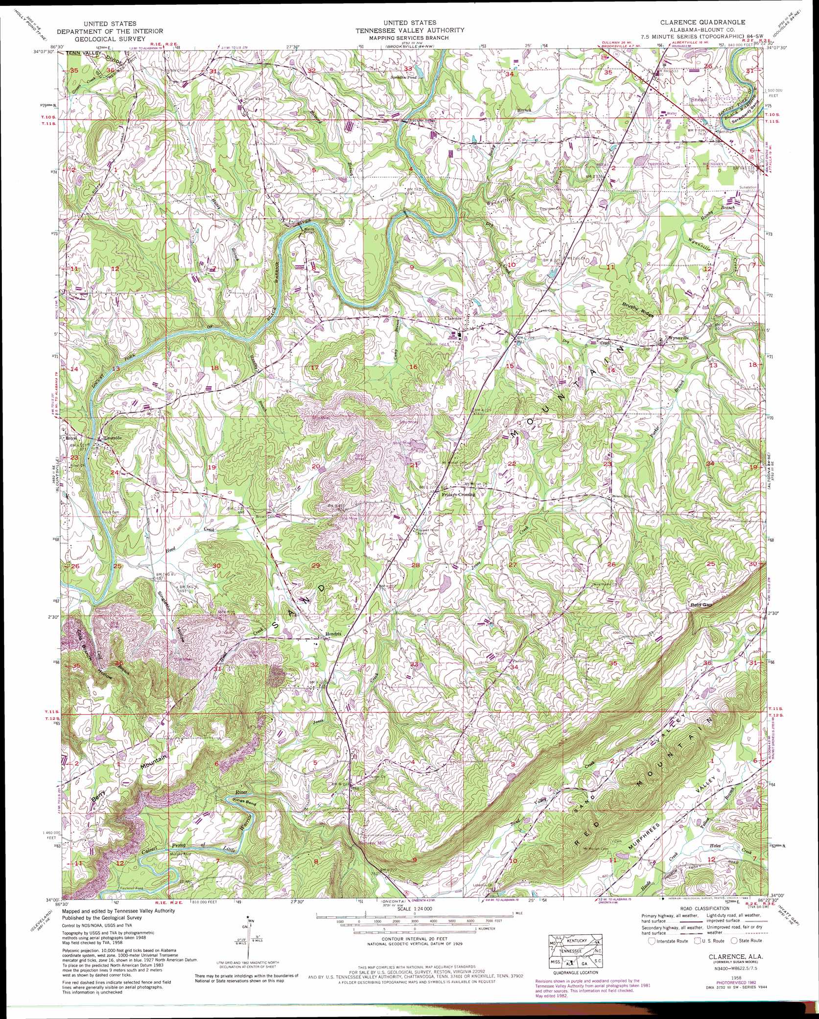
Clarence Topo Map Alabama
To zoom in, hover over the map of Clarence
USGS Topo Quad 34086a4 - 1:24,000 scale
| Topo Map Name: | Clarence |
| USGS Topo Quad ID: | 34086a4 |
| Print Size: | ca. 21 1/4" wide x 27" high |
| Southeast Coordinates: | 34° N latitude / 86.375° W longitude |
| Map Center Coordinates: | 34.0625° N latitude / 86.4375° W longitude |
| U.S. State: | AL |
| Filename: | o34086a4.jpg |
| Download Map JPG Image: | Clarence topo map 1:24,000 scale |
| Map Type: | Topographic |
| Topo Series: | 7.5´ |
| Map Scale: | 1:24,000 |
| Source of Map Images: | United States Geological Survey (USGS) |
| Alternate Map Versions: |
Susan Moore AL 1958, updated 1960 Download PDF Buy paper map Clarence AL 1958, updated 1976 Download PDF Buy paper map Clarence AL 1958, updated 1983 Download PDF Buy paper map Susan Moore AL 1975, updated 1977 Download PDF Buy paper map Clarence AL 1975, updated 1979 Download PDF Buy paper map Clarence AL 2011 Download PDF Buy paper map Clarence AL 2014 Download PDF Buy paper map |
1:24,000 Topo Quads surrounding Clarence
Lawrence Cove |
Hulaco |
Arab |
Guntersville |
Albertville |
Simcoe |
Holly Pond |
Brooksville |
Douglas |
Boaz |
Garden City |
Blountsville |
Clarence |
Altoona |
Howelton |
Nectar |
Cleveland |
Oneonta |
Hyatt Gap |
Steele |
Trafford |
Remlap |
Springville |
Ashville |
Cox Gap |
> Back to 34086a1 at 1:100,000 scale
> Back to 34086a1 at 1:250,000 scale
> Back to U.S. Topo Maps home
Clarence topo map: Gazetteer
Clarence: Bends
Kings Bend elevation 222m 728′Sprayberry Bend elevation 237m 777′
Clarence: Bridges
Horton Mill Bridge elevation 222m 728′Stracener Bridge elevation 222m 728′
Wards Bridge elevation 204m 669′
Clarence: Crossings
Faulkner Ford elevation 196m 643′Murphy Ford elevation 201m 659′
Clarence: Dams
Kenneth Wright Dam elevation 249m 816′Clarence: Gaps
Reid Gap elevation 361m 1184′Clarence: Mines
Hendrix Mine elevation 245m 803′Scott Road Mine elevation 238m 780′
Clarence: Populated Places
Bird (historical) elevation 286m 938′Craig (historical) elevation 235m 770′
Fridays Crossing elevation 247m 810′
Hendrix elevation 230m 754′
Hortons Mill elevation 278m 912′
Riverside elevation 205m 672′
Snead elevation 242m 793′
Susan Moore elevation 232m 761′
Wynnville elevation 260m 853′
Clarence: Post Offices
Snead Post Office elevation 238m 780′Clarence: Reservoirs
Spradlin Pond elevation 233m 764′Wrights Lake elevation 249m 816′
Clarence: Ridges
Brushy Ridge elevation 280m 918′Clarence: Streams
Buzzard Branch elevation 205m 672′Camp Branch elevation 206m 675′
Cold Branch elevation 195m 639′
Dry Creek elevation 219m 718′
Hales Creek elevation 247m 810′
Hamby Branch elevation 229m 751′
Handley Branch elevation 201m 659′
Honey Branch elevation 201m 659′
Hood Creek elevation 195m 639′
Jones Creek elevation 207m 679′
Parker Branch elevation 237m 777′
Rocky Branch elevation 211m 692′
Sand Valley Creek elevation 225m 738′
Whippoorwill Creek elevation 208m 682′
Wynnville Creek elevation 260m 853′
Yellow Branch elevation 247m 810′
Clarence: Valleys
Cold Branch Hollow elevation 197m 646′Singleton Hollow elevation 197m 646′
Clarence digital topo map on disk
Buy this Clarence topo map showing relief, roads, GPS coordinates and other geographical features, as a high-resolution digital map file on DVD: