Nectar Topo Map Alabama
To zoom in, hover over the map of Nectar
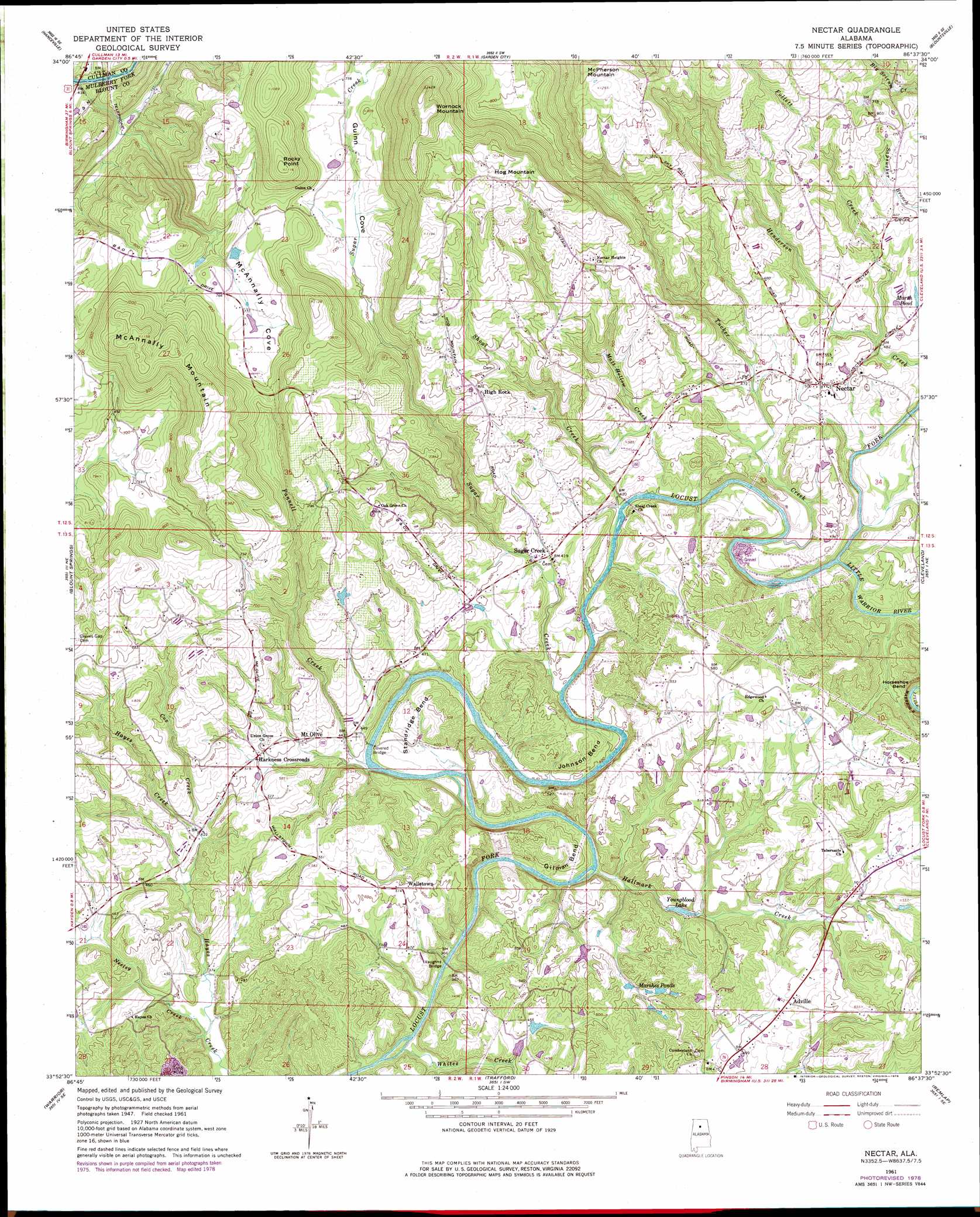
USGS Topo Quad 33086h6 - 1:24,000 scale
| Topo Map Name: | Nectar |
| USGS Topo Quad ID: | 33086h6 |
| Print Size: | ca. 21 1/4" wide x 27" high |
| Southeast Coordinates: | 33.875° N latitude / 86.625° W longitude |
| Map Center Coordinates: | 33.9375° N latitude / 86.6875° W longitude |
| U.S. State: | AL |
| Filename: | o33086h6.jpg |
| Download Map JPG Image: | Nectar topo map 1:24,000 scale |
| Map Type: | Topographic |
| Topo Series: | 7.5´ |
| Map Scale: | 1:24,000 |
| Source of Map Images: | United States Geological Survey (USGS) |
| Alternate Map Versions: |
Nectar AL 1961, updated 1963 Download PDF Buy paper map Nectar AL 1961, updated 1978 Download PDF Buy paper map Nectar AL 1961, updated 1978 Download PDF Buy paper map Nectar AL 1975, updated 1977 Download PDF Buy paper map Nectar AL 2011 Download PDF Buy paper map Nectar AL 2014 Download PDF Buy paper map |
1:24,000 Topo Quads surrounding Nectar
West Point |
Cullman |
Simcoe |
Holly Pond |
Brooksville |
Trimble |
Hanceville |
Garden City |
Blountsville |
Clarence |
Arkadelphia |
Blount Springs |
Nectar |
Cleveland |
Oneonta |
Creel |
Warrior |
Trafford |
Remlap |
Springville |
Brookside |
Gardendale |
Pinson |
Argo |
Odenville |
> Back to 33086e1 at 1:100,000 scale
> Back to 33086a1 at 1:250,000 scale
> Back to U.S. Topo Maps home
Nectar topo map: Gazetteer
Nectar: Bends
Gilman Bend elevation 148m 485′Johnson Bend elevation 151m 495′
Standridge Bend elevation 141m 462′
Nectar: Bridges
Nectar Covered Bridge elevation 121m 396′Vaughns Bridge elevation 104m 341′
Nectar: Crossings
Copeland Ford elevation 140m 459′Smith Ford elevation 121m 396′
Nectar: Dams
Hagwood Dam elevation 143m 469′Johnson Farm Lake Dam elevation 181m 593′
Johnson Pond Dam elevation 169m 554′
Sherell Pond Dam elevation 169m 554′
Sterling Cherry Farm Dam elevation 143m 469′
Woods Lake Dam elevation 148m 485′
Youngblood Lake Dam elevation 168m 551′
Nectar: Mines
Sugar Creek Mine elevation 260m 853′Nectar: Populated Places
Adville elevation 163m 534′Harkness Crossroads elevation 154m 505′
High Rock elevation 253m 830′
Little Shenandoah elevation 143m 469′
Mount Olive elevation 151m 495′
Nectar elevation 156m 511′
Sugar Creek elevation 130m 426′
Wallstown elevation 154m 505′
Nectar: Reservoirs
Hagwood Lake elevation 143m 469′Johnson Farm Lake elevation 181m 593′
Marsh Pond elevation 152m 498′
Marshes Ponds elevation 138m 452′
Sherell Pond elevation 169m 554′
Sterling Cherry Farm Pond elevation 143m 469′
Woods Lake elevation 148m 485′
Youngblood Lake elevation 168m 551′
Nectar: Streams
Cox Creek elevation 128m 419′Follett Creek elevation 146m 479′
Hallmark Creek elevation 110m 360′
Little Warrior River elevation 121m 396′
Matt Hollow Creek elevation 144m 472′
Neeley Creek elevation 109m 357′
Pannell Creek elevation 114m 374′
Shoal Creek elevation 121m 396′
Sugar Creek elevation 120m 393′
Tucker Creek elevation 121m 396′
Whites Creek elevation 104m 341′
Nectar: Summits
Ann Johnson Mountain elevation 331m 1085′Hog Mountain elevation 376m 1233′
McAnnally Mountain elevation 349m 1145′
McPherson Mountain elevation 404m 1325′
Rocky Point elevation 335m 1099′
Wornock Mountain elevation 436m 1430′
Nectar: Valleys
Guinn Cove elevation 212m 695′McAnnally Cove elevation 232m 761′
Nectar digital topo map on disk
Buy this Nectar topo map showing relief, roads, GPS coordinates and other geographical features, as a high-resolution digital map file on DVD: