Sherman Topo Map Mississippi
To zoom in, hover over the map of Sherman
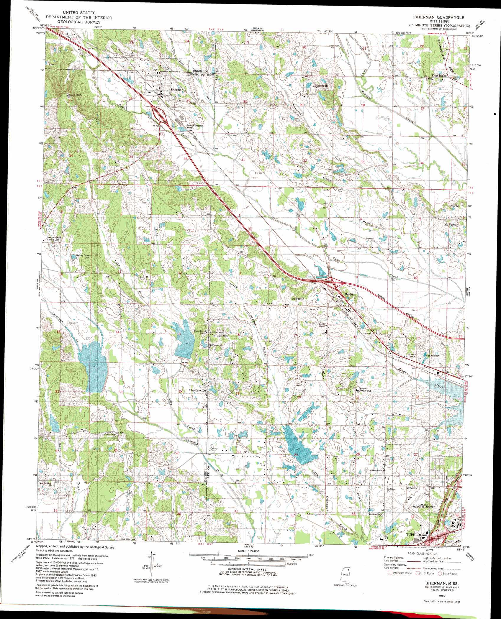
USGS Topo Quad 34088c7 - 1:24,000 scale
| Topo Map Name: | Sherman |
| USGS Topo Quad ID: | 34088c7 |
| Print Size: | ca. 21 1/4" wide x 27" high |
| Southeast Coordinates: | 34.25° N latitude / 88.75° W longitude |
| Map Center Coordinates: | 34.3125° N latitude / 88.8125° W longitude |
| U.S. State: | MS |
| Filename: | o34088c7.jpg |
| Download Map JPG Image: | Sherman topo map 1:24,000 scale |
| Map Type: | Topographic |
| Topo Series: | 7.5´ |
| Map Scale: | 1:24,000 |
| Source of Map Images: | United States Geological Survey (USGS) |
| Alternate Map Versions: |
Sherman MS 1980, updated 1981 Download PDF Buy paper map Sherman MS 2012 Download PDF Buy paper map Sherman MS 2015 Download PDF Buy paper map |
1:24,000 Topo Quads surrounding Sherman
Myrtle |
Keownville |
Pleasant Ridge |
Baldwyn |
Wheeler |
New Albany West |
New Albany East |
Ellistown |
Guntown |
Ratliff |
Northwest Pontotoc |
Northeast Pontotoc |
Sherman |
Tupelo |
Mooreville |
Southwest Pontotoc |
Southeast Pontotoc |
Bissell |
Verona |
Evergreen |
Houlka |
Troy |
Troy Se |
Shannon |
Nettleton |
> Back to 34088a1 at 1:100,000 scale
> Back to 34088a1 at 1:250,000 scale
> Back to U.S. Topo Maps home
Sherman topo map: Gazetteer
Sherman: Airports
C D Lemons Municipal Airport elevation 107m 351′Sherman: Dams
Chiwapa Structure 65 Dam elevation 114m 374′George Sims Lake Dam elevation 113m 370′
J W Vinson Lake Dam elevation 95m 311′
Town Creek Structure 23 Dam elevation 109m 357′
Town Creek Structure 24 Dam elevation 96m 314′
Towncreek Watershed 18 Dam elevation 90m 295′
Sherman: Populated Places
Belden elevation 106m 347′Chesterville elevation 117m 383′
Frog Island elevation 100m 328′
Macedonia elevation 116m 380′
Mount Vernon elevation 99m 324′
Sherman elevation 110m 360′
Traceland elevation 96m 314′
Tracewood elevation 96m 314′
Wildwood elevation 97m 318′
Sherman: Streams
Busfaloba Creek elevation 85m 278′Camp Creek elevation 88m 288′
Eads Creek elevation 106m 347′
Lilly Creek elevation 98m 321′
Russell Creek elevation 93m 305′
Ryan Creek elevation 108m 354′
Union Branch elevation 87m 285′
Wolf Creek elevation 99m 324′
Sherman digital topo map on disk
Buy this Sherman topo map showing relief, roads, GPS coordinates and other geographical features, as a high-resolution digital map file on DVD: