Talihina Topo Map Oklahoma
To zoom in, hover over the map of Talihina
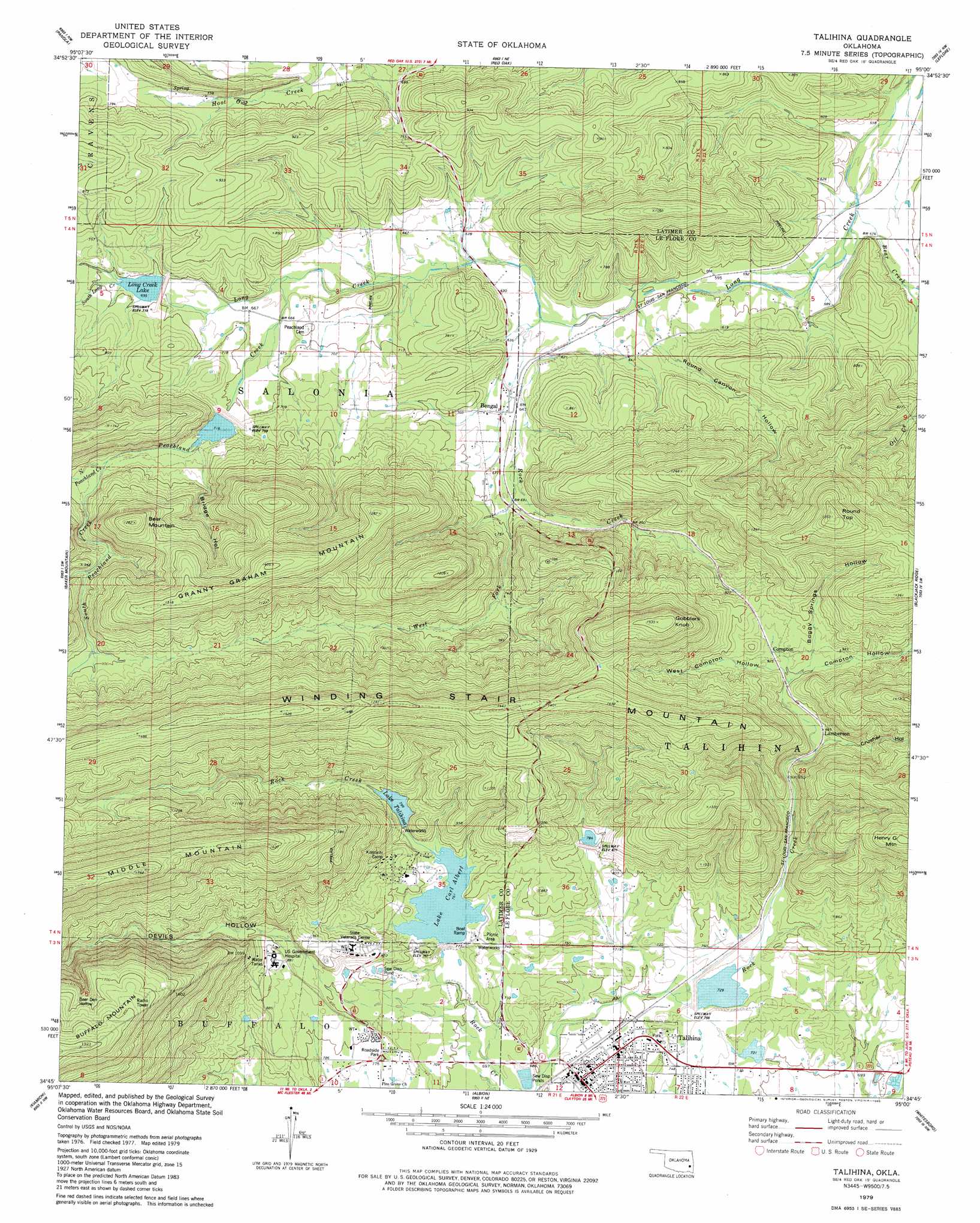
USGS Topo Quad 34095g1 - 1:24,000 scale
| Topo Map Name: | Talihina |
| USGS Topo Quad ID: | 34095g1 |
| Print Size: | ca. 21 1/4" wide x 27" high |
| Southeast Coordinates: | 34.75° N latitude / 95° W longitude |
| Map Center Coordinates: | 34.8125° N latitude / 95.0625° W longitude |
| U.S. State: | OK |
| Filename: | o34095g1.jpg |
| Download Map JPG Image: | Talihina topo map 1:24,000 scale |
| Map Type: | Topographic |
| Topo Series: | 7.5´ |
| Map Scale: | 1:24,000 |
| Source of Map Images: | United States Geological Survey (USGS) |
| Alternate Map Versions: |
Talihina OK 1979, updated 1980 Download PDF Buy paper map Talihina OK 2010 Download PDF Buy paper map Talihina OK 2013 Download PDF Buy paper map Talihina OK 2016 Download PDF Buy paper map |
1:24,000 Topo Quads surrounding Talihina
Quinton South |
Kinta |
Lequire |
Mccurtain Sw |
Potato Peaks |
Wilburton |
Panola |
Red Oak |
Leflore |
Summerfield |
Damon |
Baker Mountain |
Talihina |
Blackjack Ridge |
Leflore Se |
Yanush |
Kiamichi |
Albion |
Whitesboro |
Muse |
Clayton |
Albion Sw |
Albion Se |
Honobia |
Ludlow |
> Back to 34095e1 at 1:100,000 scale
> Back to 34094a1 at 1:250,000 scale
> Back to U.S. Topo Maps home
Talihina topo map: Gazetteer
Talihina: Airports
Choctaw Indian Hospital Heliport elevation 247m 810′Talihina: Dams
Dresser Lake Dam elevation 220m 721′Fourche Maline Creek Site 13 Dam elevation 209m 685′
Fourche Maline Creek Site 14 Dam elevation 218m 715′
Oknoname 077009 Dam elevation 243m 797′
Rock Creek Site 2 Dam elevation 218m 715′
Rock Creek Site 3 Dam elevation 249m 816′
Rock Creek Site 4 Dam elevation 222m 728′
Talihina Lake Dam elevation 241m 790′
Talihina: Populated Places
Bengal elevation 201m 659′Compton elevation 282m 925′
Lamberson elevation 267m 875′
Talihina elevation 208m 682′
Talihina: Reservoirs
Dresser Lake elevation 220m 721′Fourche Maline Creek Site 13 Reservoir elevation 209m 685′
Fourche Maline Creek Site 14 Reservoir elevation 218m 715′
Lake Carl Albert elevation 232m 761′
Lake Talihina elevation 243m 797′
Long Creek Lake elevation 221m 725′
Oknoname 077009 Reservoir elevation 243m 797′
Rock Creek Site 2 Reservoir elevation 218m 715′
Rock Creek Site 3 Reservoir elevation 249m 816′
Rock Creek Site 4 Reservoir elevation 222m 728′
Talihina Lake elevation 241m 790′
Talihina: Streams
Bear Creek elevation 171m 561′North Peachland Creek elevation 227m 744′
Peachland Creek elevation 197m 646′
Rock Creek elevation 183m 600′
Rock Creek elevation 184m 603′
Rock Creek elevation 232m 761′
South Long Creek elevation 212m 695′
South Peachland Creek elevation 227m 744′
West Fork Rock Creek elevation 201m 659′
Talihina: Summits
Bear Mountain elevation 392m 1286′Gobblers Knob elevation 466m 1528′
Granny Graham Mountain elevation 428m 1404′
Henry G Mountain elevation 429m 1407′
Round Top elevation 472m 1548′
Talihina: Valleys
Bear Den Hollow elevation 492m 1614′Boggy Springs Hollow elevation 285m 935′
Bridge Hollow elevation 230m 754′
Compton Hollow elevation 273m 895′
Crusher Hollow elevation 266m 872′
Devils Hollow elevation 261m 856′
Round Canyon Hollow elevation 183m 600′
West Compton Hollow elevation 272m 892′
Talihina digital topo map on disk
Buy this Talihina topo map showing relief, roads, GPS coordinates and other geographical features, as a high-resolution digital map file on DVD: