Wilson Topo Map North Carolina
To zoom in, hover over the map of Wilson
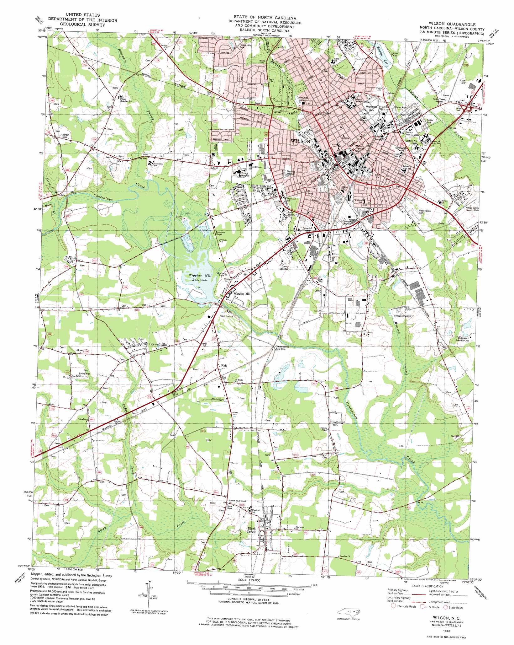
USGS Topo Quad 35077f8 - 1:24,000 scale
| Topo Map Name: | Wilson |
| USGS Topo Quad ID: | 35077f8 |
| Print Size: | ca. 21 1/4" wide x 27" high |
| Southeast Coordinates: | 35.625° N latitude / 77.875° W longitude |
| Map Center Coordinates: | 35.6875° N latitude / 77.9375° W longitude |
| U.S. State: | NC |
| Filename: | o35077f8.jpg |
| Download Map JPG Image: | Wilson topo map 1:24,000 scale |
| Map Type: | Topographic |
| Topo Series: | 7.5´ |
| Map Scale: | 1:24,000 |
| Source of Map Images: | United States Geological Survey (USGS) |
| Alternate Map Versions: |
Wilson NC 1978, updated 1979 Download PDF Buy paper map Wilson NC 1998, updated 2001 Download PDF Buy paper map Wilson NC 2010 Download PDF Buy paper map Wilson NC 2013 Download PDF Buy paper map Wilson NC 2016 Download PDF Buy paper map |
1:24,000 Topo Quads surrounding Wilson
Bunn East |
Spring Hope |
Nashville |
Rocky Mount |
Hartsease |
Middlesex |
Bailey |
Winstead Crossroads |
Elm City |
Pinetops |
Stancils Chapel |
Lucama |
Wilson |
Saratoga |
Fountain |
Kenly West |
Kenly East |
Fremont |
Stantonsburg |
Walstonburg |
Princeton |
Northwest Goldsboro |
Northeast Goldsboro |
Jason |
Snow Hill |
> Back to 35077e1 at 1:100,000 scale
> Back to 35076a1 at 1:250,000 scale
> Back to U.S. Topo Maps home
Wilson topo map: Gazetteer
Wilson: Dams
Wiggins Millpond Dam elevation 23m 75′Wilson: Parks
Fleming Stadium elevation 43m 141′Forest Hills Park elevation 42m 137′
Toisnot Park elevation 28m 91′
Wilson: Populated Places
Bel-Air Forest elevation 39m 127′Belle Meade elevation 43m 141′
Black Creek elevation 38m 124′
Boswellville elevation 40m 131′
Breckenridge elevation 44m 144′
British Woods elevation 44m 144′
Brookside Manor elevation 42m 137′
Cavalier Park elevation 44m 144′
Cavalier Terrace elevation 43m 141′
Contentnea Junction elevation 28m 91′
Crestview elevation 38m 124′
Dixie elevation 38m 124′
Edgewood elevation 39m 127′
Farmington Heights elevation 43m 141′
Farrior Park elevation 35m 114′
Five Points elevation 41m 134′
Forest Hills elevation 43m 141′
Forrest Road Homes elevation 41m 134′
Glenwood Hills elevation 34m 111′
Hominy Heights elevation 38m 124′
Imperial Estates elevation 39m 127′
Jennings Acres elevation 41m 134′
Lincoln Heights elevation 27m 88′
Millbrook elevation 40m 131′
Montclair elevation 33m 108′
Oakforest elevation 43m 141′
Pinewood Estates elevation 44m 144′
Quail Hollow elevation 42m 137′
Quail Ridge elevation 40m 131′
Sandy Creek elevation 35m 114′
Seven Hills elevation 33m 108′
Valleydale Estates elevation 39m 127′
Washington Place elevation 40m 131′
Waterford elevation 42m 137′
Westwood elevation 40m 131′
Whitfield Homes elevation 31m 101′
Wiggins Mill elevation 31m 101′
Wilco Manor Mobile Home Park elevation 37m 121′
Wildwood elevation 33m 108′
Wilson elevation 34m 111′
Woodfield elevation 39m 127′
Wilson: Post Offices
Wilson Post Office elevation 40m 131′Wilson: Reservoirs
Toisnot Reservoir elevation 27m 88′Wiggins Mill Reservoir elevation 23m 75′
Wilson: Streams
Bloomery Swamp elevation 28m 91′Cedar Creek elevation 26m 85′
Hominy Swamp elevation 20m 65′
Mill Branch elevation 29m 95′
Sandy Creek elevation 23m 75′
Shepard Branch elevation 29m 95′
Wilson digital topo map on disk
Buy this Wilson topo map showing relief, roads, GPS coordinates and other geographical features, as a high-resolution digital map file on DVD:
Atlantic Coast (NY, NJ, PA, DE, MD, VA, NC)
Buy digital topo maps: Atlantic Coast (NY, NJ, PA, DE, MD, VA, NC)
 map DVD")