Boiling Springs South Topo Map North Carolina
To zoom in, hover over the map of Boiling Springs South
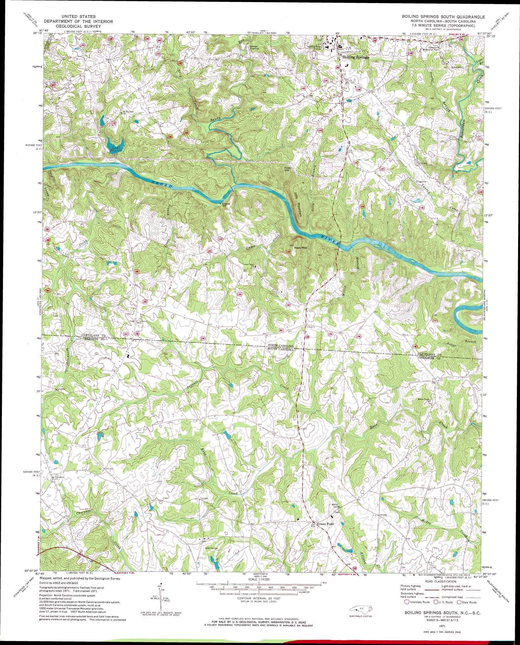
USGS Topo Quad 35081b6 - 1:24,000 scale
| Topo Map Name: | Boiling Springs South |
| USGS Topo Quad ID: | 35081b6 |
| Print Size: | ca. 21 1/4" wide x 27" high |
| Southeast Coordinates: | 35.125° N latitude / 81.625° W longitude |
| Map Center Coordinates: | 35.1875° N latitude / 81.6875° W longitude |
| U.S. States: | NC, SC |
| Filename: | o35081b6.jpg |
| Download Map JPG Image: | Boiling Springs South topo map 1:24,000 scale |
| Map Type: | Topographic |
| Topo Series: | 7.5´ |
| Map Scale: | 1:24,000 |
| Source of Map Images: | United States Geological Survey (USGS) |
| Alternate Map Versions: |
Boiling Springs South NC 1971, updated 1973 Download PDF Buy paper map Boiling Springs South NC 1971, updated 1984 Download PDF Buy paper map Boiling Springs South NC 1971, updated 1984 Download PDF Buy paper map Boiling Springs South NC 1976, updated 1978 Download PDF Buy paper map Boiling Springs South NC 2011 Download PDF Buy paper map Boiling Springs South NC 2013 Download PDF Buy paper map Boiling Springs South NC 2016 Download PDF Buy paper map |
1:24,000 Topo Quads surrounding Boiling Springs South
Rutherfordton North |
Sunshine |
Polkville |
Lawndale |
Cherryville |
Rutherfordton South |
Forest City |
Boiling Springs North |
Shelby |
Waco |
Fingerville East |
Chesnee |
Boiling Springs South |
Blacksburg North |
Grover |
Valley Falls |
Cowpens |
Gaffney |
Blacksburg South |
Kings Creek |
Spartanburg |
Pacolet |
Pacolet Mills |
Wilkinsville |
Hickory Grove |
> Back to 35081a1 at 1:100,000 scale
> Back to 35080a1 at 1:250,000 scale
> Back to U.S. Topo Maps home
Boiling Springs South topo map: Gazetteer
Boiling Springs South: Crossings
Jones Ferry (historical) elevation 197m 646′Boiling Springs South: Dams
Houser Dam elevation 224m 734′Mount Pleasant Fishing Lake Dam elevation 237m 777′
Boiling Springs South: Populated Places
Byersville (historical) elevation 231m 757′Goforth Cross Road (historical) elevation 236m 774′
Grassy Pond elevation 271m 889′
Maud elevation 290m 951′
Nicholsville (historical) elevation 211m 692′
Boiling Springs South: Reservoirs
Houser Lake elevation 224m 734′Lake Houser elevation 221m 725′
Mount Pleasant Fishing Lake elevation 237m 777′
Boiling Springs South: Streams
Ashworth Creek elevation 199m 652′Ashworth Creek elevation 199m 652′
Camp Creek elevation 196m 643′
Diller Branch elevation 185m 606′
Grog Creek elevation 203m 666′
Jolly Branch elevation 195m 639′
Jones Branch elevation 196m 643′
Poplar Branch elevation 202m 662′
Sandy Run elevation 197m 646′
Sarratt Creek elevation 231m 757′
Suck Creek elevation 200m 656′
Sugar Branch elevation 209m 685′
Willis Branch elevation 191m 626′
Boiling Springs South: Summits
Abes Mountain elevation 293m 961′Flint Hill elevation 272m 892′
Jolly Mountain elevation 271m 889′
Boiling Springs South digital topo map on disk
Buy this Boiling Springs South topo map showing relief, roads, GPS coordinates and other geographical features, as a high-resolution digital map file on DVD:
South Carolina, Western North Carolina & Northeastern Georgia
Buy digital topo maps: South Carolina, Western North Carolina & Northeastern Georgia