Montreat Topo Map North Carolina
To zoom in, hover over the map of Montreat
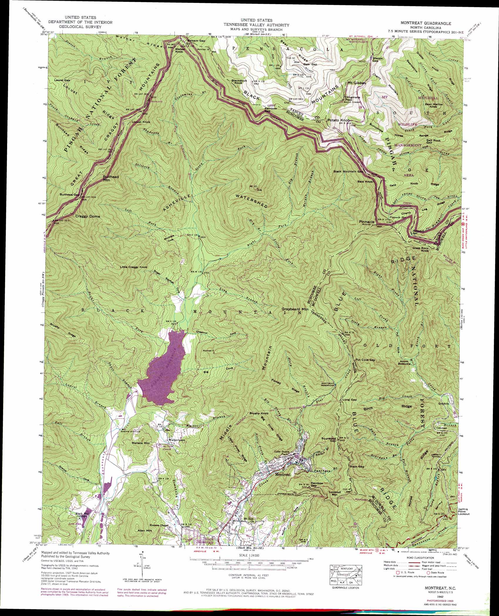
USGS Topo Quad 35082f3 - 1:24,000 scale
| Topo Map Name: | Montreat |
| USGS Topo Quad ID: | 35082f3 |
| Print Size: | ca. 21 1/4" wide x 27" high |
| Southeast Coordinates: | 35.625° N latitude / 82.25° W longitude |
| Map Center Coordinates: | 35.6875° N latitude / 82.3125° W longitude |
| U.S. State: | NC |
| Filename: | o35082f3.jpg |
| Download Map JPG Image: | Montreat topo map 1:24,000 scale |
| Map Type: | Topographic |
| Topo Series: | 7.5´ |
| Map Scale: | 1:24,000 |
| Source of Map Images: | United States Geological Survey (USGS) |
| Alternate Map Versions: |
Montreat NC 1935 Download PDF Buy paper map Montreat NC 1942, updated 1957 Download PDF Buy paper map Montreat NC 1942, updated 1964 Download PDF Buy paper map Montreat NC 1942, updated 1969 Download PDF Buy paper map Montreat NC 1942, updated 1973 Download PDF Buy paper map Montreat NC 1942, updated 1978 Download PDF Buy paper map Montreat NC 1943 Download PDF Buy paper map Montreat NC 1943 Download PDF Buy paper map Montreat NC 1994, updated 1998 Download PDF Buy paper map Montreat NC 2011 Download PDF Buy paper map Montreat NC 2013 Download PDF Buy paper map Montreat NC 2016 Download PDF Buy paper map |
| FStopo: | US Forest Service topo Montreat is available: Download FStopo PDF Download FStopo TIF |
1:24,000 Topo Quads surrounding Montreat
Sams Gap |
Bald Creek |
Burnsville |
Micaville |
Spruce Pine |
Mars Hill |
Barnardsville |
Mount Mitchell |
Celo |
Little Switzerland |
Weaverville |
Craggy Pinnacle |
Montreat |
Old Fort |
Marion West |
Asheville |
Oteen |
Black Mountain |
Moffitt Hill |
Sugar Hill |
Skyland |
Fruitland |
Bat Cave |
Lake Lure |
Shingle Hollow |
> Back to 35082e1 at 1:100,000 scale
> Back to 35082a1 at 1:250,000 scale
> Back to U.S. Topo Maps home
Montreat topo map: Gazetteer
Montreat: Areas
Asheville Watershed elevation 1106m 3628′Montreat: Basins
Acorn Bottoms elevation 727m 2385′Montreat: Dams
North Fork Dam elevation 793m 2601′Montreat: Gaps
Balsam Gap elevation 1625m 5331′Bear Gap elevation 1665m 5462′
Black Mountain Gap elevation 1572m 5157′
Buck Gap elevation 1107m 3631′
Bullhead Gap elevation 1708m 5603′
Laurel Gap elevation 1242m 4074′
Long Gap elevation 1130m 3707′
Pot Cove Gap elevation 1185m 3887′
Rainbow Gap elevation 1792m 5879′
Rainbow Gap elevation 997m 3270′
Salt Rock Gap elevation 1337m 4386′
Sourwood Gap elevation 1118m 3667′
Stepps Gap elevation 1853m 6079′
Montreat: Lakes
Lake Susan elevation 809m 2654′Montreat: Populated Places
Coleman elevation 669m 2194′Graphite elevation 610m 2001′
Montreat elevation 793m 2601′
Walkertown elevation 773m 2536′
Montreat: Ranges
Hallback Mountain elevation 1943m 6374′Montreat: Reservoirs
Burnett Reservoir elevation 789m 2588′Lake Eden elevation 709m 2326′
Montreat Reservoir elevation 1029m 3375′
North Fork Reservoir elevation 793m 2601′
Montreat: Ridges
Bald Knob Ridge elevation 1511m 4957′Bearwallow Ridge elevation 1523m 4996′
Big Piney Ridge elevation 1162m 3812′
Birch Ridge elevation 970m 3182′
Brushy Ridge elevation 1465m 4806′
Bullhead Ridge elevation 1361m 4465′
Buncombe Horse Range Ridge elevation 1433m 4701′
Cherry Log Ridge elevation 1456m 4776′
Forked Ridge elevation 1169m 3835′
Grassy Knob Ridge elevation 1509m 4950′
Horse Ridge elevation 905m 2969′
Little Piney Ridge elevation 1063m 3487′
Walker Ridge elevation 1481m 4858′
Montreat: Springs
Hemphill Spring elevation 1448m 4750′Pinnacle Spring elevation 1585m 5200′
Montreat: Streams
Acorn Branch elevation 690m 2263′Barn Branch elevation 687m 2253′
Big Branch elevation 994m 3261′
Big Creek elevation 629m 2063′
Big Piney Branch elevation 844m 2769′
Boardpan Branch elevation 703m 2306′
Dry Branch elevation 927m 3041′
Fall Branch elevation 727m 2385′
Fall Branch elevation 709m 2326′
Glassmine Branch elevation 1275m 4183′
Grassy Knob Branch elevation 1079m 3540′
Hemphill Creek elevation 1175m 3854′
Kitchen Branch elevation 812m 2664′
Laurel Branch elevation 735m 2411′
Left Fork Swannanor River elevation 877m 2877′
Left Prong Mill Creek elevation 812m 2664′
Left Prong South Toe River elevation 1175m 3854′
Little Fork elevation 921m 3021′
Little Piney Branch elevation 776m 2545′
Long Branch elevation 821m 2693′
Middle Fork Upper Creek elevation 1173m 3848′
Morgan Branch elevation 1053m 3454′
Puncheon Branch elevation 797m 2614′
Right Fork Swannanoa River elevation 829m 2719′
Right Prong Mill Creek elevation 927m 3041′
Saltrock Branch elevation 925m 3034′
Shadepen Branch elevation 1109m 3638′
Shute Branch elevation 753m 2470′
Slaty Branch elevation 860m 2821′
Slaty Branch elevation 915m 3001′
South Fork Upper Creek elevation 1079m 3540′
Stony Fork elevation 972m 3188′
Sugar Fork elevation 793m 2601′
Walker Branch elevation 745m 2444′
Montreat: Summits
Allen Mountain elevation 988m 3241′Bald Knob elevation 1627m 5337′
Bear Wallow Knob elevation 1460m 4790′
Blackstock Knob elevation 1911m 6269′
Brushy Knob elevation 1267m 4156′
Bullhead Mountain elevation 1798m 5898′
Cherry Mountain elevation 1702m 5583′
Chestnut Knob elevation 1361m 4465′
Clingmans Peak elevation 1990m 6528′
Craggy Dome elevation 1846m 6056′
Glass Rock Knob elevation 1469m 4819′
Graybeard Mountain elevation 1640m 5380′
Hallback elevation 1927m 6322′
Little Craggy Knob elevation 1495m 4904′
Locust Knob elevation 1673m 5488′
Lookout Mountain elevation 1142m 3746′
Middle Mountain elevation 1388m 4553′
Mount Gibbes elevation 1985m 6512′
Patton Knob elevation 1826m 5990′
Pinnacle elevation 1713m 5620′
Potato Knob elevation 1933m 6341′
Walker Knob elevation 1666m 5465′
Wallace Mountain elevation 931m 3054′
Montreat: Tunnels
Jarrett Tunnel elevation 704m 2309′Montreat: Valleys
Big Cove elevation 793m 2601′Buckeye Cove elevation 873m 2864′
Chestnut Cove elevation 794m 2604′
Granny Cove elevation 717m 2352′
Pot Cove elevation 708m 2322′
Sugar Springs Cove elevation 810m 2657′
Montreat digital topo map on disk
Buy this Montreat topo map showing relief, roads, GPS coordinates and other geographical features, as a high-resolution digital map file on DVD:
South Carolina, Western North Carolina & Northeastern Georgia
Buy digital topo maps: South Carolina, Western North Carolina & Northeastern Georgia