Floral Topo Map Arkansas
To zoom in, hover over the map of Floral
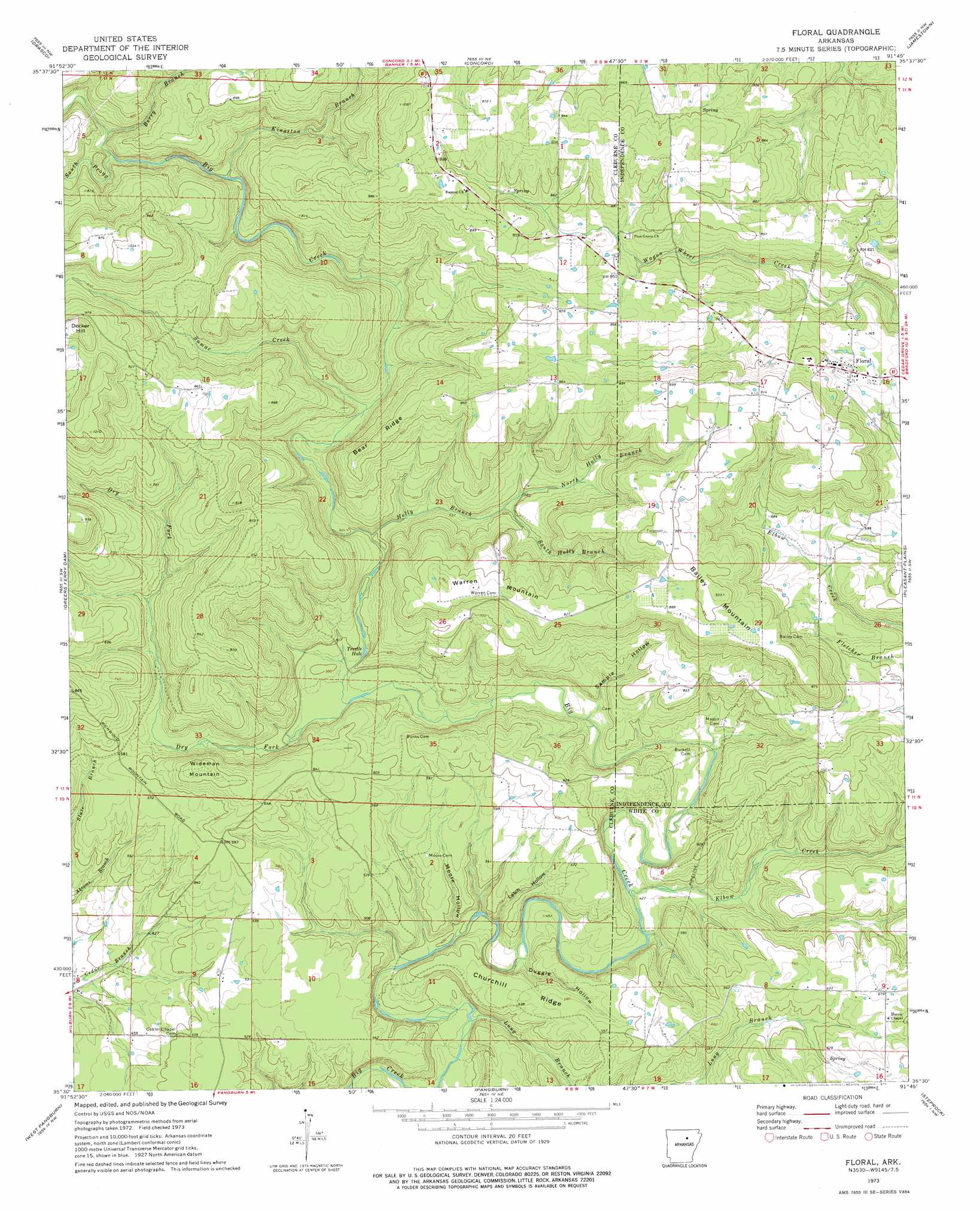
USGS Topo Quad 35091e7 - 1:24,000 scale
| Topo Map Name: | Floral |
| USGS Topo Quad ID: | 35091e7 |
| Print Size: | ca. 21 1/4" wide x 27" high |
| Southeast Coordinates: | 35.5° N latitude / 91.75° W longitude |
| Map Center Coordinates: | 35.5625° N latitude / 91.8125° W longitude |
| U.S. State: | AR |
| Filename: | o35091e7.jpg |
| Download Map JPG Image: | Floral topo map 1:24,000 scale |
| Map Type: | Topographic |
| Topo Series: | 7.5´ |
| Map Scale: | 1:24,000 |
| Source of Map Images: | United States Geological Survey (USGS) |
| Alternate Map Versions: |
Floral AR 1973, updated 1975 Download PDF Buy paper map Floral AR 1973, updated 1975 Download PDF Buy paper map Floral AR 2011 Download PDF Buy paper map Floral AR 2014 Download PDF Buy paper map |
1:24,000 Topo Quads surrounding Floral
Mountain View |
Marcella |
Bethesda |
Batesville |
Sulphur Rock |
Prim |
Drasco |
Concord |
Jamestown |
Salado |
Brownsville |
Greers Ferry Dam |
Floral |
Pleasant Plains |
Huff |
Heber Springs |
West Pangburn |
Pangburn |
Steprock |
Velvet Ridge |
Rose Bud |
Sidon |
Letona |
Judsonia |
Bald Knob |
> Back to 35091e1 at 1:100,000 scale
> Back to 35090a1 at 1:250,000 scale
> Back to U.S. Topo Maps home
Floral topo map: Gazetteer
Floral: Lakes
Trestle Hole elevation 145m 475′Floral: Populated Places
Floral elevation 235m 770′Tyler (historical) elevation 197m 646′
Floral: Post Offices
Floral Post Office elevation 234m 767′Floral: Ridges
Bear Ridge elevation 252m 826′Churchill Ridge elevation 161m 528′
Floral: Streams
Berry Branch elevation 217m 711′Dry Fork elevation 146m 479′
Elbow Creek elevation 128m 419′
Holly Branch elevation 155m 508′
Kingston Branch elevation 183m 600′
Long Branch elevation 143m 469′
North Holly Branch elevation 181m 593′
South Holly Branch elevation 179m 587′
South Prong Big Creek elevation 209m 685′
Sumac Creek elevation 164m 538′
Floral: Summits
Bailey Mountain elevation 280m 918′Decker Hill elevation 326m 1069′
Warren Mountain elevation 252m 826′
Wideman Mountain elevation 213m 698′
Floral: Valleys
Duggle Hollow elevation 134m 439′Latch Hollow elevation 123m 403′
Moore Hollow elevation 121m 396′
Sample Hollow elevation 147m 482′
Floral digital topo map on disk
Buy this Floral topo map showing relief, roads, GPS coordinates and other geographical features, as a high-resolution digital map file on DVD: