Drasco Topo Map Arkansas
To zoom in, hover over the map of Drasco
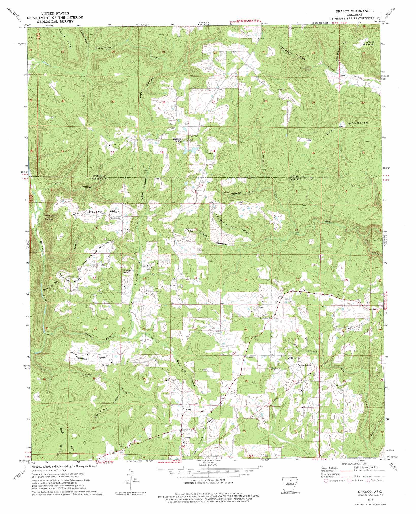
USGS Topo Quad 35091f8 - 1:24,000 scale
| Topo Map Name: | Drasco |
| USGS Topo Quad ID: | 35091f8 |
| Print Size: | ca. 21 1/4" wide x 27" high |
| Southeast Coordinates: | 35.625° N latitude / 91.875° W longitude |
| Map Center Coordinates: | 35.6875° N latitude / 91.9375° W longitude |
| U.S. State: | AR |
| Filename: | o35091f8.jpg |
| Download Map JPG Image: | Drasco topo map 1:24,000 scale |
| Map Type: | Topographic |
| Topo Series: | 7.5´ |
| Map Scale: | 1:24,000 |
| Source of Map Images: | United States Geological Survey (USGS) |
| Alternate Map Versions: |
Drasco AR 1973, updated 1975 Download PDF Buy paper map Drasco AR 1973, updated 1975 Download PDF Buy paper map Drasco AR 2011 Download PDF Buy paper map Drasco AR 2014 Download PDF Buy paper map |
1:24,000 Topo Quads surrounding Drasco
Fiftysix |
Sylamore |
Guion |
Mount Pleasant |
Sandtown |
Mountain View Sw |
Mountain View |
Marcella |
Bethesda |
Batesville |
Parma |
Prim |
Drasco |
Concord |
Jamestown |
Greers Ferry |
Brownsville |
Greers Ferry Dam |
Floral |
Pleasant Plains |
Quitman |
Heber Springs |
West Pangburn |
Pangburn |
Steprock |
> Back to 35091e1 at 1:100,000 scale
> Back to 35090a1 at 1:250,000 scale
> Back to U.S. Topo Maps home
Drasco topo map: Gazetteer
Drasco: Cliffs
Richey Bluff elevation 322m 1056′Victoria Bluffs elevation 370m 1213′
Drasco: Dams
Stair Lake Dam elevation 353m 1158′Drasco: Populated Places
Ben elevation 375m 1230′Bothersome (historical) elevation 376m 1233′
Drasco elevation 304m 997′
Fivemile elevation 274m 898′
Wolf Bayou elevation 317m 1040′
Drasco: Post Offices
Drasco Post Office elevation 307m 1007′Wolf Bayou Post Office elevation 317m 1040′
Drasco: Reservoirs
Stair Lake elevation 353m 1158′Drasco: Ridges
Hawkins Ridge elevation 351m 1151′McCarty Ridge elevation 335m 1099′
Nubbin Ridge elevation 270m 885′
Drasco: Streams
Brier Creek elevation 221m 725′Five Branch elevation 179m 587′
Fivemile Creek elevation 238m 780′
Kinsey Creek elevation 224m 734′
McIntosh Branch Big Creek elevation 223m 731′
Possum Walk Creek elevation 166m 544′
Drasco: Summits
Dug Hill elevation 405m 1328′Dump Mountain elevation 344m 1128′
Fortune Mountain elevation 331m 1085′
Sam Johnson Mountain elevation 364m 1194′
Schoolhouse Hill elevation 316m 1036′
Drasco: Valleys
Ben Frank Hollow elevation 238m 780′Blackground Hollow elevation 132m 433′
Blue Hole Hollow elevation 255m 836′
Deer Lick Hollow elevation 195m 639′
Douglas Hollow elevation 146m 479′
Dry Hollow elevation 196m 643′
Gypsum Hollow elevation 203m 666′
Ivy Hollow elevation 190m 623′
Lickin Hollow elevation 240m 787′
Logan Hollow elevation 282m 925′
Ogan Hollow elevation 289m 948′
Road Branch Hollow elevation 240m 787′
Shingle Knife Hollow elevation 240m 787′
Waterfall Hollow elevation 258m 846′
Drasco digital topo map on disk
Buy this Drasco topo map showing relief, roads, GPS coordinates and other geographical features, as a high-resolution digital map file on DVD: