Grange Topo Map Arkansas
To zoom in, hover over the map of Grange
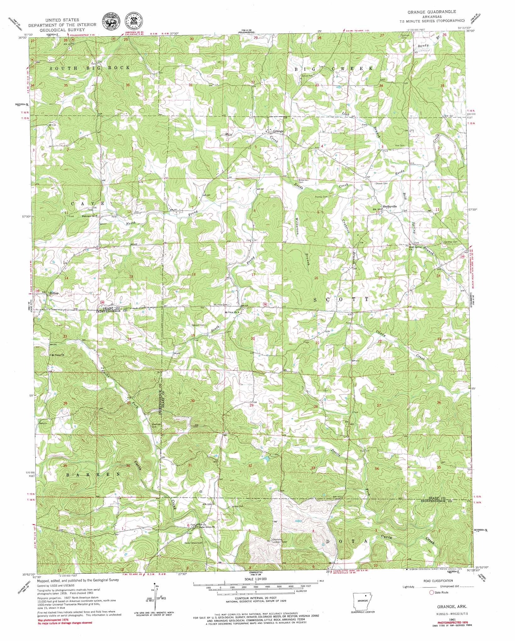
USGS Topo Quad 35091h4 - 1:24,000 scale
| Topo Map Name: | Grange |
| USGS Topo Quad ID: | 35091h4 |
| Print Size: | ca. 21 1/4" wide x 27" high |
| Southeast Coordinates: | 35.875° N latitude / 91.375° W longitude |
| Map Center Coordinates: | 35.9375° N latitude / 91.4375° W longitude |
| U.S. State: | AR |
| Filename: | o35091h4.jpg |
| Download Map JPG Image: | Grange topo map 1:24,000 scale |
| Map Type: | Topographic |
| Topo Series: | 7.5´ |
| Map Scale: | 1:24,000 |
| Source of Map Images: | United States Geological Survey (USGS) |
| Alternate Map Versions: |
Grange AR 1961, updated 1963 Download PDF Buy paper map Grange AR 1961, updated 1979 Download PDF Buy paper map Grange AR 2011 Download PDF Buy paper map Grange AR 2014 Download PDF Buy paper map |
1:24,000 Topo Quads surrounding Grange
Myron |
Ash Flat |
Sitka |
Ravenden |
Imboden |
Sidney |
Evening Shade |
Poughkeepsie |
Smithville |
Eaton |
Sandtown |
Cave City |
Grange |
Strawberry |
Strangers Home |
Batesville |
Sulphur Rock |
Charlotte |
Cord |
Swifton West |
Jamestown |
Salado |
Newark |
Jacksonport |
Tuckerman |
> Back to 35091e1 at 1:100,000 scale
> Back to 35090a1 at 1:250,000 scale
> Back to U.S. Topo Maps home
Grange topo map: Gazetteer
Grange: Dams
Ceder Lake Dam elevation 151m 495′Grange: Populated Places
Aetna elevation 128m 419′Mobley (historical) elevation 182m 597′
Shelbyville elevation 112m 367′
Simco (historical) elevation 109m 357′
Grange: Reservoirs
Cedar Lake elevation 151m 495′Grange: Streams
Bold Spring Branch elevation 95m 311′Cache Fork elevation 127m 416′
Crabtree Branch elevation 101m 331′
Devils Fork elevation 100m 328′
Lick Branch elevation 96m 314′
Mill Creek elevation 104m 341′
North Prong Reeds Creek elevation 110m 360′
Pools Chapel elevation 140m 459′
South Prong Reeds Creek elevation 110m 360′
Wilkerson Branch elevation 104m 341′
Grange digital topo map on disk
Buy this Grange topo map showing relief, roads, GPS coordinates and other geographical features, as a high-resolution digital map file on DVD: