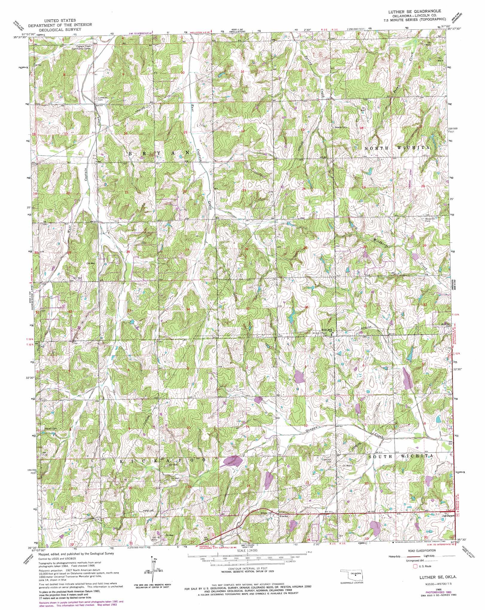
Luther Se Topo Map Oklahoma
To zoom in, hover over the map of Luther Se
USGS Topo Quad 35097e1 - 1:24,000 scale
| Topo Map Name: | Luther Se |
| USGS Topo Quad ID: | 35097e1 |
| Print Size: | ca. 21 1/4" wide x 27" high |
| Southeast Coordinates: | 35.5° N latitude / 97° W longitude |
| Map Center Coordinates: | 35.5625° N latitude / 97.0625° W longitude |
| U.S. State: | OK |
| Filename: | o35097e1.jpg |
| Download Map JPG Image: | Luther Se topo map 1:24,000 scale |
| Map Type: | Topographic |
| Topo Series: | 7.5´ |
| Map Scale: | 1:24,000 |
| Source of Map Images: | United States Geological Survey (USGS) |
| Alternate Map Versions: |
Luther SE OK 1966, updated 1967 Download PDF Buy paper map Luther SE OK 1966, updated 1983 Download PDF Buy paper map Luther SE OK 2009 Download PDF Buy paper map Luther SE OK 2012 Download PDF Buy paper map Luther SE OK 2016 Download PDF Buy paper map |
1:24,000 Topo Quads surrounding Luther Se
Guthrie Se |
Meridian |
Carney |
Tryon South |
Kendrick |
Arcadia |
Luther |
Wellston |
Chandler |
Davenport |
Jones |
Horseshoe Lake |
Luther Se |
Meeker |
Sparks |
Choctaw |
Harrah |
Mcloud |
Aydelotte |
Shawnee Ne |
Franklin |
Stella |
Shawnee Reservoir |
Shawnee |
Earlsboro |
> Back to 35097e1 at 1:100,000 scale
> Back to 35096a1 at 1:250,000 scale
> Back to U.S. Topo Maps home
Luther Se topo map: Gazetteer
Luther Se: Airports
Frost Ranch Airport elevation 316m 1036′Levescy Airport elevation 316m 1036′
Luther Se: Dams
Oknoname 08101 Dam elevation 285m 935′Quapaw Creek Site 22 Dam elevation 279m 915′
Quapaw Creek Site 24 Dam elevation 299m 980′
Quapaw Creek Site 25 Dam elevation 292m 958′
Quapaw Creek Site 26 Dam elevation 293m 961′
Quapaw Creek Site 27 Dam elevation 290m 951′
Quapaw Creek Site 28 Dam elevation 288m 944′
Quapaw Creek Site 29 Dam elevation 281m 921′
Quapaw Creek Site 30 Dam elevation 282m 925′
Quapaw Creek Site 32 Dam elevation 286m 938′
Luther Se: Populated Places
Fowler elevation 316m 1036′Jacktown elevation 304m 997′
Luther Se: Reservoirs
Oknoname 08101 Reservoir elevation 285m 935′Quapaw Creek Site 22 Reservoir elevation 279m 915′
Quapaw Creek Site 24 Reservoir elevation 299m 980′
Quapaw Creek Site 25 Reservoir elevation 292m 958′
Quapaw Creek Site 26 Reservoir elevation 293m 961′
Quapaw Creek Site 27 Reservoir elevation 290m 951′
Quapaw Creek Site 28 Reservoir elevation 288m 944′
Quapaw Creek Site 29 Reservoir elevation 281m 921′
Quapaw Creek Site 30 Reservoir elevation 282m 925′
Quapaw Creek Site 32 Reservoir elevation 286m 938′
Luther Se digital topo map on disk
Buy this Luther Se topo map showing relief, roads, GPS coordinates and other geographical features, as a high-resolution digital map file on DVD: