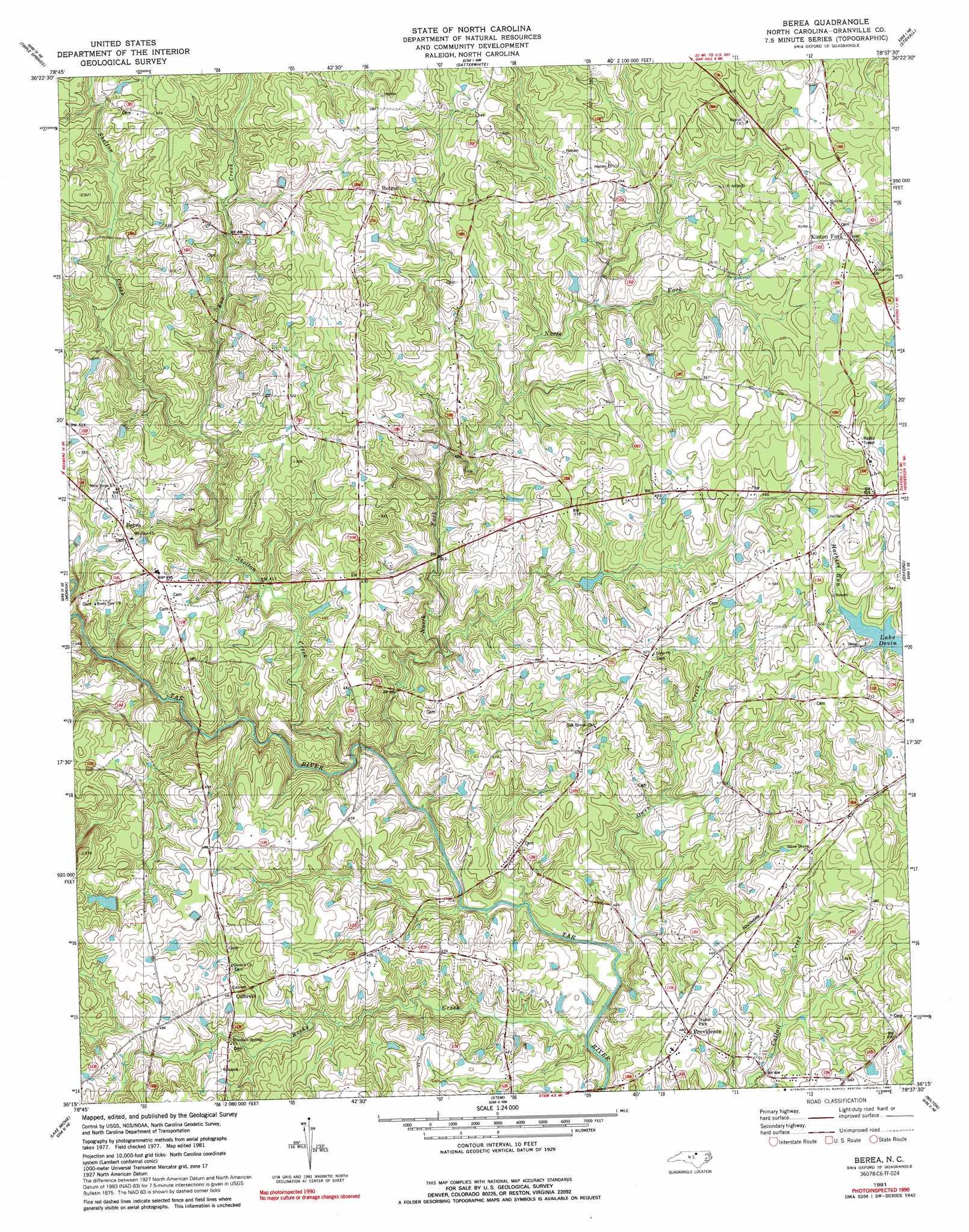
Berea Topo Map North Carolina
To zoom in, hover over the map of Berea
USGS Topo Quad 36078c6 - 1:24,000 scale
| Topo Map Name: | Berea |
| USGS Topo Quad ID: | 36078c6 |
| Print Size: | ca. 21 1/4" wide x 27" high |
| Southeast Coordinates: | 36.25° N latitude / 78.625° W longitude |
| Map Center Coordinates: | 36.3125° N latitude / 78.6875° W longitude |
| U.S. State: | NC |
| Filename: | o36078c6.jpg |
| Download Map JPG Image: | Berea topo map 1:24,000 scale |
| Map Type: | Topographic |
| Topo Series: | 7.5´ |
| Map Scale: | 1:24,000 |
| Source of Map Images: | United States Geological Survey (USGS) |
| Alternate Map Versions: |
Berea NC 1981, updated 1981 Download PDF Buy paper map Berea NC 1981, updated 1992 Download PDF Buy paper map Berea NC 2010 Download PDF Buy paper map Berea NC 2013 Download PDF Buy paper map Berea NC 2016 Download PDF Buy paper map |
1:24,000 Topo Quads surrounding Berea
Cluster Springs |
Virgilina |
Nelson |
Clarksville South |
Tungsten |
Roxboro |
Triple Springs |
Satterwhite |
Stovall |
Townsville |
Timberlake |
Moriah |
Berea |
Oxford |
Henderson |
Rougemont |
Lake Michie |
Stem |
Wilton |
Kittrell |
Northwest Durham |
Northeast Durham |
Creedmoor |
Grissom |
Franklinton |
> Back to 36078a1 at 1:100,000 scale
> Back to 36078a1 at 1:250,000 scale
> Back to U.S. Topo Maps home
Berea topo map: Gazetteer
Berea: Dams
Briggs Lake Dam elevation 142m 465′Veazsys Lake Dam elevation 149m 488′
Whites Lake Dam elevation 160m 524′
Berea: Populated Places
Berea elevation 155m 508′Culbreth elevation 149m 488′
Hebron elevation 177m 580′
Kinton Fork elevation 166m 544′
Providence elevation 134m 439′
Berea: Reservoirs
Briggs Lake elevation 142m 465′Veazsys Lake elevation 149m 488′
Whites Lake elevation 160m 524′
Berea: Streams
Fox Creek elevation 130m 426′Hachers Run elevation 148m 485′
North Fork Tar River elevation 117m 383′
Owen Creek elevation 115m 377′
Rocky Creek elevation 113m 370′
Shelton Creek elevation 118m 387′
Berea digital topo map on disk
Buy this Berea topo map showing relief, roads, GPS coordinates and other geographical features, as a high-resolution digital map file on DVD:
Western Virginia & Southern West Virginia
Buy digital topo maps: Western Virginia & Southern West Virginia