Creedmoor Topo Map North Carolina
To zoom in, hover over the map of Creedmoor
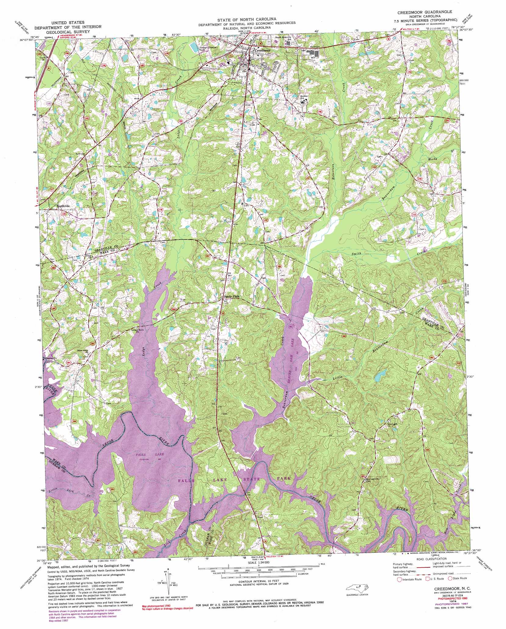
USGS Topo Quad 36078a6 - 1:24,000 scale
| Topo Map Name: | Creedmoor |
| USGS Topo Quad ID: | 36078a6 |
| Print Size: | ca. 21 1/4" wide x 27" high |
| Southeast Coordinates: | 36° N latitude / 78.625° W longitude |
| Map Center Coordinates: | 36.0625° N latitude / 78.6875° W longitude |
| U.S. State: | NC |
| Filename: | o36078a6.jpg |
| Download Map JPG Image: | Creedmoor topo map 1:24,000 scale |
| Map Type: | Topographic |
| Topo Series: | 7.5´ |
| Map Scale: | 1:24,000 |
| Source of Map Images: | United States Geological Survey (USGS) |
| Alternate Map Versions: |
Creedmoor NC 1974, updated 1977 Download PDF Buy paper map Creedmoor NC 1974, updated 1982 Download PDF Buy paper map Creedmoor NC 1974, updated 1986 Download PDF Buy paper map Creedmoor NC 1974, updated 1987 Download PDF Buy paper map Creedmoor NC 1974, updated 1992 Download PDF Buy paper map Creedmoor NC 1974, updated 1992 Download PDF Buy paper map Creedmoor NC 1998, updated 2000 Download PDF Buy paper map Creedmoor NC 2010 Download PDF Buy paper map Creedmoor NC 2013 Download PDF Buy paper map Creedmoor NC 2016 Download PDF Buy paper map |
1:24,000 Topo Quads surrounding Creedmoor
Timberlake |
Moriah |
Berea |
Oxford |
Henderson |
Rougemont |
Lake Michie |
Stem |
Wilton |
Kittrell |
Northwest Durham |
Northeast Durham |
Creedmoor |
Grissom |
Franklinton |
Southwest Durham |
Southeast Durham |
Bayleaf |
Wake Forest |
Rolesville |
Green Level |
Cary |
Raleigh West |
Raleigh East |
Knightdale |
> Back to 36078a1 at 1:100,000 scale
> Back to 36078a1 at 1:250,000 scale
> Back to U.S. Topo Maps home
Creedmoor topo map: Gazetteer
Creedmoor: Bridges
Boyces Bridge elevation 74m 242′Lawrences Bridge elevation 74m 242′
Newlight Bridge elevation 74m 242′
Creedmoor: Crossings
Interchange 189 elevation 113m 370′Creedmoor: Dams
Lake Hughes Dam elevation 97m 318′Creedmoor: Parks
Falls Lake State Recreation Area elevation 79m 259′Creedmoor: Populated Places
Creedmoor elevation 113m 370′North Side elevation 80m 262′
Sandy Plain elevation 108m 354′
Creedmoor: Reservoirs
Lake Hughes elevation 97m 318′Creedmoor: Streams
Beaverdam Creek elevation 75m 246′Ledge Creek elevation 74m 242′
Lick Creek elevation 74m 242′
Little Beaverdam Creek elevation 75m 246′
Little Ledge Creek elevation 75m 246′
Little Lick Creek elevation 74m 242′
New Light Creek elevation 74m 242′
Reedy Branch elevation 81m 265′
Robertson Creek elevation 79m 259′
Smith Creek elevation 75m 246′
Creedmoor digital topo map on disk
Buy this Creedmoor topo map showing relief, roads, GPS coordinates and other geographical features, as a high-resolution digital map file on DVD:
Western Virginia & Southern West Virginia
Buy digital topo maps: Western Virginia & Southern West Virginia