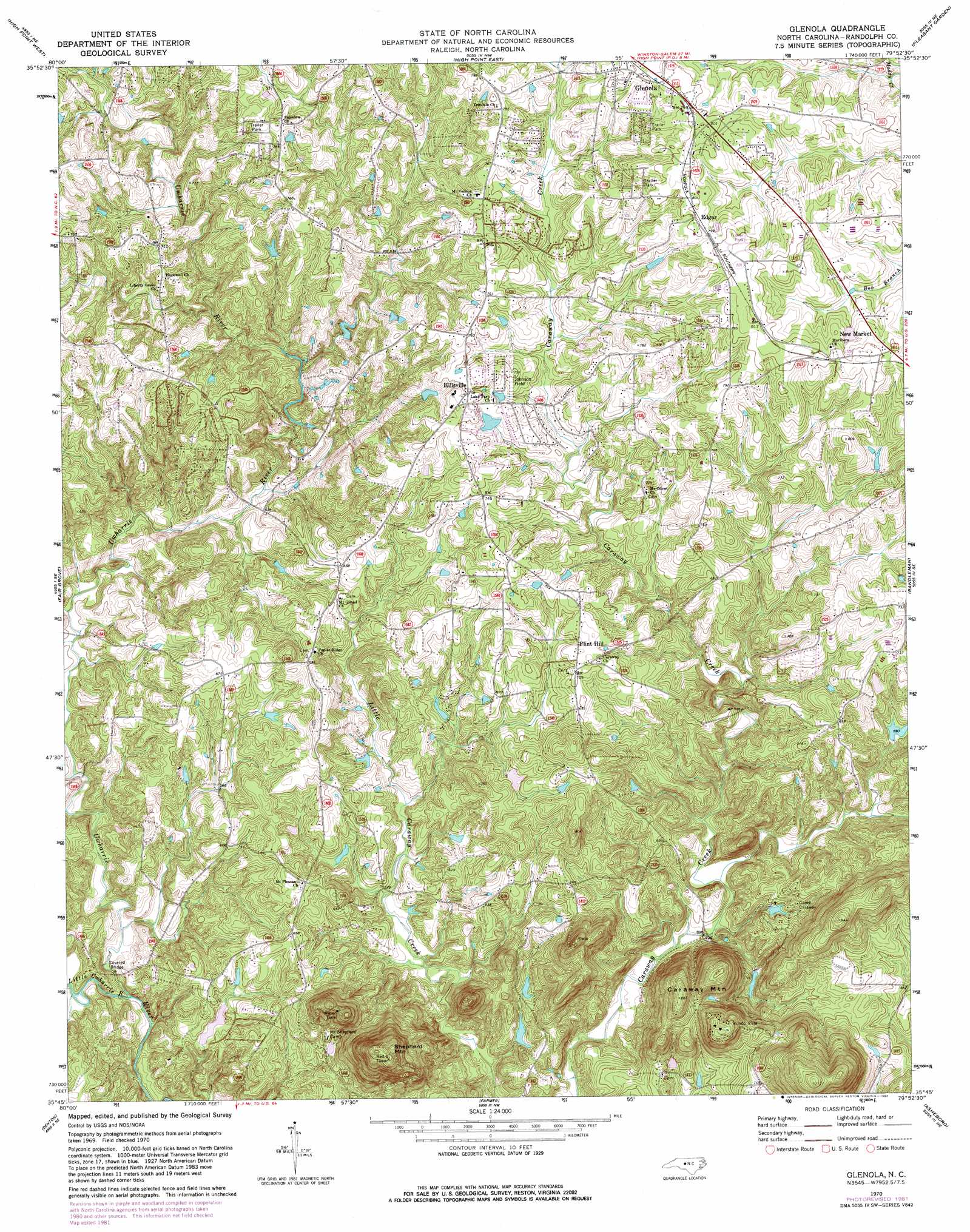
Glenola Topo Map North Carolina
To zoom in, hover over the map of Glenola
USGS Topo Quad 35079g8 - 1:24,000 scale
| Topo Map Name: | Glenola |
| USGS Topo Quad ID: | 35079g8 |
| Print Size: | ca. 21 1/4" wide x 27" high |
| Southeast Coordinates: | 35.75° N latitude / 79.875° W longitude |
| Map Center Coordinates: | 35.8125° N latitude / 79.9375° W longitude |
| U.S. State: | NC |
| Filename: | o35079g8.jpg |
| Download Map JPG Image: | Glenola topo map 1:24,000 scale |
| Map Type: | Topographic |
| Topo Series: | 7.5´ |
| Map Scale: | 1:24,000 |
| Source of Map Images: | United States Geological Survey (USGS) |
| Alternate Map Versions: |
Glenola NC 1970, updated 1973 Download PDF Buy paper map Glenola NC 1970, updated 1982 Download PDF Buy paper map Glenola NC 2010 Download PDF Buy paper map Glenola NC 2013 Download PDF Buy paper map Glenola NC 2016 Download PDF Buy paper map |
1:24,000 Topo Quads surrounding Glenola
Winston-Salem East |
Kernersville |
Guilford |
Greensboro |
Mcleansville |
Midway |
High Point West |
High Point East |
Pleasant Garden |
Climax |
Lexington East |
Fair Grove |
Glenola |
Randleman |
Grays Chapel |
Denton Nw |
Denton |
Farmer |
Asheboro |
Ramseur |
High Rock |
Handy |
Eleazer |
Seagrove |
Erect |
> Back to 35079e1 at 1:100,000 scale
> Back to 35078a1 at 1:250,000 scale
> Back to U.S. Topo Maps home
Glenola topo map: Gazetteer
Glenola: Airports
Johnson Field elevation 219m 718′Glenola: Dams
Beard Lake Dam elevation 216m 708′Camp Keyauwee Lake Dam elevation 189m 620′
Caraway Dam Number One elevation 188m 616′
Caraway Dam Number Two elevation 169m 554′
J B White Lake Dam elevation 161m 528′
Kivett Lake Dam Number One elevation 201m 659′
Leath Dam elevation 166m 544′
Thompson-Arthur Lake Dam elevation 176m 577′
Wesleyan Youth Camp Lake Dam elevation 206m 675′
Glenola: Populated Places
Edgar elevation 244m 800′Flint Hill elevation 214m 702′
Glenola elevation 241m 790′
Mundo Vista elevation 281m 921′
Glenola: Reservoirs
Beard Lake elevation 216m 708′Camp Keyauwee Lake elevation 189m 620′
Caraway Lake Number One elevation 188m 616′
Caraway Lake Number Two elevation 169m 554′
J B White Lake elevation 161m 528′
Kivett Lake Number One elevation 201m 659′
Leath Lake elevation 166m 544′
Thompson-Arthur Lake elevation 176m 577′
Wesleyan Youth Camp Lake elevation 206m 675′
Glenola: Streams
Little Uwharrie River elevation 144m 472′Glenola: Summits
Caraway Mountain elevation 344m 1128′Shepherd Mountain elevation 351m 1151′
Glenola digital topo map on disk
Buy this Glenola topo map showing relief, roads, GPS coordinates and other geographical features, as a high-resolution digital map file on DVD:
South Carolina, Western North Carolina & Northeastern Georgia
Buy digital topo maps: South Carolina, Western North Carolina & Northeastern Georgia