Powell Plateau Topo Map Arizona
To zoom in, hover over the map of Powell Plateau
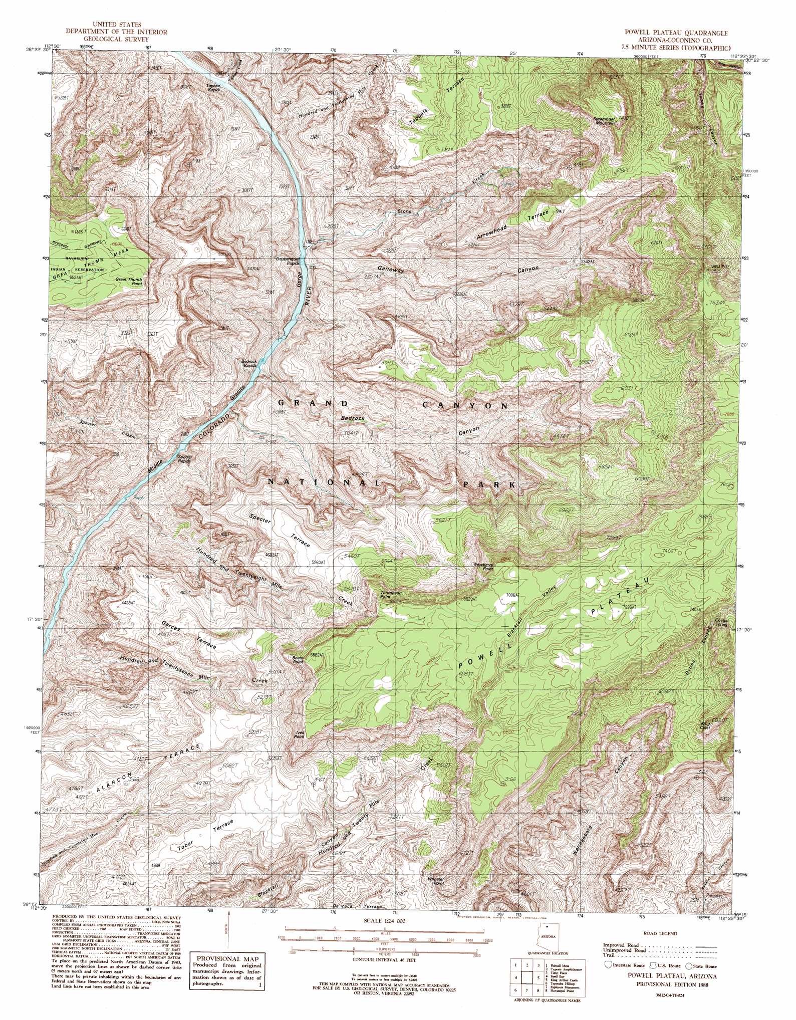
USGS Topo Quad 36112c4 - 1:24,000 scale
| Topo Map Name: | Powell Plateau |
| USGS Topo Quad ID: | 36112c4 |
| Print Size: | ca. 21 1/4" wide x 27" high |
| Southeast Coordinates: | 36.25° N latitude / 112.375° W longitude |
| Map Center Coordinates: | 36.3125° N latitude / 112.4375° W longitude |
| U.S. State: | AZ |
| Filename: | o36112c4.jpg |
| Download Map JPG Image: | Powell Plateau topo map 1:24,000 scale |
| Map Type: | Topographic |
| Topo Series: | 7.5´ |
| Map Scale: | 1:24,000 |
| Source of Map Images: | United States Geological Survey (USGS) |
| Alternate Map Versions: |
Powell Plateau AZ 1988, updated 1988 Download PDF Buy paper map Powell Plateau AZ 1988, updated 1988 Download PDF Buy paper map Powell Plateau AZ 2011 Download PDF Buy paper map Powell Plateau AZ 2014 Download PDF Buy paper map |
1:24,000 Topo Quads surrounding Powell Plateau
Grama Spring |
Jumpup Point |
Sowats Spring |
Big Springs |
Telephone Hill |
Kanab Point |
Fishtail Mesa |
Tapeats Amphitheater |
Timp Point |
De Motte Park |
Havasu Falls |
Fossil Bay |
Powell Plateau |
King Arthur Castle |
Kanabownits Spring |
Supai |
Topocoba Hilltop |
Explorers Monument |
Havasupai Point |
Shiva Temple |
Driftwood Canyon |
Antelope Point |
Chamisa Tank |
Piute Point |
Grand Canyon |
> Back to 36112a1 at 1:100,000 scale
> Back to 36112a1 at 1:250,000 scale
> Back to U.S. Topo Maps home
Powell Plateau topo map: Gazetteer
Powell Plateau: Benches
Alarcon Terrace elevation 1392m 4566′Arrowhead Terrace elevation 1781m 5843′
Feroz Terrace elevation 1657m 5436′
Garces Terrace elevation 1536m 5039′
Specter Terrace elevation 1588m 5209′
Tobar Terrace elevation 1529m 5016′
Powell Plateau: Capes
Great Thumb Point elevation 1928m 6325′Powell Plateau: Cliffs
Beale Point elevation 1838m 6030′Ives Point elevation 1929m 6328′
Newberry Point elevation 2053m 6735′
Thompson Point elevation 1851m 6072′
Wheeler Point elevation 1985m 6512′
Powell Plateau: Plains
Powell Plateau elevation 2190m 7185′Powell Plateau: Rapids
Bedrock Rapids elevation 621m 2037′Deubendorff Rapids elevation 606m 1988′
Specter Rapids elevation 682m 2237′
Tapeats Rapids elevation 607m 1991′
Powell Plateau: Springs
Cougar Spring elevation 2043m 6702′Powell Plateau: Streams
Hundred and Thirtythree Mile Creek elevation 608m 1994′Hundred and Twentyeight Mile Creek elevation 621m 2037′
Hundred and Twentyseven Mile Creek elevation 623m 2043′
Stone Creek elevation 611m 2004′
Tapeats Creek elevation 605m 1984′
Powell Plateau: Summits
King Crest elevation 2029m 6656′Steamboat Mountain elevation 2123m 6965′
Powell Plateau: Valleys
Bedrock Canyon elevation 684m 2244′Blacktail Valley elevation 1933m 6341′
Dutton Canyon elevation 1803m 5915′
Galloway Canyon elevation 659m 2162′
Granite Gorge elevation 735m 2411′
Middle Granite Gorge elevation 605m 1984′
Specter Chasm elevation 695m 2280′
Powell Plateau digital topo map on disk
Buy this Powell Plateau topo map showing relief, roads, GPS coordinates and other geographical features, as a high-resolution digital map file on DVD: