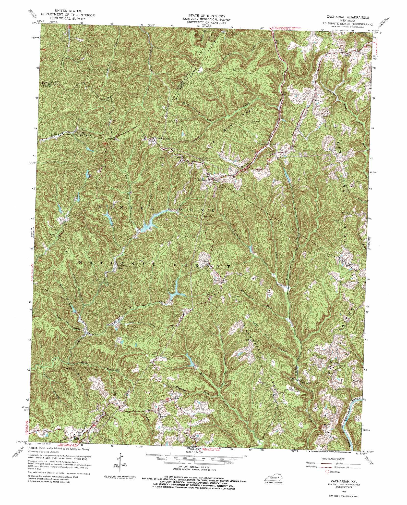
Zachariah Topo Map Kentucky
To zoom in, hover over the map of Zachariah
USGS Topo Quad 37083f6 - 1:24,000 scale
| Topo Map Name: | Zachariah |
| USGS Topo Quad ID: | 37083f6 |
| Print Size: | ca. 21 1/4" wide x 27" high |
| Southeast Coordinates: | 37.625° N latitude / 83.625° W longitude |
| Map Center Coordinates: | 37.6875° N latitude / 83.6875° W longitude |
| U.S. State: | KY |
| Filename: | o37083f6.jpg |
| Download Map JPG Image: | Zachariah topo map 1:24,000 scale |
| Map Type: | Topographic |
| Topo Series: | 7.5´ |
| Map Scale: | 1:24,000 |
| Source of Map Images: | United States Geological Survey (USGS) |
| Alternate Map Versions: |
Zachariah KY 1953, updated 1956 Download PDF Buy paper map Zachariah KY 1953, updated 1963 Download PDF Buy paper map Zachariah KY 1966, updated 1968 Download PDF Buy paper map Zachariah KY 1966, updated 1988 Download PDF Buy paper map Zachariah KY 2011 Download PDF Buy paper map Zachariah KY 2013 Download PDF Buy paper map Zachariah KY 2016 Download PDF Buy paper map |
| FStopo: | US Forest Service topo Zachariah is available: Download FStopo PDF Download FStopo TIF |
1:24,000 Topo Quads surrounding Zachariah
Levee |
Means |
Frenchburg |
Scranton |
Ezel |
Clay City |
Stanton |
Slade |
Pomeroyton |
Hazel Green |
Irvine |
Cobhill |
Zachariah |
Campton |
Landsaw |
Leighton |
Heidelberg |
Beattyville |
Tallega |
Jackson |
Mckee |
Sturgeon |
Booneville |
Cowcreek |
Canoe |
> Back to 37083e1 at 1:100,000 scale
> Back to 37082a1 at 1:250,000 scale
> Back to U.S. Topo Maps home
Zachariah topo map: Gazetteer
Zachariah: Populated Places
Barker Branch elevation 309m 1013′Booth elevation 340m 1115′
El Park elevation 308m 1010′
Fincastle elevation 218m 715′
Fixer elevation 268m 879′
Harris elevation 271m 889′
Leeco elevation 383m 1256′
Rogers elevation 373m 1223′
Standing Rock elevation 379m 1243′
Torrent elevation 289m 948′
Zachariah elevation 378m 1240′
Zoe elevation 349m 1145′
Zachariah: Post Offices
Booth Post Office (historical) elevation 339m 1112′Rogers Post Office elevation 374m 1227′
Torrent Post Office (historical) elevation 286m 938′
Zachariah Post Office (historical) elevation 378m 1240′
Zachariah: Ridges
Big Andy Ridge elevation 316m 1036′Big Bend Ridge elevation 396m 1299′
Little Bend Ridge elevation 373m 1223′
Shumaker Ridge elevation 333m 1092′
Zachariah: Streams
Bald Rock Fork elevation 234m 767′Beech Stand Fork elevation 302m 990′
Boonesboro Fork elevation 222m 728′
Bowman Fork elevation 232m 761′
Buckner Branch elevation 246m 807′
Caves Fork elevation 244m 800′
Chester Creek elevation 268m 879′
Cowan Fork elevation 234m 767′
Crow Drive Creek elevation 266m 872′
Hauk Branch elevation 235m 770′
Hell for Certain Creek elevation 229m 751′
Huff Cave Branch elevation 217m 711′
Miller Fork elevation 239m 784′
Peddler Creek elevation 220m 721′
Sinking Fork elevation 255m 836′
Torrent Creek elevation 286m 938′
Townsend Fork elevation 284m 931′
Zachariah Fork elevation 268m 879′
Zachariah: Valleys
Coalbank Hollow elevation 255m 836′Cold Oak Hollow elevation 250m 820′
Flat Hollow elevation 262m 859′
Hog Gap Hollow elevation 261m 856′
Spring Hollow elevation 238m 780′
Zachariah digital topo map on disk
Buy this Zachariah topo map showing relief, roads, GPS coordinates and other geographical features, as a high-resolution digital map file on DVD:
Western Virginia & Southern West Virginia
Buy digital topo maps: Western Virginia & Southern West Virginia